Our new ticketing site is now live! Using either this or the original site (both powered by TrainSplit) helps support the running of the forum with every ticket purchase! Find out more and ask any questions/give us feedback in this thread!
I think what was meant was in the 2/3 months or so the bridge was closed would services terminate at Cambridge in the north and Cambridge South from the south. My guess would be yes.
A closure of the road while they rebuild an overbridge doesn’t necessarily mean the railway will be closed for a similarly long period. Once the existing spans are lifted out they’ll usually be able to reopen the line, and build new abutments from the outside, away from the line.
A closure of the road while they rebuild an overbridge doesn’t necessarily mean the railway will be closed for a similarly long period. Once the existing spans are lifted out they’ll usually be able to reopen the line, and build new abutments from the outside, away from the line.
That said, some of the EWR changes suggested are about supporting more trains turning at Cambridge North from the North during works at Cambridge Station, I believe, so I wouldn't be too surprised if there's some turning at South too (though not sure if there's as much road etc. capacity). Probably drifting off topic, anyway.
A closure of the road while they rebuild an overbridge doesn’t necessarily mean the railway will be closed for a similarly long period. Once the existing spans are lifted out they’ll usually be able to reopen the line, and build new abutments from the outside, away from the line.
As a child I was impressed by the way half of the brick bridge carrying the Portsmouth main line over New Malden High St was demolished and a new girder bridge put in its place over a weekend, the process being repeated for the other half a month later. Why are we incapable of doing these feats of engineering any more?
Thanks, I'd forgotten this. Cambridge traffic in 2006 was very different from 2026, but, on the other hand, alternative places to cross the railway were more limited.
I first visited Cambridge in 1992 and moved to the area in 1999.
Huge amount of changes over that time - mostly positive - from a fairly sleepy academic town to one of the top tech clusters in Europe.
Nothing has really been done about traffic though. The congestion charging zone was flawed (it covered a far too big area) and rightly scrapped. I'd rather see moves to a car free city centre.
As a child I was impressed by the way half of the brick bridge carrying the Portsmouth main line over New Malden High St was demolished and a new girder bridge put in its place over a weekend, the process being repeated for the other half a month later. Why are we incapable of doing these feats of engineering any more?
1. Rail over road is always quicker and easier, you aren't comparing like for like.
2. For road over rail (as in the Cambridge situation) the utilities situation has got worse with more providers and lots more old abandoned utilities.
3. Quick replacement at New Malden was aided by the structure below being well built.
I first visited Cambridge in 1992 and moved to the area in 1999.
Huge amount of changes over that time - mostly positive - from a fairly sleepy academic town to one of the top tech clusters in Europe.
Nothing has really been done about traffic though. The congestion charging zone was flawed (it covered a far too big area) and rightly scrapped. I'd rather see moves to a car free city centre.
Apart from Cambridge gained City status back in 1951 !!!
I moved to Cambridge in 1969 and I can tell you that back then it was a very sleepy city. By 1992 the kite area had been redeveloped and had gained the Grafton Centre and Cambridge had moved on massively (the cattle market had been turned into the Junction and an industrial estate with the Royal Mail Sorting office moving there from Mill Road). Since then Cambridge has moved on massively further, yet the same 'Ring Road' exists to this day, I'm guessing the college's had to much of a say in the road planning of the city as it grew. Hence why Cambridge North and now South have been built as the city is now a nightmare for the motorist as since 1992 the city council has actively discouraged motorists driving in Cambridge due to their crass planning. Yet other major cities have dual carriageway ring roads and less traffic congestion because of it.
And this problem with utilities is very obvious in many of the Transpennine Upgrade ‘road over rail’ bridges, but time spent solving that problem still shouldn’t result in many months of rail closures, even if (as is usual), it closes the road.
I‘ve wondered if for new bridges they should just hang utility services outside the parapets, or maybe on a utilities bridge - but I suppose it would then be at risk from climbing and trespass. However you’d hope that new installations were better installed and better documented for future maintenance of the deck.
When it was being built the rumours were that it had seven floors below ground level, constructed to serve the regional govt headquarters in the former govt buildings complex in Brooklands Avenue (now redeveloped as upmarket flats). Apparently water ingress was a major problem as Hobson's Brook runs right next to the site.
I‘ve wondered if for new bridges they should just hang utility services outside the parapets, or maybe on a utilities bridge - but I suppose it would then be at risk from climbing and trespass. However you’d hope that new installations were better installed and better documented for future maintenance of the deck.
I was thinking the same. Having relocated the utlities to a separate structure would make craning the new road bridge into place a lot simpler. Or they could maybe divert the road onto a temporary Bailey bridge alongside. There was a recent lane closure in Long Road (en route to my dentist!) from which we learnt that having only one lane is manageable, even in the rush hour.
I moved to Cambridge in 1969 and I can tell you that back then it was a very sleepy city. By 1992 the kite area had been redeveloped and had gained the Grafton Centre and Cambridge had moved on massively (the cattle market had been turned into the Junction and an industrial estate with the Royal Mail Sorting office moving there from Mill Road). Since then Cambridge has moved on massively further, yet the same 'Ring Road' exists to this day, I'm guessing the college's had to much of a say in the road planning of the city as it grew. Hence why Cambridge North and now South have been built as the city is now a nightmare for the motorist as since 1992 the city council has actively discouraged motorists driving in Cambridge due to their crass planning. Yet other major cities have dual carriageway ring roads and less traffic congestion because of it.
I grew up in Cambridge in the 1960s and 1970s. I still have an early 1970s street map, just after the Elizabeth Bridge opened in 1971. This, and short sections of nearby Newmarket Road and East Road, are the only dual carriageways in Cambridge apart from a short section of Madingley Road. Prior to the opening of the northern bypass (now the A14) this was the main east west route for through traffic.
Various proposals to develop the Kite area of the city culminated in the Grafton Centre which opened in 1984, taking advantage of the road access via Elizabeth Way and Newmarket Road. The Grafton Centre, and the retail parks off Newmarket Road, were designed for shopping by car.
There were various controversial proposals for the Cambridge road network in the 1970s. One was to extend dual carriageway the full length of East Road and along Gonville Place, taking a strip off Parker's Piece. This was around the time when the Queen Anne Terrace Car Park was built.
The early 1970s street map shows various sections of a ring road that were never built. This included:
Huntingdon Road to Barton Road a bit west of Storeys Way and Wilberforce Road
Barton Road to Brooklands Avenue across Lammas Land and Sheeps Green
Wadloes Road to Cam Causeway across Ditton Meadows
This would have required two new bridges over the river, both in environmentally sensitive locations.
The only bits that got built were extensions of Barnwell Road to Brooks Road and Kings Hedges Road to Histon Road.
Although it isn't on the map I think there would also have been a section from Histon Road to Huntingdon Road through the NIAB land.
The ring road was regarded as much lower priority once the northern and western bypasses were approved, now the A14 and M11, taking through traffic out of Cambridge.
== Doublepost prevention - post automatically merged: ==
There was another weird relief road shown dotted in a map I have of a similar date. From memory it would have gone across Jesus Green and up through the Carlyle Road area to Murkett's Corner (jn with Huntingdon Road). Not sure of the details atm but I will look it up when I am next near my copy.
Can't have been a realistic proposition given the amount of housing that would have needed to be demolished.
In general the ring road system works surprisingly well. Biggest delay IME is caused by traffic merging at Newnham roundabout and queueing all along Fen Causeway. Various changes to the junction with Trumpington St have not made a lot of difference - I first remember it as two unsynchronised sets of traffic lights.
These roads look quite excessively wide for the minor residential streets they are today. I guess because they were built with the intention of being linked up in a major ring road.
These roads look quite excessively wide for the minor residential streets they are today. I guess because they were built with the intention of being linked up in a major ring road.
To confirm, the signalling has been designed to allow terminating trains from the South. It's limited, in that trains from Royston must use platforms 3 and 4 as there is no crosover to allow them to get into platforms 1 or 2 northbound.
similarly, trains from Shelford must use platforms 1 or 2, as there is no crossover to allow trains from 3 and 4 to cross back to this direction after terminating.
Isolations would also be feasible - there are switches to the North of the platforms and south of the bridge.
Rail replacement bus services is where this gets more tricky. As there is no station car park, there is only either the pick up / drop off road or Francis Crick Avenue, bus management would be challenging, and possibly unfeasible. If this was the case, most passengers would still be transferred to replacement busses from Audley End or Whittlesford Parkway.
There were discussions about how to manage rail replacement bussess and what the best solution would be happening when I left the project, but I have no idea what the end resolution was.
Rail replacement bus services is where this gets more tricky. As there is no station car park, there is only either the pick up / drop off road or Francis Crick Avenue, bus management would be challenging, and possibly unfeasible. If this was the case, most passengers would still be transferred to replacement busses from Audley End or Whittlesford Parkway.
There were discussions about how to manage rail replacement bussess and what the best solution would be happening when I left the project, but I have no idea what the end resolution was.
For the case of planned work, I would have thought an intensive RRB service could make use of the busway to ferry passengers to the main station and Trumpington park and ride for onward travel. I would guesstimate the road between AZ and The Papworth would provide space to queue and board busses but it can only be used with the busway.
A fair question. My hope was that between whippet and stage coach there would be sufficient spare vehicles available to run an intensive service. If spare drivers were available I expect you would need (or at least not be able to utilise) no more than 10-15 which must be considerably less than the total used on the full length busway route.
A fair question. My hope was that between whippet and stage coach there would be sufficient spare vehicles available to run an intensive service. If spare drivers were available I expect you would need (or at least not be able to utilise) no more than 10-15 which must be considerably less than the total used on the full length busway route.
The important thing to remember with the southern end of the busway is that it is single deckers only.
Stagecoach do not have any spare busway compatible single deckers. It doesn't help that in recent years they have lost 2 vehicles, one to fire and one to collision. As a result there are a few of the original 2009 single deckers hanging on in service, and they are not going to last forever.
Whippet still has most of the vehicles that were used on the Universal service before it went electric, but they are already down from 11 to 9 and they are used on Whippet's other routes.
And vehicles are only part of the problem, who is going to do the driving?
If the closure can be kept to the school summer holiday then the available buses and drivers will be those normally deployed on schools contracts, and they won't go on the busway.
I was thinking the same. Having relocated the utlities to a separate structure would make craning the new road bridge into place a lot simpler. Or they could maybe divert the road onto a temporary Bailey bridge alongside. There was a recent lane closure in Long Road (en route to my dentist!) from which we learnt that having only one lane is manageable, even in the rush hour.
Wouldn't an offline upgrade make more sense? Lift a new, wider bridge in place, divert the road with 's' bends, give notice to utility companies to more their services, remove the old one?
That said, I appreciate this is hard in practice because of how close St Mary's pitch is to the South & Cantabs is to the North
Wouldn't an offline upgrade make more sense? Lift a new, wider bridge in place, divert the road with 's' bends, give notice to utility companies to more their services, remove the old one?
That said, I appreciate this is hard in practice because of how close St Mary's pitch is to the South & Cantabs is to the North
AIUI Cantabs are going to have to move anyway because their taking the end of their pitch (not sure if permanently or just during construction). Given that, does seem like it would be possible, but also possibly OTT during summer.
I'd have thought just a scaffolding bridge there for walking and cycling would be good.
Taking inspiration from the recent example of replacing the Agar St bridge just out of St Pancras - six tracks and a much more congested urban area - what's a feasible minimum closure time for (a) the railway and (b) road traffic on Long Road? I believe at Agar St the rail lines were reopened after 9 (?) days, which is the period where we'd need RRBs and so on: reinstating the road took several weeks longer.
Wouldn't an offline upgrade make more sense? Lift a new, wider bridge in place, divert the road with 's' bends, give notice to utility companies to more their services, remove the old one?
That said, I appreciate this is hard in practice because of how close St Mary's pitch is to the South & Cantabs is to the North
AIUI Cantabs are going to have to move anyway because their taking the end of their pitch (not sure if permanently or just during construction). Given that, does seem like it would be possible, but also possibly OTT during summer.
I'd have thought just a scaffolding bridge there for walking and cycling would be good.
At Long Road the existing A1134 bridge would be replaced with a wider bridge to accommodate the extra tracks. We have tested multiple options for how best to replace this bridge and add the new tracks beneath, given that Long Road is a key route within Cambridge and the West Anglia Main Line is a busy rail corridor. We have taken the decision to fully close the road to rebuild the bridge for a period of six to thirteen weeks. We would use techniques such as off‑site pre‑fabrication to reduce disruption during the works. In addition, we’re developing a wider plan for the local area, including scheduling the works during school holidays when traffic is lower, working with the local authority to understand and coordinate other planned works in the area, and working with emergency services to ensure continuity of operations. The additional span of the bridge and construction works would impact priority habitat and protected trees around Long Road. Where possible, this would be protected. Where this is not possible, we would provide new landscape planting. To provide drainage for the upgraded railway, a drainage pond is proposed within Darien Meadow. We recognise that Darien Meadow is an important recreational space, and grassland affected within the meadow would be reinstated around the proposed drainage pond.
These would include compounds to the south‑west of Long Road, within the sports fields of St Mary’s School, and on both sides of the railway at Cambridge station. A further compound would be placed in the sports ground next to Long Road and Sedley Taylor Road. The rugby pitches would be temporarily moved to an alternative location while we are working. The compound would support the construction of the new bridge and the associated realignment of Long Road. The compound would be accessed from Long Road via a new entrance which would remain following construction and provide a new permanent entrance to the sports fields to the east of the railway. Three small satellite compounds would be needed along this section of the route. The first would be to the north of Long Road, next to the existing guided busway, for the construction of Long Road bridge.
S bends and Long Road bridge in a new location isn't practical because it would also require a new bridge over the guided busway, which is only a short distance away.
My understanding is that the main span of the new bridge will be constructed nearby, the closure is for the demolition of the existing bridge, building the new abutments, and lifting the pre-fabricated new span into place.
Closing the bridge isn't going to be a significant problem for walking and cycling because the busway bridge over the railway at Cambridge South station is a nearby alternative.
The key problem during the closure is displacement of road vehicle traffic onto other routes and the top priority is blue light services for the nearby hospitals.
I wonder if anyone has considered if the phase 2 biomedical campus plans could include a new junction onto Babraham Road and if that might provide a temporary relief to the long road bridge. Routing traffic through the existing hospital campus being a non-starter…
My understanding is that the main span of the new bridge will be constructed nearby, the closure is for the demolition of the existing bridge, building the new abutments, and lifting the pre-fabricated new span into place.
This Agar Grove time-lapse film shows the equivalent being done there in 9 days. Not sure why Long Road should be so very different. A key feature is the use of many small section beams to form the deck, possibly because the site is so cramped. Constructing the abutments seems to have been very quick. They also had a temporary footbridge as proposed upthread.
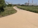
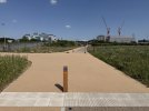
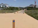
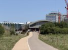
The first part of the path through the country park to the station has been opened recently. Here are some photos showing the combined foot/cycle path.
It seems to have a very soft surface making it quite hard work to cycle on…
I wonder if that's a) an oversight in the design b) a result of the hot weather c) a deliberate design choice to slow cyclists down in a busy mixed-use area
I wonder if that's a) an oversight in the design b) a result of the hot weather c) a deliberate design choice to slow cyclists down in a busy mixed-use area
The surface for the mixed-use area matches the surface used for the pedestrian side of the split-use path, so possibly it's less of (c) but more of a deliberate choice to prioritise the pedestrian-friendly surface.