• Our new ticketing site is now live! Using either this or the original site (both powered by TrainSplit) helps support the running of the forum with every ticket purchase! Find out more and ask any questions/give us feedback in this thread!

Cambridge South new station opening

neill

Member
Joined
4 Apr 2012
Messages
193
One thing that concerns me as a local resident is that there does not appear to be any street lights on the path to the Western entrance through Hobson's Park.
Indeed. There are marker lights embedded in the path but that is no the same as street lighting. A compromise on encroachment into the park I suspect.

Using the eastern exit and then the busway would mean a fully lit route.
 
Sponsor Post - registered members do not see these adverts; click here to register, or click here to log in
R

RailUK Forums

William3000

Member
Joined
24 May 2011
Messages
593
Location
Cambridgeshire
Agreed it seems to be smaller on this side than the one facing the park but maybe that is an illusion.

There is now a totem on the street to make it a bit more obvious where the station is for those coming from the hospital.

I am hoping we will shortly see a run round all the local signage that says ‘station’ with at least an update to the direction arrows.
Indeed and I wonder what road signs in the area will say since Cambridge (Central) is frequently signed in the area as ‘Station’ with the twin arrows.

== Doublepost prevention - post automatically merged: ==

Cambridge is a multi-nodal city. The area around the old station is what Americans or Australians would call the Central Business District.


It has taken almost 200 years, but now it turns out to be a good thing. It is hard to see how the transformation of the area around the old station in the last 20 years could have happened if it had been close to the colleges.

== Doublepost prevention - post automatically merged: ==


Does that include the Biomedical Campus?
Agreed - what seemed a curse was actually an opportunity. Had the railway station been located right in the historic core, there would’ve been much less potential to build large office blocks etc.

== Doublepost prevention - post automatically merged: ==

For most people Mill Road is at least 10 minutes walk from the station, and more if they want to go beyond the end of Devonshire Road, or if they have to get to or from the island platform.

In half an hour there is time to get to Mill Road and time to get back but no time to do anything when you are there.

To get us back on topic, Cambridge South has the AZ Hub and the Papworth Cafe nearby, plus Stir a bit further away. But the nearest supermarket is probably the Sainsburys the other side of Hobsons Park.
I presume the station building has some areas reserved for retail space - small coffee shop, mini convenience supermarket etc?

== Doublepost prevention - post automatically merged: ==

One thing that concerns me as a local resident is that there does not appear to be any street lights on the path to the Western entrance through Hobson's Park.
The existing cycleway alongside the busway heading west has street lights
 
Last edited:

TheDavibob

Member
Joined
10 Oct 2016
Messages
430
Indeed and I wonder what road signs in the area will say since Cambridge (Central) is frequently signed in the area as ‘Station’ with the twin arrows.
Cycling directions in the North still ambiguously sign to "station" and point towards "Central" at locations where signs to Cambridge North would make more sense, so I'm not particularly optimistic about a quick switch. Perhaps signs for motorists would be quicker to change, but conversely I imagine there'll be no desire to sign any motorists to Cambridge South unless they're already in the Campus itself as a main purpose of the station is to reduce road traffic in the area.
 

hedge nerd

New Member
Joined
28 Jul 2025
Messages
4
Location
Cambridge
Indeed. There are marker lights embedded in the path but that is no the same as street lighting. A compromise on encroachment into the park I suspect.

Using the eastern exit and then the busway would mean a fully lit route.
And a quite a bit of a detour.

== Doublepost prevention - post automatically merged: ==

[... snip ...]

The existing cycleway alongside the busway heading west has street lights
They are not exactly adjacent, there is up to ~50ft between them in some places, with trees between the two paths in some locations.
 

mr_moo

Member
Joined
7 Sep 2009
Messages
647
Location
Cambridgeshire
I presume the station building has some areas reserved for retail space - small coffee shop, mini convenience supermarket etc?
There's a areaosnably sized area within the Hobsons Park side building that is reserved for a separate unit of some kind. When I left the project (about 10 months ago now!) no decision had been made re what or who was to occupy it. Note - It opened onto the park, with no opening into the station as it was intended as a community serving fscility, not just a rail passenger facility, although the wall between the unti and the station is of a kind where cutting a serving hatch into it would not be hard and there's a place to do that if anyone ever wanted to.

== Doublepost prevention - post automatically merged: ==

Re the lights on the path - indeed, there are no dedicated lights provided for this. There was work done to ensure the path was sufficiently illuminated by the small lights provided plus the street lights from the busway, but there was no intention to provide full lighting levels as you would get on a properly lit path.
 

vuzzeho

Member
Joined
11 Apr 2022
Messages
663
Location
London
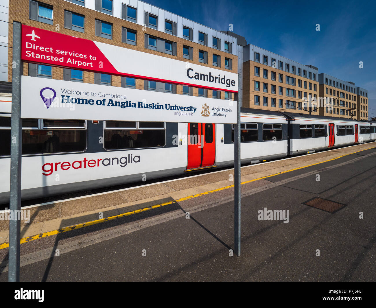
Here are some photos taken last week from the reopened busway bridge, including the notably not Greater Anglia branded signage.
Right, so despite the various articles and press release stating it'll be the first GBR branded station, they aren't even using GBR signs! The signage uses GA's current (former? unsure what to call it now) signage style, with the diagonal red and Transport UK's font - with no GA logo. Are they going to just replace all the signs at the station?

Example included - a stock photo of Cambridge station's GA-style sign - back pre-Aventra! vs a GBR-style sign at London Euston.

Photo credits: Alamy and 'Transport Signs' on LinkedIn.

greater-anglia-train-at-cambridge-raiway-station-P7J5PE.jpg
1772094889541
 

Backroom_boy

Member
Joined
28 Dec 2019
Messages
582
Location
London
Has there ever been a plan to four-track from Shepreth junction all the way to Cambridge? Seems like half of the distance will be four-track when Cambridge South opens and it could help isolating the two main lines from the south into Cambridge.
 

Brubulus

Member
Joined
13 Oct 2022
Messages
974
Location
Cambridge
Has there ever been a plan to four-track from Shepreth junction all the way to Cambridge? Seems like half of the distance will be four-track when Cambridge South opens and it could help isolating the two main lines from the south into Cambridge.
Yes there is as part of EWR, the issue is the Long Road bridge which will need to be rebuilt.
 

Steve Harris

Member
Joined
11 Dec 2016
Messages
1,193
Location
ECML
In half an hour there is time to get to Mill Road and time to get back but no time to do anything when you are there.
That's your opinion.
However, I have managed to walk from the station to a shoo on Mill Road and bought provisions before catching a train out of Cambridge 29 minutes later !

It really depends if your a fast walker or not.
 

neill

Member
Joined
4 Apr 2012
Messages
193
Yes there is as part of EWR, the issue is the Long Road bridge which will need to be rebuilt.
I think the last prior proposal was as part of the Cambridge South works but they were able to drop it and still meet the service requirements.

To the south of Cambridge South land take is required near to a scheduled monument to four track and there needs to be a strong justification for that.
 
Last edited:

Steve Harris

Member
Joined
11 Dec 2016
Messages
1,193
Location
ECML
Yes there is as part of EWR, the issue is the Long Road bridge which will need to be rebuilt.
Indeed.

Detail is contained in the latest consultation on the EWR website. Personally I can't see EWR happening in my lifetime, but if it does happen it will cause chaos as EWR are proposing a full road closure to replace the bridge. (Perhaps another Oxford in the making!?)
 

Magdalia

Established Member
Joined
1 Jan 2022
Messages
7,299
Location
The Fens
I think the last prior proposal was as part of the Cambridge South works but they were able to drop it and still meet the service requirements.
The original proposal for Cambridge South included 4 tracks from Shepreth Branch Junction to Cambridge but was scaled back to what we have now as part of the consultation process.

Yes there is as part of EWR

This is what the EWR consultation document says about 4 tracks from Shepreth Branch Junction to Cambridge:

The existing two‑track WAML cannot accommodate the additional EWR services. We would need to widen the railway from two tracks to four tracks, from Shepreth Junction northwards, through to Cambridge station.

the issue is the Long Road bridge which will need to be rebuilt.
This is what the EWR consultation document says about Long Road:

At Long Road the existing A1134 bridge would be replaced with a wider bridge to accommodate the extra tracks. We have tested multiple options for how best to replace this bridge and add the new tracks beneath, given that Long Road is a key route within Cambridge and the West Anglia Main Line is a busy rail corridor. We have taken the decision to fully close the road to rebuild the bridge for a period of six to thirteen weeks. We would use techniques such as off‑site pre‑fabrication to reduce disruption during the works. In addition, we’re developing a wider plan for the local area, including scheduling the works during school holidays when traffic is lower, working with the local authority to understand and coordinate other planned works in the area, and working with emergency services to ensure continuity of operations.

School traffic is one of the key factors in Cambridge traffic congestion. Traffic disruption will be minimised of the closure can be confined to a 6-7 week school summer holiday period.
 

rmHawk765

Member
Joined
8 Apr 2025
Messages
708
Location
ECML South
It's like 50 shades of grey
The signage sure is incredibly bland. It looks rubbish without a double arrows or anything, that empty space above the 'for Hospitals and Biomedical Campus' looks hideous. And we don't even know how exactly services will be branded under GBR... I've nothing against the same branding everywhere but at least make it more interesting make it not look cheap! The rather colourful 80x mockup would be perfect on signage in my opinion.

Edit: Just saw this is GA branding, as I suspected due to the red line. Nonetheless it looks pretty awful IMO.
 
Joined
13 Jan 2024
Messages
498
Location
Cambridge
Of course I did. More times than you could shake a stick at. Mill Road is not close to Cambridge station unless you know.
It's really close if you walk through the car park

== Doublepost prevention - post automatically merged: ==

The centre of Cambridge is moving ever closer to Cambridge station. Such a busy area now.
Yeah this was my case study in my Geography GCSE. Cambridge has had huge economic growth in the last few years, and that's mainly evidenced by the area around the station. We said that Cambridge North and Cambridge South were a way to help with traffic congestion, which was the major negative consequence of rapid economic growth. The centre of Cambridge will always be around the Grand Arcade in my eyes though, even with the development around the station.
 
Last edited:

sharpener

Member
Joined
4 Oct 2018
Messages
371
The centre of Cambridge will always be around the Grand Arcade in my eyes though, even with the development around the station.
I don't know about "always". I would have said Great St Mary's/Senate House. OH says Market Square. There are arguments for all of these and more.

The Grand Arcade is a relative newcomer, the area was in living memory grotty cobbled alleys like Falcon Yard (notable for its MacFisheries fish shop and associated smell) https://capturingcambridge.org/museum-of-cambridge/museum-exhibit-stories/falcon-yard/.
 
Last edited:
Joined
13 Jan 2024
Messages
498
Location
Cambridge
The Grand Arcade is a relative newcomer, the area was in living memory grotty cobbled alleys like Falcon Yard (notable for its MacFisheries fish shop and associated smell) https://capturingcambridge.org/museum-of-cambridge/museum-exhibit-stories/falcon-yard/.
Not in my living memory though

== Doublepost prevention - post automatically merged: ==

Yes my usual route passed our messroom.
Is that the one off the end of platform 6?
 

Backroom_boy

Member
Joined
28 Dec 2019
Messages
582
Location
London
To the south of Cambridge South land take is required near to a scheduled monument to four track and there needs to be a strong justification for that.
I don't doubt you at all, but i can't see where this monument would be on Google maps?
 

William3000

Member
Joined
24 May 2011
Messages
593
Location
Cambridgeshire
I don't know about "always". I would have said Great St Mary's/Senate House. OH says Market Square. There are arguments for all of these and more.

The Grand Arcade is a relative newcomer, the area was in living memory grotty cobbled alleys like Falcon Yard (notable for its MacFisheries fish shop and associated smell) https://capturingcambridge.org/museum-of-cambridge/museum-exhibit-stories/falcon-yard/.
My understanding is that the official centre of Cambridge - the point at which distances have been historically been measured is the doorway to the western entrance to Great St Mary’s church tower
 

Netwrox

Member
Joined
15 May 2023
Messages
25
Location
Cambridge
School traffic is one of the key factors in Cambridge traffic congestion. Traffic disruption will be minimised of the closure can be confined to a 6-7 week school summer holiday period.
They closed Long Road during the school summer holiday of (I think) 2006 in order to construct the guided bus maintenance track underpass. So there's precedent for this. Although you wouldn't have had to factor in railway closures into that work.
 

Magdalia

Established Member
Joined
1 Jan 2022
Messages
7,299
Location
The Fens
Here is the entry on the register:

https://historicengland.org.uk/listing/the-list/list-entry/1006891?section=official-list-entry
Described as “Site revealed by aerial photography W of White Hill Farm”
Thanks for finding and sharing this. The Historic England link has a pdf map which I have downloaded!

This is what the EWR consultation says:

Our proposals have been developed to limit the amount of land required on the west side of the railway, reducing impacts on the scheduled monument in this area. The land designated as a scheduled monument would be taken out of agricultural use to better preserve the buried archaeology and offer opportunities for increasing public open space and connectivity.

The scheduled monument is not the only constraint at this location. On the east side of the line is the Nine Wells nature reserve with chalk springs that feed Hobsons Brook. Until 50 years ago this was a site of special scientific interest, but unfortunately what made it interesting died out when the springs dried up in the 1976 drought.

There are also issues with the DNA cycle path, which runs adjacent to the railway, and proposals for a busway, both on the east side.

They closed Long Road during the school summer holiday of (I think) 2006 in order to construct the guided bus maintenance track underpass. So there's precedent for this. Although you wouldn't have had to factor in railway closures into that work.
Thanks, I'd forgotten this. Cambridge traffic in 2006 was very different from 2026, but, on the other hand, alternative places to cross the railway were more limited.
 

Netwrox

Member
Joined
15 May 2023
Messages
25
Location
Cambridge
Thanks, I'd forgotten this. Cambridge traffic in 2006 was very different from 2026, but, on the other hand, alternative places to cross the railway were more limited.
Indeed. Don't think Addenbrookes Road existed then. So Long Road would have been the main road access between the M11 and the hospital site. And no guided bus or associated cycle route either.
 

MikeWM

Established Member
Joined
26 Mar 2010
Messages
4,930
Location
Ely
My understanding is that the official centre of Cambridge - the point at which distances have been historically been measured is the doorway to the western entrance to Great St Mary’s church tower

This is correct - there is a small circular plaque to the right (facing into the Church) of the west door of the Church that explains this. The University also still uses this for measuring distances for the purpose of determining whether students satisfy residency requirements.

As a fairly long-term resident of the area, if you were to ask me I'd say without much doubt that it feels that the centre is the vaguely rectangular area bounded by Market Street, Sidney Street, Petty Cury, St Mary's Passage, Senate House Hill.

The economic centre moving southwards is almost certainly due to the massive expansion of the Addenbrookes site over the last couple of decades, which does show the great need for Cambridge South. Good that is is *finally* about to be open.
 

Magdalia

Established Member
Joined
1 Jan 2022
Messages
7,299
Location
The Fens
The economic centre moving southwards is almost certainly due to the massive expansion of the Addenbrookes site over the last couple of decades, which does show the great need for Cambridge South. Good that is is *finally* about to be open.
The Cambridge Biomedical Campus website has a timeline, see here:


The Biomedical Campus hasn’t always been such a prominent hub of medical research and health science. Our story started in 1951, and over more than 70 years we’ve come a long way.

Don't think Addenbrookes Road existed then.

Go to 2013 and there is an aerial picture of Addenbrookes bridge surrounded by fields.

This picture on flickr shows the Addenboookes and busway bridges under construction in 2008.


As a fairly long-term resident of the area, if you were to ask me I'd say without much doubt that it feels that the centre is the vaguely rectangular area bounded by Market Street, Sidney Street, Petty Cury, St Mary's Passage, Senate House Hill.

I'd make this a bit bigger, but not much. The key point is that the town centre is small and hemmed in by more than a dozen colleges.
 

wagnaga

Member
Joined
30 Nov 2019
Messages
88
Location
East Anglia
When they do replace the bridge will rail services terminate at Cambridge station from the north and east and Cambridge South from the south?
 

Magdalia

Established Member
Joined
1 Jan 2022
Messages
7,299
Location
The Fens
When they do replace the bridge will rail services terminate at Cambridge station from the north and east and Cambridge South from the south?
The signalling is there to do it, the main obstacles will be overhead line isolations and rail replacement bus access.
 

William3000

Member
Joined
24 May 2011
Messages
593
Location
Cambridgeshire
When they do replace the bridge will rail services terminate at Cambridge station from the north and east and Cambridge South from the south?
No - the replaced bridge will simply allow 4 tracking from Shepreth branch junction to Cambridge station. No trains will terminate at Cambridge South and in the future the aim is to minimise the number of trains terminating at Cambridge but there are still two south facing and two north facing bay platforms if required
 

Backroom_boy

Member
Joined
28 Dec 2019
Messages
582
Location
London
Don’t think it is shown on google maps.

Here is the entry on the register:


Described as “Site revealed by aerial photography W of White Hill Farm”
Thanks. Don't really understand what it is unless the monument is the actual field shape/perimeter?

== Doublepost prevention - post automatically merged: ==

No - the replaced bridge will simply allow 4 tracking from Shepreth branch junction to Cambridge station. No trains will terminate at Cambridge South and in the future the aim is to minimise the number of trains terminating at Cambridge but there are still two south facing and two north facing bay platforms if required
I think what was meant was in the 2/3 months or so the bridge was closed would services terminate at Cambridge in the north and Cambridge South from the south. My guess would be yes.
 

Top