• Our new ticketing site is now live! Using either this or the original site (both powered by TrainSplit) helps support the running of the forum with every ticket purchase! Find out more and ask any questions/give us feedback in this thread!

A British "Taktfahrplan" - Feasible or Fantasy?

Status
Not open for further replies.

NCT

Established Member
Joined
18 Apr 2025
Messages
2,334
Location
London
One aspect I would like add to the question of „Swiss or dutch-style“ is rail‘s competitive position vs the private car.

On a 30-minute base interval after all, if you include a 5 minute minimum connecting time (which needs infrastructure precautions by itself), in a Dutch-style system, your connecting time will range between 5 and 35 minutes, ie 20 minutes on average.

In a place like Switzerland, and indeed Austria, where rail services are generally slow and car trips rather fast - because road congestion is often not that much of an issue - having an average connection time of 20 minutes - or a multiple thereof if you have to change more than once - will significantly reduce rail‘s competitiveness.

While I am not an expert on Dutch road traffic in the slightest, I imagine that the equation, due to slow roads in the central parts of the country, will be very different. It certainly will be in most of England, where in addition intercity rail is - sometimes very - fast.

The Netherlands has fast roads and they are not shy about building motorways. For suburb to suburb traffic road can be competitive. However, their towns and cities are designed where walking and cycling are at the top of the pyramid and driving right in is discouraged and indeed difficult. Given the highly urbanised nature of the country, a lot of trips will have at least one trip end in such 'car hostile' environments, so the railway has a captive market. Britain has a very similar urban density to the Netherlands and the towns and cities are generally going the right way in becoming less car centric (still much work to do).

Train speed wise, the Netherlands' ruling 140km/h and Britain's 80-100mph (outside of the inter-city main lines) are similar.

The major Dutch nodes have combined frequencies of 4tph on most arms, and only a minority of passengers change between specific half-hourly services. In Switzerland stations only need to be a bit big for interchanges to become 20 minutes (xx50 arrival for xx10 departure). I suspect, when you look at actual interchanges being made the average interchange time in the Netherlands won't be that much different to that in the Switzerland. This is again where the UK is far more similar to the Netherlands than it is to Switzerland.

Take Derby for example, it has 4tph to Nottingham, 4tph to Birmingham and 4tph to Sheffield. It really doesn't matter which part of the hour any of these services run (as long as they are regular and symmetrical). It also doesn't matter which part of the hour the Matlock or Crewe services run (you would connect them with each other if possible, but relatively few passengers would connect between these services).
 
Sponsor Post - registered members do not see these adverts; click here to register, or click here to log in
R

RailUK Forums

Joined
5 Aug 2015
Messages
913
Location
Norfolk
I strongly disagree with American-style grids which create car dependency. Rather I’d plan estates with maximum walkability, where cul-de sacs for cars continue as a footpath to avoid pedestrians having to double back. Private vehicles would only be able to access via a single access road, while buses could use bus-only roads between different estates to provide seamless travel between them.
There's nothing inherently car dependant about grid formats. They're associated with US city design because the majority of their urban areas spawned from the late 19th century onwards (still pre-car). Grid formation is sort of the norm for terraced housing in Britain from around the same time and earlier. Cul-de-sacs are more inherently car dependant because they artificially lengthen walking times and decrease density since houses are basically rectangular in shape. You can crosslink with pedestrian paths in cul-de-sacs but, as others have mentioned, Secured by Design would have a problem with that (although I for one believe we give Secured by Design way too much of a say over what out public realm looks like).
What I'd argue for is grid pattern neighbourhood but with strategic traffic filtering features (curbs perhaps a bollard) for car traffic, effectively creating cul-de-sac limitations for cars only while biking and walking can use the whole grid as desired. This may sound like splitting hairs, but the grid format allows for much better density making walking trips easier and pedestrian only streets (or sections of streets) would be a similar width to those that the cars can use meaning the Secured by Design can't argue you've made them a dank little alley way. In fact you can use those automatic retractable bollard equipment meaning emergency vehicles can get over into the pedestrianised areas
 

PTR 444

Established Member
Joined
22 Aug 2019
Messages
2,647
Location
Wimborne
There's nothing inherently car dependant about grid formats. They're associated with US city design because the majority of their urban areas spawned from the late 19th century onwards (still pre-car). Grid formation is sort of the norm for terraced housing in Britain from around the same time and earlier. Cul-de-sacs are more inherently car dependant because they artificially lengthen walking times and decrease density since houses are basically rectangular in shape. You can crosslink with pedestrian paths in cul-de-sacs but, as others have mentioned, Secured by Design would have a problem with that (although I for one believe we give Secured by Design way too much of a say over what out public realm looks like).
What I'd argue for is grid pattern neighbourhood but with strategic traffic filtering features (curbs perhaps a bollard) for car traffic, effectively creating cul-de-sac limitations for cars only while biking and walking can use the whole grid as desired. This may sound like splitting hairs, but the grid format allows for much better density making walking trips easier and pedestrian only streets (or sections of streets) would be a similar width to those that the cars can use meaning the Secured by Design can't argue you've made them a dank little alley way. In fact you can use those automatic retractable bollard equipment meaning emergency vehicles can get over into the pedestrianised areas
I hadn’t thought about that. From a safety perspective, you are quite right that cul-de-sacs and pedestrian paths aren’t the best choice for reducing crime.

Grid patterns in the way you describe do work quite well, especially if some roads in that grid are bollarded to give them more of a cul-de-sac feel. I could see many 19th century housing developments being adapted in this way.

You could also allocate some roads in that grid exclusively for bus use, particularly if they don’t have property frontages directly adjoining them. As an example, you could have a grid estate where all horizontal roads have terraced housing, while vertical roads alternate between private vehicle and public transport access routes.
 

Sorcerer

Established Member
Joined
20 May 2022
Messages
2,207
Location
Liverpool
I know - that was precisely my point... a timetable alone would do nothing without these other things. Of course we could do it - they are, to me, the real drivers behind transforming towards the transit mindset of these example countries.
Having an integrated timetable would make rail travel easier and more convenient that road travel, but I do agree with you about some of the other things. I think a national railcard available to any regular rail user (as in not a veteran, disabled, or travelling with family or as a constant couple) would be a great step too. I think the only major issue is that it would encourage more travel when the railway can't squeeze any more people onto the network.
Warrington and Huddersfield were my examples of equidistant / polycentric places, not the nodes themselves of course. My point was that they are rare exceptions, and most places are in the orbit of one place. Our economic activity is not as distributed as the Randstad.
I think I know what you mean, that most people will be travelling to London because economic activity is heavily centralised there. This is where I think a British Takt would need to have multiple network pulses rather than a nationwide one like Switzerland. Not every place can have a direct train to London, but optimal connectivity is the second best thing from an ideal world standpoint. Arguably the most pragmatic.

== Doublepost prevention - post automatically merged: ==

Train speed wise, the Netherlands' ruling 140km/h and Britain's 80-100mph (outside of the inter-city main lines) are similar.
Crucially I think this is where HS2 and NPR could've assisted in enabling a British Taktfahrplan. With the main trunk routes being mixed-traffic of fast intercity and slower regional trains it's hard to have an integrated timetable without either slowing down the fast trains or speeding up the slow ones. It wouldn't be impossible by any stretch, but considerably more difficult compared to having dedicated high-speed corridors alongside a classic network with uniform speeds.
 

35B

Established Member
Joined
19 Dec 2011
Messages
5,582
I hadn’t thought about that. From a safety perspective, you are quite right that cul-de-sacs and pedestrian paths aren’t the best choice for reducing crime.

Grid patterns in the way you describe do work quite well, especially if some roads in that grid are bollarded to give them more of a cul-de-sac feel. I could see many 19th century housing developments being adapted in this way.

You could also allocate some roads in that grid exclusively for bus use, particularly if they don’t have property frontages directly adjoining them. As an example, you could have a grid estate where all horizontal roads have terraced housing, while vertical roads alternate between private vehicle and public transport access routes.
I grew up in one such area - the "Southfields Grid" in SW18. Built 1900-1905-ish, nearly demolished in the late 1970s and now ridiculously expensive.

It's bounded by main roads that take the through traffic, while walking to shops & services is easy - the two end points of Southfields and Wimbledon Park stations are about 20 minutes walk apart. The streets are just wide enough for buses (they use one block for turning Wimbledon tennis shuttle buses) but public transport goes round the edge of the area.
 

The Ham

Veteran Member
Joined
6 Jul 2012
Messages
12,046
Crucially I think this is where HS2 and NPR could've assisted in enabling a British Taktfahrplan. With the main trunk routes being mixed-traffic of fast intercity and slower regional trains it's hard to have an integrated timetable without either slowing down the fast trains or speeding up the slow ones. It wouldn't be impossible by any stretch, but considerably more difficult compared to having dedicated high-speed corridors alongside a classic network with uniform speeds.

HS2 phase 1 services could add 5% to the current national passenger km values.

The impact of the reduction of existing passenger km from the existing network could add around 2% to the national passenger km values (as a lotof the new travel is likely to be shorter distances)

Whilst those numbers sound low, as rail is measured in billions of km's that's potentially quite a lot of extra passengers.

They are unlikely to all come from stations along the WCML, and as such could act as an opportunity to use capacity to create extra connections to the main lines without adding lots of direct services from everywhere to London. This could be done by increasing frequencies to the mainline (2 or 3tph) to connect with decent mainline frequencies rather than 2 random towns getting a new hourly direct service to London.
 
Joined
5 Aug 2015
Messages
913
Location
Norfolk
Grid patterns in the way you describe do work quite well, especially if some roads in that grid are bollarded to give them more of a cul-de-sac feel.
Yeah it's a grid pattern for active travel but car traffic can only use it as a kind of angular cul-de-sac
I could see many 19th century housing developments being adapted in this way.
This is basically what LTN schemes are. Or at least a major kind of thing that they do - adapting old grid pattern streets to remove rat-runs for cars
You could also allocate some roads in that grid exclusively for bus use, particularly if they don’t have property frontages directly adjoining them. As an example, you could have a grid estate where all horizontal roads have terraced housing, while vertical roads alternate between private vehicle and public transport access routes.
Potentially? Nothing wrong with having people's front doors adjoin to a bus line. Buses aren't especially disruptive in the way that consistent car traffic is. Another thing to think about is building new developments with coherent centres were there are some retail presence that is the focal point for the new development, and it's there where'd you have the main public transport access - whereas the main car access to the area is at the fringes furtherst away from each "high street" or "square/plaza".
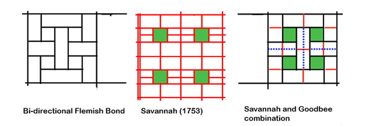
There are also lots of interesting variations of grid design to consider, like the old Savannah model that has small parks weaved throughout what could be quite dense mid-rise apartments
Goodbee52.jpg
 

cle

Established Member
Joined
17 Nov 2010
Messages
5,666
I grew up in one such area - the "Southfields Grid" in SW18. Built 1900-1905-ish, nearly demolished in the late 1970s and now ridiculously expensive.

It's bounded by main roads that take the through traffic, while walking to shops & services is easy - the two end points of Southfields and Wimbledon Park stations are about 20 minutes walk apart. The streets are just wide enough for buses (they use one block for turning Wimbledon tennis shuttle buses) but public transport goes round the edge of the area.
I another, between Salusbury Road and Kilburn High Road in NW6 - rough in my youth, now very desirable, 7 figure houses, especially the QP side. And transport options at either end, with grids of terraced housing in between. Not as uniform as yours, or the Harringay ladder.

I think I know what you mean, that most people will be travelling to London because economic activity is heavily centralised there. This is where I think a British Takt would need to have multiple network pulses rather than a nationwide one like Switzerland. Not every place can have a direct train to London, but optimal connectivity is the second best thing from an ideal world standpoint. Arguably the most pragmatic.
We do equally want to encouraging rail commuting to non-London places - I would argue that the 'regions' are way more car dependent in their commuting modes - driving most rail into car choked places like Bristol or Leeds - (Liverpool, Glasgow, Birmingham are already good - Manchester only due to the met, rail still a bit poor) - and smaller places like Exeter, Norwich, Chester, York - which are still buzzing with activity - should be a priority.

I used to commute to Hilversum. Many employers are at Schiphol, as is the mall (same as ZRH station) - we didn't quite plan for this and things like the M4 corridor are adjacent to LHR but wildly not-integrated with it. Could we one day have a business park at T5, or do more at Hatton Cross/T4?

Jobs are the real key to polycentricity - and it's not just A city centre vs B city centre, but business parks, science parks, campuses, malls - all of the things not in centres. Cambridge, especially once South opens, might be an interesting microcosm of this, as the options for rail travel diversify there.
 

HSTEd

Veteran Member
Joined
14 Jul 2011
Messages
20,375
I will note that the cost of running a bus is defined to a large agree by the time and distance taken to run it.

Which implies a cost per journey related to the number of housing units the bus passes per mile and per hour.
So you could probably have a relatively low density area that is inexpensive to serve with public transport like buses by having relatively long thin plots.

You could have a lot of houses passed by buses large plots and less road needed all at the same time.

All the space and comfort advantages of suburbia but with inexpensive public transport too.
Same thing could be done with things like automated light metros in newbuild, which cuts your public transport staff costs
 

PTR 444

Established Member
Joined
22 Aug 2019
Messages
2,647
Location
Wimborne
Yeah it's a grid pattern for active travel but car traffic can only use it as a kind of angular cul-de-sac

This is basically what LTN schemes are. Or at least a major kind of thing that they do - adapting old grid pattern streets to remove rat-runs for cars

Potentially? Nothing wrong with having people's front doors adjoin to a bus line. Buses aren't especially disruptive in the way that consistent car traffic is. Another thing to think about is building new developments with coherent centres were there are some retail presence that is the focal point for the new development, and it's there where'd you have the main public transport access - whereas the main car access to the area is at the fringes furtherst away from each "high street" or "square/plaza".
There are also lots of interesting variations of grid design to consider, like the old Savannah model that has small parks weaved throughout what could be quite dense mid-rise apartments
Goodbee52.jpg
The Savannah and Goodbee combination looks intriguing. I imagine the dotted blue lines as bus-only roads, red as residential roads and black as major thoroughfares.
 

JohnofWessex

Member
Joined
3 Jan 2026
Messages
157
Location
frome
I suggest that whatever else we do there needs to be pressure to ensure that services are reliable and punctual

One of the reasons why every farm gate wants a direct train to London is the perceived unreliability of connections especially where services are not that frequent

What was interesting was one evening when I was the trainee driver on the last Poznan-Wolsztyn train the train crew were getting very unhappy as departure was delayed due to waiting for the Police to come and remove a drunk - there is a culture of timekeeping that we need here
 

Bletchleyite

Veteran Member
Joined
20 Oct 2014
Messages
113,832
Location
"Marston Vale mafia"
So my view hasn't really changed since this last came up.

Our network is probably too complex and with too many different demands for a Grossbritannientakt to work. An example is the Marston Vale - just after COVID they set up a really nice Takt style timetable for that - DMU arrives at Bletchley, a full cycle of fast and slow departures each way, DMU leaves again. On paper it's perfect. But in fact the Marston Vale line mostly stands alone and is used (to the extent it's used by anyone) primarily for local journeys, and it was more convenient to shift the afternoon departures to fit with the school times, the only time it's ever busy. So the Takt was broken.

However I do think some Takt-like features can and should be introduced, such as more consistent stopping patterns (already in place on the WCML South) and alternating through services and good connections. Barrow and Windermere are an example of something we actually used to have - in alternating hours you had a through Windermere with a connection for Barrow and beyond serving all stations at Lancaster, and in the other hour a through semifast Barrow and a Windermere shuttle. Sorting out that mess back to something closer to that would certainly be of benefit. Similarly where a connection is useful making it actually line up properly where feasible by way of targetted infrastructure enhancements is a good thing.
 

stevieinselby

Established Member
Joined
6 Jan 2013
Messages
1,724
Location
Selby
I will note that the cost of running a bus is defined to a large agree by the time and distance taken to run it.

Which implies a cost per journey related to the number of housing units the bus passes per mile and per hour.
So you could probably have a relatively low density area that is inexpensive to serve with public transport like buses by having relatively long thin plots.

You could have a lot of houses passed by buses large plots and less road needed all at the same time.
It doesn't really work like that, because people will walk a short way to catch a bus that doesn't run down their street. So what you want to do is maximise the number of people living within, let's say, a 5 minute walk of each bus stop. To that extent, plot size is more important than plot shape – that's what determines how many houses you can pack into a given area.
 

Bletchleyite

Veteran Member
Joined
20 Oct 2014
Messages
113,832
Location
"Marston Vale mafia"
It doesn't really work like that, because people will walk a short way to catch a bus that doesn't run down their street. So what you want to do is maximise the number of people living within, let's say, a 5 minute walk of each bus stop. To that extent, plot size is more important than plot shape – that's what determines how many houses you can pack into a given area.

The optimal layout for that is "beads on a string" - i.e. 500m radius circles of development around stops. You can fill in the gaps with parkland.

You can see that having developed naturally in some places, e.g. around outersuburban Merseyrail stations and the outer Tube. Much less so in Manchester and Brum which have just sprawled.
 

The Ham

Veteran Member
Joined
6 Jul 2012
Messages
12,046
The optimal layout for that is "beads on a string" - i.e. 500m radius circles of development around stops. You can fill in the gaps with parkland.

You can see that having developed naturally in some places, e.g. around outersuburban Merseyrail stations and the outer Tube. Much less so in Manchester and Brum which have just sprawled.

Copenhagen is a good example, fingers of development with a metro along the fingers and then greenbelt between to ensure that development doesn't spraw.
 

stevieinselby

Established Member
Joined
6 Jan 2013
Messages
1,724
Location
Selby
The optimal layout for that is "beads on a string" - i.e. 500m radius circles of development around stops. You can fill in the gaps with parkland.

You can see that having developed naturally in some places, e.g. around outersuburban Merseyrail stations and the outer Tube. Much less so in Manchester and Brum which have just sprawled.
That might make sense if you are going for light rail, but buses generally stop a lot more frequently than that, usually every 300–400m, so on that basis you can have a continuous corridor about 800m wide that is served by a bus running down the middle of it, and with decent permeability you can give almost everyone a bus stop within a 500m walk.
 

zwk500

Veteran Member
Joined
20 Jan 2020
Messages
18,663
Location
Northampton
The Netherlands has fast roads and they are not shy about building motorways. For suburb to suburb traffic road can be competitive. However, their towns and cities are designed where walking and cycling are at the top of the pyramid and driving right in is discouraged and indeed difficult. Given the highly urbanised nature of the country, a lot of trips will have at least one trip end in such 'car hostile' environments, so the railway has a captive market. Britain has a very similar urban density to the Netherlands and the towns and cities are generally going the right way in becoming less car centric (still much work to do).

Train speed wise, the Netherlands' ruling 140km/h and Britain's 80-100mph (outside of the inter-city main lines) are similar.
The Netherlands is, however, 300km north-south and 190km east-west at it's widest extents. 300km gets you from London to just beyond York, and 190km gets you from London to just beyond Bristol. This is an important element - the Netherlands is very well-sized for an efficient, frequent service and isn't doesn't really have the equivalent of the Heart of Wales line or Whitby line.

That's not to say a UK Takt couldn't be made to work - although the May 18 timetable change showed just how difficult it can be to structure even a sub-national timetable around a single critical point. Standardised stopping patterns (with route numbers for unreserved trains and train numbers for reservable trains) and investment in separation of conflicting traffic flows (with *BOTH* infrastructure and service changes) would help with a number of issues. Also, close some heavy rail branches to turn them over to local light rail to avoid wasting capacity on busier sections with trains that aren't doing as much as they could be. There are 3 'cores' that really stand out as candidates for the 'taktpoint' - Crossrail (Paddington Low Level), Thameslink (Ewer Street Jn), and Castlefield (Manchester Piccadilly platforms 13/14), and of those I'd probably pick Crossrail given the level of interaction with the GEML and GWML.
(Crossrail affects Anglia, which impacts Cambridge, which impacts Thameslink hence not suggesting 2 splits).

However this will mean things like, for instance, particular towns having to deal with direct connections being broken to make it fit. And it will likely need a mix of station closures to facilitate the thresholds for node-to-node connectivity, so plenty of people will be blinded with rage from the opportunities such a plan offers. Ah well.
 

HSTEd

Veteran Member
Joined
14 Jul 2011
Messages
20,375
It doesn't really work like that, because people will walk a short way to catch a bus that doesn't run down their street. So what you want to do is maximise the number of people living within, let's say, a 5 minute walk of each bus stop. To that extent, plot size is more important than plot shape – that's what determines how many houses you can pack into a given area.
Those sorts of crowded layouts will tend to generate more other traffic however. That traffic will tend to reduce the speed of the bus service so it rapidly runs into diminishing returns unless you expend land surface on bus only routes not used to access.

The metric is probably more like number of people within a five minute walk of the bus stops that can be served by a bus per unit time.

Slower buses also make them less attractive, but that's harder to measure..

EDIT:
Lateral movement off the bus road also means bus stops have to be closer together to get the same maximum travel distance, again diminishing returns.
 
Last edited:

stevieinselby

Established Member
Joined
6 Jan 2013
Messages
1,724
Location
Selby
The Netherlands is, however, 300km north-south and 190km east-west at it's widest extents. 300km gets you from London to just beyond York, and 190km gets you from London to just beyond Bristol. This is an important element - the Netherlands is very well-sized for an efficient, frequent service and isn't doesn't really have the equivalent of the Heart of Wales line or Whitby line.
Equally, we could get clockface integrated services working across London, the south East, Midlands, south Wales, urban north-west, Yorkshire, the north-east and the Central Belt, and just leave off the very rural areas in other parts of the country that have extremely low population density. It doesn't have to be "all or nothing", it can be a journey rather than a destination, don't let perfect be the enemy of good, and any other platitudes you want to add. The unfeasibility of having a transport hub with hourly buses and trains radiating out from Dingwall shouldn't deter us from trying to make it work in Didcot.
 

Bletchleyite

Veteran Member
Joined
20 Oct 2014
Messages
113,832
Location
"Marston Vale mafia"
I don't think I would use Crossrail for the "takt point" simply because it's so frequent - high frequency services do not benefit from being in the Takt, and S-Bahn services (which it sort of is, albeit a posh one) generally aren't in the national Takt in Germany either.

I suspect your natural starting point would be Euston, being the most important intercity station in the country and on a very congested section of line, on which the current timetable is extremely efficient and hard to change.
 

The Planner

Veteran Member
Joined
15 Apr 2008
Messages
19,742
I don't think I would use Crossrail for the "takt point" simply because it's so frequent - high frequency services do not benefit from being in the Takt, and S-Bahn services (which it sort of is, albeit a posh one) generally aren't in the national Takt in Germany either.

I suspect your natural starting point would be Euston, being the most important intercity station in the country and on a very congested section of line, on which the current timetable is extremely efficient and hard to change.
I don't think you would start in one place, the network doesn't lend itself to it. Waterloo has no relevance to what happens at Euston for example.
 

Bletchleyite

Veteran Member
Joined
20 Oct 2014
Messages
113,832
Location
"Marston Vale mafia"
I don't think you would start in one place, the network doesn't lend itself to it. Waterloo has no relevance to what happens at Euston for example.

For a national Takt you have to as no line bar the Island Line is totally isolated. However I do note above that a national Takt may not be the best choice for the UK.
 

zwk500

Veteran Member
Joined
20 Jan 2020
Messages
18,663
Location
Northampton
I don't think I would use Crossrail for the "takt point" simply because it's so frequent - high frequency services do not benefit from being in the Takt, and S-Bahn services (which it sort of is, albeit a posh one) generally aren't in the national Takt in Germany either.
You'd pick the single national takt point on the basis of it being the most constrained place. If crossrail was largely independent from the GWML I'd agree with you, but it's not, because building the 5th and 6th tracks from Paddington to Heathrow wasn't ever likely to be viable.

However I could see arguments for Several other places including Blackfriars (flat junction for Thameslink), Manchester Oxford Road (due to the range of traffic feeding Castlefield), Coventry (as it's got limited platforms and the single line to Leamington), Birmingham New Street (due to the crossing moves between XC) and so on.

However whichever point you pick you would then need to intervene to services or infrastructure to ease the other constrained points.

There's also the issue of whether you build freight into the 'national takt' or just leave it to pick up the space that's left afterwards.
 

Sorcerer

Established Member
Joined
20 May 2022
Messages
2,207
Location
Liverpool
You'd pick the single national takt point on the basis of it being the most constrained place. If crossrail was largely independent from the GWML I'd agree with you, but it's not, because building the 5th and 6th tracks from Paddington to Heathrow wasn't ever likely to be viable.

However I could see arguments for Several other places including Blackfriars (flat junction for Thameslink), Manchester Oxford Road (due to the range of traffic feeding Castlefield), Coventry (as it's got limited platforms and the single line to Leamington), Birmingham New Street (due to the crossing moves between XC) and so on.

However whichever point you pick you would then need to intervene to services or infrastructure to ease the other constrained points.

There's also the issue of whether you build freight into the 'national takt' or just leave it to pick up the space that's left afterwards.
I can fee Farringdon being a potential single national takt point due to it's central location in London (the focal point of the network) and because that's also where the Up and Down directional line running switches. However trying to centre a national takt around this would be an enormous challenge, which is why I think a network of different takts might be a better option.

Manchester Oxford Road is an interesting choice too given that Piccadilly and Victoria would require either two different pulses or acting as a single pulse since both are on the TransPennine axis and the former is also on the WCML axis, though I'm not sure Oxford Road is a much better choice because of it's fewer connections to the rest of the network. Birmingham New Street would definitely be one though for both XC and WCML.
 

zwk500

Veteran Member
Joined
20 Jan 2020
Messages
18,663
Location
Northampton
Manchester Oxford Road is an interesting choice too given that Piccadilly and Victoria would require either two different pulses or acting as a single pulse since both are on the TransPennine axis and the former is also on the WCML axis, though I'm not sure Oxford Road is a much better choice because of it's fewer connections to the rest of the network. Birmingham New Street would definitely be one though for both XC and WCML.
The issue with picking up any single point is that a lot of the relationships are equally as constraining both ways. E.g. if you build the timetable around Manchester oxford Road, you are dictating the slots for trains at Water Street Jn, which dictates the slots into Victoria. Conversely, if you picked Victoria, you're dictating the slots at Water Street Jn, which dictates the slots at Oxford Road. One is not really any more obviously better than the other.

Ideally, the 'takt point' would be the single most constrained location, *after* any reasonable upgrades have been done to align journeys to the takt interval chosen (30/60 minutes) and provide platform capacity for the required volume of interchanging traffic.
 

NCT

Established Member
Joined
18 Apr 2025
Messages
2,334
Location
London
The first step in creating a takt is having a national symmetry. This means if a connection works in one direction it automatically works in the other. Is you have a combined even distribution high frequency in one direction, you are likely to have the same in the other direction. All your 'takt points' across the country should be symmetrical about 00/30 (or 15/45) independently, so it's not like there is a linear dependency from a single point.

The next step, is find where the current timetable is almost clockface, or almost 2tph (or made up of 2tph building blocks), and make the timetable perfectly clockface and perfectly 2tph.

The starting point wants to be a relatively rural location already with a semblance of a 2tph service pattern, and where inter-nodal journey times already happen to be multiples of 15 or 30 minutes. One of such oven ready corridors is Chester - Shrewsbury - Hereford - Newport. The current timetable is almost a takt, albeit a messy one centred very loosely on xx20/xx50. What's needed is to shift the entire timetable around the clockface to be symmetrical around xx00/xx30. Do that for all the TOCs and you'll suddenly find timetables from difference lines and regions mesh together much better.

Concentrated departures and arrivals and matching 'system' journey times are only critical in areas of relatively low frequencies, where the segment frequency of each speed profile of no more than 2tph.

There are places with a mixture of higher and lower frequencies where implementing a takt would be relatively straightforward. Most of the NSE region is there and thereabouts. Take Lewes, Barnham and Havant.

At Lewes, both Brighton and Eastbourne are 4tph, but Haywards Heath and Seaford are 2tph. The only thing that requires a bit of thought is ensuring Haywards Heath connects into Seaford (I think the current timetable does manage it).

The pattern at Barnham is pretty good. Most directions are combined 4tph and by virtue of frequency most connections are pretty good.

Havant is pretty good on a Saturday when the Porstmouth Direct Line fast services are half hourly all day and journeys like Fareham - London Waterloo connect well in both directions. Just need the weekday off-peak timetable to be uplifted to the Saturday level.
 

Austriantrain

Established Member
Joined
13 Aug 2018
Messages
1,812
If it were a Swiss-style Takt - and BTW, I agree that Dutch-style is more suitable for most parts of the UK, in many cases much more - I believe the original design start point would be Birmingham New Street, simply because that is very the two long distance lines (XC) that bind together the country and thus the timetable, cross. With HS2, New Street becomes much less relevant - the focal hub would probably move elsewhere, depending on the design of the post-HS2 timetable. It might be Leeds or Sheffield, because of the importance as (semi-)-LD interchange hubs. Or the Curzon/Moor-Street Hub. Swiss-style, it would never be a London terminus nor an outer rural station.

But again, if you do it Dutch-style, that question becomes much less relevant.
 
Last edited:

zwk500

Veteran Member
Joined
20 Jan 2020
Messages
18,663
Location
Northampton
If it were a Swiss-style Takt - and BTW, I agree that Dutch-style is more suitable for most parts of the UK, in many cases much more - I believe the original design start point would be Birmingham New Street, simply because that is very the two long distance lines (XC) that bind together the country and thus the timetable, cross. With HS2, New Street becomes much less relevant - the focal hub would probably move elsewhere, depending on the design of the post-HS2 timetable. It might be Leeds or Sheffield, because of the importance as (semi-)-LD interchange hubs. Or the Curzon/Moor-Street Hub. Swiss-style, it would never be a London terminus nor an outer rural station.

But again, if you do it Dutch-style, that question becomes much less relevant.
With the current limit of HS2, surely Colwich Jn becomes the Swiss-Style centre?
 

Austriantrain

Established Member
Joined
13 Aug 2018
Messages
1,812
With the current limit of HS2, surely Colwich Jn becomes the Swiss-Style centre?

Factually, very possible. It wouldn't be Swiss-style though, they would never let a "Colwich Jn"-situation arise in the first place.
 
Status
Not open for further replies.

Top