Trog
Established Member
Could be worse I once had to set in motion the building of a new sett for a dead badger.
For some strange reason it never moved in.
For some strange reason it never moved in.

Agreed. Whenever a reversal is involved, for me it's a different service.
When the Central section is built, I'm interested to see what happens in Bedford as a reversal will just be silly, but the cheapest so I should expect it I suppose
Northampton would need a reversal too surely and we have done that debate to death.


All trains that go to London do a reversal. Even all Electric trains that go to Bedford do a reversal. Its quite a common thing for trains to reverse. I think the point being here is that you might have to do it more than once.
I wouldn't use Northampton main station. I would create 2 new platforms on a different alignment headed towards Olney, but still within the town centre.
The line would miss Bletchley completely and head north to MKC. Thats my circular. You could have variations of the circular.
Lets say MKC is the starting point of main circular train -
MKC - Wolverton - Northampton - Olney - Bedford - Marston vale stop if any > MKC
A more outwardly circular -
MKC > Wolverton > Northampton > Olney > Bedford > Marston Vale stops if any > Bletchley > Bicester > Oxford > Reading
Reverse of the above.
Or Reading to Reading
Reading > Oxford > Bicester > Bletchley > MKC > Wolverton > Northampton > Olney > Bedford > Marston Vale stop if any > Bletchley > Bicester > Oxford > Reading
For me that is a comprehensive rail option.
When the East side is done, the same can be done there too.
Bedford > Cambridge > Ely > Peterborough > Leicester > Bedford
Before you argue this is all pie in the sky. I know that. But if railways are to be a viable option in my neck of the woods, these options need to be made a reality. If people would have left railways alone in the 60's this would have been easily implemented now.
And if you wanted to huge circular east to west from Norwich/Ipswich to Reading that could be done as well.
Did we discuss the Technical Summary report Network Rail published in July anywhere? Apologies if so.
Link via http://www.networkrail.co.uk/east-west-rail/ look for Technical Summary Report July 2016 on the right, or direct (<1MB.)

I think this is the forecast report whose non-appearance was being discussed in March, around post #559, but only from the perspective that it was unlikely to be published in May as had been reported, and would probably be around July.
Looks like the post was on the money then...
Did we discuss the Technical Summary report Network Rail published in July anywhere? Apologies if so.
Link via http://www.networkrail.co.uk/east-west-rail/ look for Technical Summary Report – July 2016 on the right, or direct (<1MB.)
Why didn't they just build Milton Keynes with Bletchley at its centre? Bletchley centre was practically demolished anyway.
Thanks, I'd forgotten the sequence. Whatamistakeatamakea. Could there not be a triangular arrangement at Bletchley?When MK was planned, railways were deemed to be old and slow, and the future was going to be the private car. The main station wasn't built until more than a decade after the first developments.

Thanks, I'd forgotten the sequence. Whatamistakeatamakea. Could there not be a triangular arrangement at Bletchley?
When MK was planned, railways were deemed to be old and slow, and the future was going to be the private car. The main station wasn't built until more than a decade after the first developments.

Have a quick glance through the technical summary it appears that the favoured route (C2-2) would not give any eastbound connection from Bedford Midland. If Bedford was not to be part of a through route I'd hoped that at least some trains from the West would reverse a Bedford Midland and continue East, but it look like that's not possible with the chosen route. Or am I missing something?
The key enabler here is Bedford.
Not a fan of Bedford Parkway, not a fan of relocated St Johns (as I've said quite a few times)
MarkyT indeed had the best idea by a mile
For me, the only other option is up and round the top of Bedford, which someone said wasn't possible for some strange non-reason
Surely they should be looking at Bedford stations options more closely than the actual corridors because they either become enabled or disabled depending on the choice of station site/orientation
but the station is well placed for the business districts/ large office blocks.
it is even worse than pie in the sky! It is never going to happen and is barely worth shooting down as it is so outlandish and would be a staggering waste of public ( or even private!) money.

MK station is very well placed right at the centre of MK. The problem is that it isn't well placed for the railway network. Hence the suggestion that MK should have been centred on Bletchley station instead.
Did we discuss the Technical Summary report Network Rail published in July anywhere? Apologies if so.
Link via http://www.networkrail.co.uk/east-west-rail/ look for Technical Summary Report July 2016 on the right, or direct (<1MB.)
Spending £1000 million on a new line from Bedford to Cambridge with no direct connection between the two cities is nonsensical. A north-to-east curve south of Bedford is not mentioned with option C2-2 and looks to be difficult.
Option C1-9 via Bedford Midland is the best. No need for separate Oxford-Bedford or Bedford-Cambridge services and some of the extra time taken by serving Bedford Midland could be saved by getting rid of the split-level ECML interchange station in the middle of nowhere, in fact a complete waste of money wherever it might be. A north-to-east curve near the ECML crossing would be much more useful.

Have a quick glance through the technical summary it appears that the favoured route (C2-2) would not give any eastbound connection from Bedford Midland. If Bedford was not to be part of a through route I'd hoped that at least some trains from the West would reverse a Bedford Midland and continue East, but it look like that's not possible with the chosen route. Or am I missing something?
The people planning MK weren't overly interested in the railways, even though the WCML ran slap bang through the middle, but that disinterest extended to other aspects of transport, with no decent roads almost to this day out of the town in any direction other than on the same London-Northampton-Midlands axis as the WCML. Even traffic using the A421 to Bedford was still being funnelled into a single carriageway on the edge of MK until recently.
I'm with you on C1-9 and the proposed ECML middle of nowhere station, but for me the answer is still to serve new parallel platforms at St Neots station. It's unfortunate they haven't considered that option as the costs of relocating Sandy station will naturally count against C1-9, favouring the predetermined preferred scheme of C2-2.
Also, looking at the maps you can see the ludicrousness of the diversion required to skirt around the should-never-have-been-built southern section of the Cambridge guided busway. It's a bus - divert it onto the roads and it'll save the creation of a bottleneck south of Cambridge with three lines funnelling into a very short section of track, and even if the WAML section does get 4 tracked, Harston to Shepreth won't be. As an added benefit, it will then eliminate the height-restricted section of the busway, so double deckers could then run throughout.
Unfortunately, a radiotelescope, the M11 and the well-patronised Trumpington Park & Ride also foul the original Sandy alignment into Cambridge, no just The Busway.
I seem to recall reading that the radio telescope isn't an issue any more as they have a new one, are happy to move or something along those lines (I think one article said they have been greatly downgraded in the last 10 or so years as better telescopes elsewhere have supplanted them). Bridging the M11 isn't an issue (and it actually looks like there may already be one in place, but the imagery has too much vegetation to tell.), and as for the Trumpington P&R...imagine how well it would do with a station providing a fast, direct service to both the central Cambridge station as well the new Cambridge North station for the science park.
People would prefer the bus. Unlike the train, it actually takes you into the City Centre of Cambridge at a higher frequency than the train could provide (and people would just drive round the M11 and A14 to get to the Science Park)
Rail park and rides are still useful. Oxford Parkway has exactly the same issue, and yet was still built.
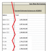
Of note, the intial costings are about £1.5-£2bn, and going via Hitchin/Letchworth is more expensive than originally thought so is not preffered.4. CONCLUSIONS FROM PHASE 2b ANALYSIS
94. The conclusion from the analysis undertaken to date is that the EWR-CS is technically feasible and would generate significant benefits for the local regional and national economies.
95. EWR-CS has clear potential to develop into a viable scheme and economic analysis suggests that Corridor C performs better than Corridor M for the following reasons:
- Corridor C provides higher benefits and revenue
- Corridor C requires lower operating costs due to lower mileage
- There is no capital cost advantage of Corridor M over Corridor C.
96. Test on long distance service options suggests running Cambridge – Birmingham or Cambridge - Manchester services is unlikely to boost the overall case for EWR CS because the additional operating costs outweigh the additional benefits and revenue. There is scope however for investigating other ways of realising some of these benefits by using lower cost interventions.
97. Diversion of existing passengers away from London radial routes onto East West Rail services, and the resulting revenue loss on existing radial services is now understood to be a minor impact. As a result, the level of crowding relief on these radial routes is very limited.
98. There is a high likelihood of EWR services generating an operating surplus.
99. The best performing routing option (C2-2) achieves a BCR of between 1.4 and 1.5, exclusive of Wider Economic Benefit (WEBs). Adjusted to include WEBs, this increases the BCR for option C2-2 to over 2.0, which falls into the Department for Transport’s “high value for money” category.
Could you say what part of the report gives you that impression?Yes, but reading the whole report gives the impression that C1-1 is prefered for other reasons, as I opined earlier. We shall see.
And on Bedford and option C2-2:49. An operational restriction on the SBR Cambridge Branch is the difference in running time for fast and semi-fast services (19 minutes versus 30 minutes), which is further emphasised by three stations in a single 3-mile section and the need to provide a freight path. The different train speeds and stopping patterns means that the line capacity of a twin track railway is reduced and initial capacity modelling showed that the railway between Foxton and Meldreth would need to be doubled to 4-tracks to accommodate the level and mix of services.
50. All identified corridor options would require substantial capacity enhancement work on the West Anglia Main Line (WAML) between Shepreth Junction and Cambridge to accommodate increased services arising from the EWR-CS corridors. The existing 2 and 3-track railway would need to be increased to 4 tracks over a distance of 4.5km with recognition that the existing Overhead Line Equipment (OLE) and existing bridges might need adjustment for the increased track width.
51. A further consideration is that in order to provide the fourth track into Cambridge station, the existing reception siding may need to be converted to a running line and alternative facilities provided for the storage of trains.
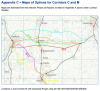
From Bletchley Station the route is on the existing BBM line until south of Bedford where it diverts to the east onto the potential new alignment crossing the MML and ECML, with new split level stations at Bedford Parkway and a relocated Sandy Station. It joins the existing SBR near to Foxton Station and joins the BGK route north of Shelford Station to complete the CC2-2 route at Cambridge Station.
A north-to-east curve near the ECML crossing would be much more useful.
).