Islineclear3_1
Established Member
Yes sorry, I missed that one...Don't thnk so, although there is only a few metres in it.
See post #26

Yes sorry, I missed that one...Don't thnk so, although there is only a few metres in it.
See post #26

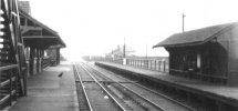
Central station on the Galleons branch always amused me: 'central' to what? It's a pity that the Docklands railway didn't revive the name, and called its nearby station Beckton Park. Here's a picture of Central, scanned from the Middleton book Branch Lines of East London; the only potential passengers appear to be a bloke in the shelter and a cat.There was a station literally called 'Central' in the London Docklands, from 1880 to 1940 when it was blown up during the war. It was two stops after Custom House.

VAR please!All right, I accept the challange!
The red blobs on the OS map, (using Street Map) are at grid references TR1464/5727 (East) and 1455/5840 (West). (To the nearest ten metres). The East station is therefore 14640-14550 = 90 metres further east.
However, the blobs are roughly in the middle of the respective stations, near the entrances. The west end of canterbury East's platforms are at TR1454/5728, and the east end of the West station's platforms at TR1459/5848, which is 50 metres further west.
But grid lines are not perfectly aligned with True North, except along 2 degrees W. Relative to the grid, lines of longitude converge towards the north, so at the longitude of Canterbury, given two points on the same grid easting, the more northerly of the two will be further east in longitude.
Using an online converter between grid and lat/long)
the blobs are
East station 1deg 4' 33" E, 51deg 16' 27" N
West station 1 deg 4' 31" E, 51deg 17' 4" N
A difference in longitude of 2 seconds of arc, which at 51 deg N is about 35 metres
The plaform ends are
(west end of East station) 1 deg 4' 28" E, 51 deg 16' 28" N
(north east end of West station) 1 deg 4' 33"E, 51deg 17' 6" E
Making the two stations overlap by 5 seconds of arc, or about 100 metres
To be fair the cardinal direction is as much a part of the name as it would be if it were written Eastgrinstead, similar to Northampton and Southampton. Similarly in the same area you had West Hoathly station, although East Hoathly village is a little closer, being south of Uckfield.Can I mention East Grinstead which the full name of the town is used (not just Grinstead) it is many miles away from West Grinstead.
Newcastle‘s ‘Central Station’ was so called because it effectively replaced 3 other stations run by different companies, and I believe at the time was a fairly revolutionary idea. Old maps always showed its name as just Central Station. In the 1850s Newcastle‘s built up area was basically east/west along the river, so in that dimension it is fairly central.Newcastle is similar. A relative of mine got confused when he was making a journey from Tynemouth to Hartlepool, and I (perhaps not being as clear as I might have been) said you need to take the metro and then get the train from Newcastle station. “Central Station” didn’t click with him at all, and he actually ended up alighting at Monument and walking, being aware of having done that walk before.
Perhaps it might have been easier if Newcastle was actually “Newcastle Grainger Street”, and the metro station could then be simply “Grainger Street”, akin to the situation in Liverpool. Although well-sited, “Central Station” isn’t really central as such.
I agree Jesmond is odd, although growing up in Heaton I’d have placed the centre much further east, I always thought the two big cemeteries must have divided it from Newcastle. But having checked the late 1800s maps the built up area of Jesmond was all to the east, there was very little development along the railway corridor when the names were being dished out.The Tyne and Wear Metro…
Some of these names are geographically confusing. West Jesmond is north of where I think people would put the centre of Jesmond (near Jesmond station and church), although most of Jesmond is east of both stations. South Gosforth is east of where most people would consider Gosforth to be.
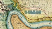
This picture (accessed from https://commons.wikimedia.org/wiki/File:Victoria_Docks_1872.jpg ) shows the layout of the area when only one of the Royal Docks- the Victoria Dock- had been completed. The thin strip of land which currently exists between the Royal Docks and the river thames, which North Woolwich is currently on, would have been less isolated then. The railways precede the later two royal docks in this area. It is interesting to imagine a Victorian equivalent to the Elizabeth Line and DLR tunnels between North Woolwich and Woolwich.And became part of the County of London when that was created in 1888, although the surrounding area remained part of Essex until Greater London became a thing in 1965.
The manor of Woolwich is recorded in the Domesday Book as including territory on the north side of the Thames, although there was little there except the ferry landing.
Similarly North Greenwich, (now the name of the Greenwich peninsula, which was formerly nown as East Greenwich) , was originally the name of the station at the southern tip of the Isle of Dogs on the Millwall Railway (the site of the original Island Gardens station). However, that was never part of Kent.
Perhaps it is surprising that some wag didn't try naming the two stations in East Grinstead "East" and "West" rather "High Level" and "Low Level"!To be fair the cardinal direction is as much a part of the name as it would be if it were written Eastgrinstead, similar to Northampton and Southampton. Similarly in the same area you had West Hoathly station, although East Hoathly village is a little closer, being south of Uckfield.
Wasn't it one station, in the same manner as Lichfield Trent Valley or Tamworth?Perhaps it is surprising that some wag didn't try naming the two stations in East Grinstead "East" and "West" rather "High Level" and "Low Level"!
It was indeed.Wasn't it one station, in the same manner as Lichfield Trent Valley or Tamworth?
And Birmingham has a station called "University" rather than the more specific "Birmingham University".Central station on the Galleons branch always amused me: 'central' to what? It's a pity that the Docklands railway didn't revive the name, and called its nearby station Beckton Park. Here's a picture of Central, scanned from the Middleton book Branch Lines of East London; the only potential passengers appear to be a bloke in the shelter and a cat.
A good question! It seems that Central was midway along the northern boundary wall of the Royal Albert Dock, hence the name. As it was provided solely for access to the dock and had no road access, perhaps the photo captures the height of the rush hour?!Central station on the Galleons branch always amused me: 'central' to what? It's a pity that the Docklands railway didn't revive the name, and called its nearby station Beckton Park. Here's a picture of Central, scanned from the Middleton book Branch Lines of East London; the only potential passengers appear to be a bloke in the shelter and a cat.
There is a "Centrale" on the Croydon Tramlink.A good question! It seems that Central was midway along the northern boundary wall of the Royal Albert Dock, hence the name. As it was provided solely for access to the dock and had no road access, perhaps the photo captures the height of the rush hour?!
But less well known, in the 1860s the LBSC tried to attract more business in Croydon by opening a short branch line to a third station, named Central Croydon.
Perhaps the 6"" map just predated the opening of the station in 1868 before its name had been finalised?Interestingly perhaps, on the two maps (both 6") in the NLS collection which name it, it is called Katherine St Station. On the 1" map it is just "Sta".
What on earth were the LNWR and GER doing in Croydon??? How would they have even got there?Perhaps the 6"" map just predated the opening of the station in 1868 before its name had been finalised?
Central Croydon had another claim to fame. When it reopened in 1886, although it was still part of the LBSC system, it wasn't served by any LBSC trains. All its services were operated by two other companies - the LNWR and the GER. There can't have been many other stations owned by a single company (as opposed to joint stations) which weren't served by the owning company. Anyone know of any others?
It was the location of the Central Offices of the dock company, being halfway along the Albert Dock. Surprisingly the two large 1883 buildings are still there, having somehow survived the WW2 bombing destruction of all around, and are now Listed. One was the Central Administration Building, alias the Dock Manager's House, for all the Royal Docks, and its neighbour is the Central Buffet, main canteen for the docks. The dock company owned the rail line, it was not the GER, so they used their own terms for the station names.Central station on the Galleons branch always amused me: 'central' to what? It's a pity that the Docklands railway didn't revive the name, and called its nearby station Beckton Park. Here's a picture of Central, scanned from the Middleton book Branch Lines of East London; the only potential passengers appear to be a bloke in the shelter and a cat.
Showing what could be done long before TfL and the Overground had been invented! The LNWR came in from Willesden Junction Low Level via Kensington (Addison Road presumably) and Crystal Palace. The GER extended its workings from Liverpool Street to New Cross via the East London Line.What on earth were the LNWR and GER doing in Croydon??? How would they have even got there?
The classic (?) case of this was in Ryde - Pier Head and Esplanade: jointly owned by the LSWR and LBSCR, but only served by the IoWR and IoWCR.There can't have been many other stations owned by a single company (as opposed to joint stations) which weren't served by the owning company. Anyone know of any others?

Central Croydon had another claim to fame.
Thanks; page now updated with Croydon! (typo in date to be corrected this evening)Phil Deaves' Railway Codes web site has - at http://www.railwaycodes.org.uk/stations/notserved.shtm#pre - a list, with appropriate dates. Not necessarily complete - send him updates if you know any he doesn't!
Interestingly perhaps, on the two maps (both 6") in the NLS collection which name it, it is called Katherine St Station. On the 1" map it is just "Sta".
I was going to mention this. Considering their distance apart (roughly 22 mile drive), I have often wondered how this came to be and if there was ever any link between the naming of the settlements.Can I mention East Grinstead which the full name of the town is used (not just Grinstead) it is many miles away from West Grinstead.
Indeed, and I know someone who has modelled this in OO replete with Katharine St name.
I was going to mention this. Considering their distance apart (roughly 22 mile drive), I have often wondered how this came to be and if there was ever any link between the naming of the settlements.
East and West Bridgford are two other places some distance apart that probably got their prefixes when enough people were travelling far enough for it to become confusing.Both place names seem to come from the same Old English root: grenestede meaning green place. It is probable that at some point it became necessary to differentiate between the two places called Grinstead: East and West is the simplest and most obvious.

They are correctly(-ish) named for their orientation (no pun intended) in relation to Hampton though...Northampton and Southampton; neither terribly near Hampton.

Northampton and Southampton; neither terribly near Hampton.