• Our new ticketing site is now live! Using either this or the original site (both powered by TrainSplit) helps support the running of the forum with every ticket purchase! Find out more and ask any questions/give us feedback in this thread!

Radlett Rd Watford

Kevin51

Member
Joined
12 Dec 2019
Messages
61
Location
Herts
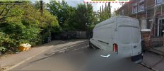
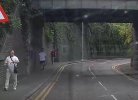
This is Radlett Rd in Watford where it goes under what was the London and Birmingham and now WCML. This is the route I drive into Watford. But what has always bugged me is this a tunnel or a bridge? This would have been built as double track widened at some point to 4 tracks. I assume the brick arch was built before the railway embankment was laid over the top of the arch. Then when widened they extended the arch and widened the embankment. But how is the classified, is it a bridge or a tunnel. It would have been built as a bridge was built with an embankment laid on top and not tunnelled under I assume. So what is?
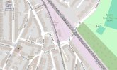
The other two photos show the original Rickmansworth line and now the DC line. Clearly prior to the building of the Rickmansworth line Radlett Rd went straight on where the terraced houses are. Radlett Rd now goes to the right under the bridge sharp right up a ramp the sharp left to join Queen's Rd. My Cassini 1897/1898 map of London doesn't make it clear if Radlett Rd went straight on and there was a level crossing or if the deviation to the right was there when the Rickmansworth line was built. The scale of the map makes it imprecise. The road where the terraced houses are looks to be at too
low a level for there to have been a level crossing. Anybody know?

Radlett Rd 01.jpgRadlett Rd 04.jpgRadlett Rd 05.jpg
 
Sponsor Post - registered members do not see these adverts; click here to register, or click here to log in
R

RailUK Forums

Mcr Warrior

Veteran Member
Joined
8 Jan 2009
Messages
17,150
Have seen the location shown in picture # 1 described both as 'Radlett Road Bridge' AND as the 'Radlett Road Tunnel'. Apparently was known locally as the "Death Trap", on the basis that in the past, there was no separate walkway designated for pedestrians, and two way motor traffic was allowed through! Struggling to find any old OS maps of the area prior to the coming of the railway, several decades earlier. Anyone able to add anything further?
 

Rescars

Established Member
Joined
25 May 2021
Messages
2,516
Location
Surrey
Using the NLS site, the OS 1896 six inch map suggests that there was a level crossing between what is now Queen's Place and the cottages in Ottoman Terrace. This through route is (helpfully!) marked "Lane", though the name "Loates Lane" appears alongside further out of town. It clearly predates the road diversion under the bridge. "Radlett Road" would appear to be a more recent renaming.
 

stuving

Member
Joined
26 Jan 2017
Messages
722
Using the NLS site, the OS 1896 six inch map suggests that there was a level crossing between what is now Queen's Place and the cottages in Ottoman Terrace. This through route is (helpfully!) marked "Lane", though the name "Loates Lane" appears alongside further out of town. It clearly predates the road diversion under the bridge. "Radlett Road" would appear to be a more recent renaming.
I was expecting to find public notices in the Watford Observer about the stopping-up of Loates Lane at the crossing, but so far I haven't. I did however find a reported discussion in Watford UDC (on 31 Jan 1907) about "the LNWR's bill". This does refer to the level crossing in Loates-lane, with concern for those who came down Loates-lane and would find a block - could they be accommodated by a path to the new road so as not to have to go all the way round?

And there is a letter on 10th Sept 1910 about the "ridiculous series of twists and turns accentuated by the presence of towering brick walls on either side" in the new road opened by the LNWR the week before. Three accidents had (he says) already happened in it. "The old road, though a little more steep, did at least bear some resemblance to a straight line." Since this old road is said to have run directly from Loates-lane, this must be Radlett Road, though it's not named.

So that dates the rebuild. The 1896 6" map shows that railway as single line, while in the 1913 one it's double. Presumably this rebuild was done along with the widening of the embankments and bridges. The level crossing must have had a steep hump to cross the railway (hence the wiggle on the map), and perhaps widening the embankment would have made this even worse. It may already have been difficult for some vehicles.
 
Last edited:

Kevin51

Member
Joined
12 Dec 2019
Messages
61
Location
Herts
Using the NLS site, the OS 1896 six inch map suggests that there was a level crossing between what is now Queen's Place and the cottages in Ottoman Terrace. This through route is (helpfully!) marked "Lane", though the name "Loates Lane" appears alongside further out of town. It clearly predates the road diversion under the bridge. "Radlett Road" would appear to be a more recent renaming.
I know where Loates Lane is, that sort of makes sense. Queen's road where the parade of shops is one way. Loates Lane currently runs parallel to and at the
back of Queen's Rd. in the other direction. So driving from Watford Junc you turn right into Loates Lane and go around the back of Queen's Rd to access it at the other end. Queen's Rd is now severed by the inner ring road and from the ring road the High Street is pedestrianised. I remember being able to drive along there.
The little stub of a road on the other side is now Queen's Place but I think there has been a name change there.
I always wondered if originally there was a level crossing but the be honest the level of the old road looks to low to align with the tracks. I wonder if to get the railway bridge built with sufficient height they raised the level of the track. I would expect when the "New Line" was built they took the opportunity to take the level crossing out.
 

Attachments

  • Queen's P;ave.jpg
    Queen's P;ave.jpg
    143.5 KB · Views: 17
  • Radlett Road Layout.jpg
    Radlett Road Layout.jpg
    74.1 KB · Views: 17

Merle Haggard

Established Member
Joined
20 Oct 2019
Messages
3,850
Location
Northampton
Underbridges for roads of that design (an archway with embankment above) seem to be much more common on the L&B than elsewhere. This is also the case on the section North-West of Rugby where the original two track formation remains, so isn';t a future used by later quadrupling.
There's one near Berkswell where the height clearance for road vehicles is very low but there's a considerable height of embankment above it. A few years ago I was delayed on an Avanti service by an ambulance - that was presumably higher than the clearance - becoming stuck in it.
Others I frequently pass under locally are at Ashton and at Blisworth, over the former A43 - the Stamford to Oxford highway.
 

Kevin51

Member
Joined
12 Dec 2019
Messages
61
Location
Herts
I was expecting to find public notices in the Watford Observer about the stopping-up of Loates Lane at the crossing, but so far I haven't. I did however find a reported discussion in Watford UDC (on 31 Jan 1907) about "the LNWR's bill". This does refer to the level crossing in Loates-lane, with concern for those who came down Loates-lane and would find a block - could they be accommodated by a path to the new road so as not to have to go all the way round?

And there is a letter on 10th Sept 1910 about the "ridiculous series of twists and turns accentuated by the presence of towering brick walls on either side" in the new road opened by the LNWR the week before. Three accidents had (he says) already happened in it. "The old road, though a little more steep, did at least bear some resemblance to a straight line." Since this old road is said to have run directly from Loates-lane, this must be Radlett Road, though it's not named.

So that dates the rebuild. The 1896 6" map shows that railway as single line, while in the 1913 one it's double. Presumably this rebuild was done along with the widening of the embankments and bridges. The level crossing mus have had a steep hump to cross the railway (hence the wiggle on the map), and perhaps widening the embankment would have made this even worse. It may already have been difficult for some vehicles.
That is a good point, when the main line was double track the incline would have been more gentle. I wondered if the crossing went when the New Line (Watford High Street to Euston) was built but when the main line was quadrupled makes sense. Since Queen's Rd was made one way and the link to the high street severed and there only be a one way link from the ring road into Queen's Rd this has become a bit of a back water. Also the other road under the railway nearer to Watford Junction used to be a dead end but is now linked to Radlett Road further out of town and most through traffic now takes that road.
From Queen's Place down to Radlett Rd there are some steps see in the photo, just behind the guy furthest from the camera.
"It may already have been difficult for some vehicles." Horse and cart back then I should think

== Doublepost prevention - post automatically merged: ==

This https://www.tripadvisor.com/Attract...e_Aylesbury_Vale_Buckinghamshire_England.html very famous bridge doesn't have any embankment above. This is of course the bridge made famous by the Great Train Robbery

== Doublepost prevention - post automatically merged: ==

Just noticed the Network Rail sign calls it Train Robbers Bridge.
 

Attachments

  • Steps.jpg
    Steps.jpg
    33.8 KB · Views: 11
Last edited:

stuving

Member
Joined
26 Jan 2017
Messages
722
That is a good point, when the main line was double track the incline would have been more gentle. I wondered if the crossing went when the New Line (Watford High Street to Euston) was built but when the main line was quadrupled makes sense.
It should help to see those two 6" OS maps together (from NLS): 1896 on the left and 1913 on the right.
1786978008931.png 1786978045829.png
The earlier map has the LNWR main line already quadruple, and I was talking about the Rickmansworth branch being doubled in 1907-10. This was indeed part of the "New Line" works, most of which were further south.

The way level crossings and underbridges were drawn was very ambiguous, and you have to look for hints as to which it is. Here there is evidence from other sources (newspapers), which helps. But the way the road wiggles as it crosses the railway only makes sense for a (not very) level crossing.
 

Merle Haggard

Established Member
Joined
20 Oct 2019
Messages
3,850
Location
Northampton
/snip
== Doublepost prevention - post automatically merged: ==

This https://www.tripadvisor.com/Attract...e_Aylesbury_Vale_Buckinghamshire_England.html very famous bridge doesn't have any embankment above. This is of course the bridge made famous by the Great Train Robbery

== Doublepost prevention - post automatically merged: ==

Just noticed the Network Rail sign calls it Train Robbers Bridge.
In other photos you can see that there may have once been a shallow embankment above the arch brickwork of the bridge; there's what looks like a later upwards extension in a different style, above the original brickwork of the arch.

Railway Codes website section > Bridges > Euston - Rugby (presumably from Network Rail source) lists the bridge you illustrate as 'Mentmore Bridge off B488' to add to the variety of names.


Buckinghamshire Culture website illustrates 'Bridego Bridge - Train Robbers' with a different bridge - straight girders!
 

Top