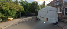
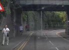
This is Radlett Rd in Watford where it goes under what was the London and Birmingham and now WCML. This is the route I drive into Watford. But what has always bugged me is this a tunnel or a bridge? This would have been built as double track widened at some point to 4 tracks. I assume the brick arch was built before the railway embankment was laid over the top of the arch. Then when widened they extended the arch and widened the embankment. But how is the classified, is it a bridge or a tunnel. It would have been built as a bridge was built with an embankment laid on top and not tunnelled under I assume. So what is?
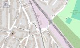
The other two photos show the original Rickmansworth line and now the DC line. Clearly prior to the building of the Rickmansworth line Radlett Rd went straight on where the terraced houses are. Radlett Rd now goes to the right under the bridge sharp right up a ramp the sharp left to join Queen's Rd. My Cassini 1897/1898 map of London doesn't make it clear if Radlett Rd went straight on and there was a level crossing or if the deviation to the right was there when the Rickmansworth line was built. The scale of the map makes it imprecise. The road where the terraced houses are looks to be at too
low a level for there to have been a level crossing. Anybody know?


The other two photos show the original Rickmansworth line and now the DC line. Clearly prior to the building of the Rickmansworth line Radlett Rd went straight on where the terraced houses are. Radlett Rd now goes to the right under the bridge sharp right up a ramp the sharp left to join Queen's Rd. My Cassini 1897/1898 map of London doesn't make it clear if Radlett Rd went straight on and there was a level crossing or if the deviation to the right was there when the Rickmansworth line was built. The scale of the map makes it imprecise. The road where the terraced houses are looks to be at too
low a level for there to have been a level crossing. Anybody know?