
• Our new ticketing site is now live! Using either this or the original site (both powered by TrainSplit) helps support the running of the forum with every ticket purchase! Find out more and ask any questions/give us feedback in this thread!

Mapping your Travels

Status
Not open for further replies.

TheNewNo2

Member
Joined
31 Mar 2015
Messages
1,008
Location
Canary Wharf
Given this is a forum of railway people there will be a fare few people who are trainspotters and/or minded towards self record keeping. So I was just wondering, how do people here map their travels? I personally map everything on Google Earth, and also create various maps of my railway travels.

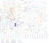
The one attached maps all train journeys I'd taken (up to the end of 2012). Circles are stations, lines are journeys between the stations (done by changes). Thicker lines represent more journeys, larger circles represent more visits to a station.
 

Attachments
  • Sizemap 2012-12-18.jpg
    Sizemap 2012-12-18.jpg
    174.5 KB · Views: 115
Last edited:
Sponsor Post - registered members do not see these adverts; click here to register, or click here to log in
R

RailUK Forums

kareeosman

Member
Joined
1 Jan 2014
Messages
19
The one attached maps all train journeys I'd taken (up to the end of 2012). Circles are stations, lines are journeys between the stations (done by changes). Thicker lines represent more journeys, larger circles represent more visits to a station.

That looks pretty intresting. Any chance of a HQ version?
 

TheNewNo2

Member
Joined
31 Mar 2015
Messages
1,008
Location
Canary Wharf
That looks pretty intresting. Any chance of a HQ version?

I'll see what I can do when I get home - I've been working on these in spare time at work, but I don't have the necessary FTP access here.

--- old post above --- --- new post below ---

http://mattbuck.irongalaxy.com/railways/sizemaps/sizemap 2013-12-20.png - this is the map for the end of 2013.

--- old post above --- --- new post below ---
http://www.southtpe.co.uk/rcv3.gif is pretty popular on here and what I use.

See more on this thread:
http://www.railforums.co.uk/showthread.php?t=17849

In terms of that stuff I just take one of the TOC maps from Project Mapping and scrub off what I've done in black pen. I did try that map once, but I found it hard to use.
 
Last edited:

FQ

Established Member
Associate Staff
Quizmaster
Joined
4 Oct 2013
Messages
6,645
Location
-
Bakers Rail Atlas.
 

ooo

Member
Joined
8 Jun 2015
Messages
707
Location
S
Given this is a forum of railway people there will be a fare few people who are trainspotters and/or minded towards self record keeping. So I was just wondering, how do people here map their travels? I personally map everything on Google Earth, and also create various maps of my railway travels.

The one attached maps all train journeys I'd taken (up to the end of 2012). Circles are stations, lines are journeys between the stations (done by changes). Thicker lines represent more journeys, larger circles represent more visits to a station.
What program did you use to do this?
 

theblackwatch

Established Member
Joined
15 Feb 2006
Messages
10,889
Another one for Baker here. And for my European travels, I use the European Rail Atlas, which I bought as a PDF publication and printed out. Unfortunately, even though it's over 100 A4 pages, I wish it was a bigger scale, as not all stations are shown.
 
Status
Not open for further replies.

Top