

TheNewNo2
Member
Given this is a forum of railway people there will be a fare few people who are trainspotters and/or minded towards self record keeping. So I was just wondering, how do people here map their travels? I personally map everything on Google Earth, and also create various maps of my railway travels.
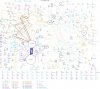
The one attached maps all train journeys I'd taken (up to the end of 2012). Circles are stations, lines are journeys between the stations (done by changes). Thicker lines represent more journeys, larger circles represent more visits to a station.
The one attached maps all train journeys I'd taken (up to the end of 2012). Circles are stations, lines are journeys between the stations (done by changes). Thicker lines represent more journeys, larger circles represent more visits to a station.
Attachments
Last edited:


