• Our new ticketing site is now live! Using either this or the original site (both powered by TrainSplit) helps support the running of the forum with every ticket purchase! Find out more and ask any questions/give us feedback in this thread!

HS2 Progress near Kenilworth

swt_passenger

Veteran Member
Joined
7 Apr 2010
Messages
34,252
This is not the worst example. Some sort of tunnel would be needed here, but I agree that it could probably be shorter.

In regards of "pointlessness" nothing beats Chipping Warder Green Tunnel...
That’s to avoid having a relatively deep cutting, at about 45-50m deep, which at modern standards would require about a 200m wide void in the existing hill. I think it’s a reasonable decision compared to leaving it fully open.
 
Last edited:
Sponsor Post - registered members do not see these adverts; click here to register, or click here to log in
R

RailUK Forums

Snow1964

Established Member
Joined
7 Oct 2019
Messages
11,065
Location
West Wiltshire
New drone footage of HS2 section near Stoneleigh.

Very little seems to have happened on this section, apart from fencing off a very wide strip of land


Snow1964

Established Member
Joined
7 Oct 2019
Messages
11,065
Location
West Wiltshire
Another new drone flyover, from Burton Green towards the crossing of Coventry-Birmingham line

Seems long way from being finished as a trackbed


== Doublepost prevention - post automatically merged: ==

New drone video of HS2 construction near Kenilworth


== Doublepost prevention - post automatically merged: ==

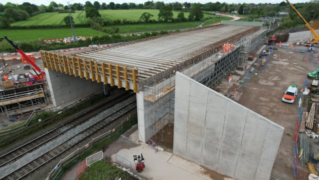
HS2 have installed all the beams for the diagonal rail over rail bridge at Burton Green / Balsall Common

A 91-metre bridge designed to carry HS2 over the existing West Coast Main Line near Kenilworth is taking shape, following the successful installation of 83 giant concrete beams.

Installed using a 500-tonne crawler crane, the horizontal beams collectively form the deck of the bridge structure that will eventually be used as part of the high-speed rail line.

Each beam measures 19 metres in length, with 81 beams weighing 18.1 tonnes and two beams weighing 33 tonnes – a total of 1,532.1 tonnes. The Carol Green rail bridge structure will, on completion, span over 20 metres, 7.5 metres in height and 91 metres in width.


Also a video

 
Last edited:

Geezertronic

Established Member
Joined
14 Apr 2009
Messages
4,124
Location
Birmingham
Does anyone have a link to the proposed re-routing of the A452 between the Hampton-in-Arden and Balsall Common islands now they have completed the A452 Kenilworth Road overbridge?
 

Geezertronic

Established Member
Joined
14 Apr 2009
Messages
4,124
Location
Birmingham
Thanks.

That actually confuses me as the HS2 website says that the new overbridge is to re-route the A452 over HS2 but that PDF suggests that the overbridge will be used instead to re-route the road that leads to Mercote Hall Lane (and include a new roundabout at Lincoln Farm Truck Stop), and that the A452 will get an overbridge in the current A452 alignment?
 

swt_passenger

Veteran Member
Joined
7 Apr 2010
Messages
34,252
Thanks.

That actually confuses me as the HS2 website says that the new overbridge is to re-route the A452 over HS2 but that PDF suggests that the overbridge will be used instead to re-route the road that leads to Mercote Hall Lane (and include a new roundabout at Lincoln Farm Truck Stop), and that the A452 will get an overbridge in the current A452 alignment?
I wouldn’t like to say really, I’ve compared it with the current OS map but I’m not getting much joy yet working out what and why. Was not looking at a big enough screen, I see @stuving and @snowball have solved the puzzle now…
 
Last edited:

stuving

Member
Joined
26 Jan 2017
Messages
722
Having peered at the HS2 map, and Googles Earth and Maps, side by side, I can see that the A452 will be shifted sideways to the east and south so it goes over the concrete box/bridge now being built. The HS2 map has a red line that shows where the current road is, and if you look at the divergence of Marsh Lane and the A452 they now part, then close up (with Coleman Roofing in the narrow gap) then part again. In HS2's vision they diverge steadily.
 

snowball

Established Member
Joined
4 Mar 2013
Messages
8,144
Location
Leeds
In the map linked in #70, the original line of the A452 is in the left edge of the pale green area to the left of the new line, indicating it will be planted over once the new alignment is open. If the equipment you're using to view it is slow enough, then when you increase the scale, you can see the old line momentarily before the new is painted over it.
 
Last edited:

bnc2018

Member
Joined
14 May 2021
Messages
51
Location
Banbury, Oxfordshire
It's actually quite hard to get HS2 plans - there are plans as part of the bill environmental statement, but then a lot of them are superseded by the additional provisions, and the original maps aren't updated, you just have to piece things together from the original maps and the snippets of maps in the AP
 

Geezertronic

Established Member
Joined
14 Apr 2009
Messages
4,124
Location
Birmingham
Be interesting to see how they re-route the A452 over that overbridge and what gap will be in-between the two sets of dual carriageway, and it will also be interesting to see when they start the new roundabout too
 

swt_passenger

Veteran Member
Joined
7 Apr 2010
Messages
34,252
It's actually quite hard to get HS2 plans - there are plans as part of the bill environmental statement, but then a lot of them are superseded by the additional provisions, and the original maps aren't updated, you just have to piece things together from the original maps and the snippets of maps in the AP
That’s very pertinent. We saw quite a few changes in the vicinity of the EWR/HS2 crossing, where for example you just have to know when looking at the main map series that the southern depot access spur is no longer being built…
 

stuving

Member
Joined
26 Jan 2017
Messages
722
Be interesting to see how they re-route the A452 over that overbridge and what gap will be in-between the two sets of dual carriageway, and it will also be interesting to see when they start the new roundabout too
To make direct comparison easier, here's the HS2 plan rotated to north-up, scaled (by eye) to match, and side by side with the latest Google Earth picture. The box is definitely in the same place as on the plan, but significantly shorter. So it will indeed be interesting to see how the road fits onto it.
1724931015917.png
 

Geezertronic

Established Member
Joined
14 Apr 2009
Messages
4,124
Location
Birmingham
To make direct comparison easier, here's the HS2 plan rotated to north-up, scaled (by eye) to match, and side by side with the latest Google Earth picture. The box is definitely in the same place as on the plan, but significantly shorter. So it will indeed be interesting to see how the road fits onto it.
View attachment 164510
I drove past it the other day - must admit that it looks bigger/wider in person than on the photos, I just think that the overhead compared to the plan has it aligned more to the right so it could cause an unnecessary kink in the road alignment. I still think it looks more aligned to carrying the road that leads to Mercote Hall Lane though. I guess only time will tell...
 

swt_passenger

Veteran Member
Joined
7 Apr 2010
Messages
34,252
To make direct comparison easier, here's the HS2 plan rotated to north-up, scaled (by eye) to match, and side by side with the latest Google Earth picture. The box is definitely in the same place as on the plan, but significantly shorter. So it will indeed be interesting to see how the road fits onto it.
The road bridge under discussion here has been reported complete by HS2, a recent video from ‘wandering northerner’ shows the current situation. Still looks as though the road will need a significant ‘S bend’:
 

Snow1964

Established Member
Joined
7 Oct 2019
Messages
11,065
Location
West Wiltshire
New drone video near Southam with realigned A425 and the cut and cover section beyond the bored tunnels


== Doublepost prevention - post automatically merged: ==

New drone video of HS2 route near A46


(videos are credited to their authors)
 
Last edited:

bib

Member
Joined
15 Nov 2021
Messages
247
Location
East Midlands
They've started excavation on the east side of the road over Burton Green tunnel, which will almost join it up with the portal that was built ages ago.
 

swt_passenger

Veteran Member
Joined
7 Apr 2010
Messages
34,252
HS2 video on Burton Green tunnel and adjacent retained cuttings,
showing work taking place to dig out material within the structures:

 
Last edited:

david1212

Established Member
Joined
9 Apr 2020
Messages
1,754
Location
Midlands
To prepare for pushing in the box structure that is being built off-line for HS2 to pass under the A46 the A46 is scheduled to be closed from
8pm Friday 7 February to 6am Monday 10 February and 8pm Friday 14 February to 6am Monday 17 February.

At dates to be set there will then be a final longer closure later in the spring to push the new box into place.

Reference
https://assets.hs2.org.uk/wp-conten...2-works-A46-weekend-closure-February-2025.pdf
 

RyanOPlasty

Member
Joined
9 Feb 2020
Messages
163
Location
Nuneaton
To prepare for pushing in the box structure that is being built off-line for HS2 to pass under the A46 the A46 is scheduled to be closed from
8pm Friday 7 February to 6am Monday 10 February and 8pm Friday 14 February to 6am Monday 17 February.

At dates to be set there will then be a final longer closure later in the spring to push the new box into place.

Reference
https://assets.hs2.org.uk/wp-conten...2-works-A46-weekend-closure-February-2025.pdf
Considering the costs incurred in constructing HS2, I find it surprising that the A46 needs to be closed for such a long time. It seems that elsewhere similar bridges can be pushed into place over a weekend. I remember the Bridge being installed under the Coventry to Rugby line for Allard Way, and that was completed in a weekend with time to spare over 40 years ago.
 

The Planner

Veteran Member
Joined
15 Apr 2008
Messages
19,655
Considering the costs incurred in constructing HS2, I find it surprising that the A46 needs to be closed for such a long time. It seems that elsewhere similar bridges can be pushed into place over a weekend. I remember the Bridge being installed under the Coventry to Rugby line for Allard Way, and that was completed in a weekend with time to spare over 40 years ago.
Isnt it 6 lanes along there? Thats not the same as pushing under a two track railway.
 

swt_passenger

Veteran Member
Joined
7 Apr 2010
Messages
34,252
Isnt it 6 lanes along there? Thats not the same as pushing under a two track railway.
I suspect the reinstatement time quoted for the Allard Way bridge didn’t include building the new road. As you suggest it seems obvious that when a bridge is pushed through an existing operational 6 lane dual carriageway the time to reinstate the road surfaces to their normal condition will take much longer than reinstating two ballasted tracks.
 

Top