
-
Our new ticketing site is now live! Using either this or the original site (both powered by TrainSplit) helps support the running of the forum with every ticket purchase! Find out more and ask any questions/give us feedback in this thread!
You are using an out of date browser. It may not display this or other websites correctly.
You should upgrade or use an alternative browser.
You should upgrade or use an alternative browser.
GB rail map (as a graph)
- Thread starter sfiliste
- Start date
- Status
- Not open for further replies.
Sponsor Post - registered members do not see these adverts; click here to register, or click here to log in
R
RailUK Forums
zwk500
Veteran Member
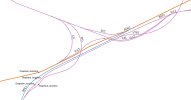
Lines ZZY (which ORM has a TRL9) and ZZZ (which ORM has as ISL2) do not connect to SPC2, but only to HS1 (ELR is TRL1 in this area). There is also a Spur from CRF1 to TLR1 towards stratford.So, I try to simplify. Here is the schematic (without the High Speed Line). Two lines ZZZ and ZZY are added. Do I forget any spur?
If you are excluding HS1 I would Exclude ZZY/ZZZ as well, as they do not allow trains to travel from the MML. It is functionally as separate from HS1 as Euston or King's Cross.
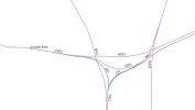
This is very nearly there, you're just missing a connection from RDG1 to the Junction of BSP2/CKL (this connection is FLL2). Depending on what you want this map to show you could merged RDG1 and BML once they're beyond the junction with SCC. There's connections but arguably they can't really be treated as a single 8-track line until Waterloo itself (and even then you can't go fully side-to-side at any point).So, I correct Clapham Junction in the schematic below (RDG1 in orange, BML1 in blue)
Out of interest what are your data sources?
Sorry, but I dont understand. Is it possible for a train toLines ZZY (which ORM has a TRL9) and ZZZ (which ORM has as ISL2) do not connect to SPC2, but only to HS1 (ELR is TRL1 in this area). There is also a Spur from CRF1 to TLR1 towards stratford.
If you are excluding HS1 I would Exclude ZZY/ZZZ as well, as they do not allow trains to travel from the MML. It is functionally as separate from HS1 as Euston or King's Cross.
- leave St Pancras and then go to CRF1 line per ZZY (Eastbound)
- leave St Pancras and then go to CRF1 line per ZZZ (Westbound)
Or does it mean that I have to represent two lines leaving St Pancras to split the station between
- St Pancras (platform 1 to 4) going only to SPC1
- St Pancras international part (platform 5 to 10) going to TRL1
New schematic below.
This is very nearly there, you're just missing a connection from RDG1 to the Junction of BSP2/CKL (this connection is FLL2).
I try to add it. New schematic below.Depending on what you want this map to show you could merged RDG1 and BML once they're beyond the junction with SCC. There's connections but arguably they can't really be treated as a single 8-track line until Waterloo itself (and even then you can't go fully side-to-side at any point).
Out of interest what are your data sources?
GitHub - openraildata/network-rail-gis: Geospatial information released by Network Rail
Geospatial information released by Network Rail. Contribute to openraildata/network-rail-gis development by creating an account on GitHub.
 github.com
Attachments

And if you're going to include either of them, then Aberdeen - Inverness, which has far more services, should probably be in there as well.In Scotland, more trains run to Oban than to Fort William.
zwk500
Veteran Member
Your map is very nearly correct - all existing links shown are correct, but you are missing 1 extra link from TRL2 direction to CRF1 (it would join at the same junction as ZZZ/CRF1.Sorry, but I dont understand. Is it possible for a train to
- leave St Pancras and then go to CRF1 line per ZZY (Eastbound)
- leave St Pancras and then go to CRF1 line per ZZZ (Westbound)
If you leave St Pancras 1-4 you can only go to SPC1.
If you leave St Pancras 5-13 you can go to BOK, ECM, or TRL2.
Coming from BOK you can go to St Pancras, TRL2 or ECM,
Coming from TRL2 you can go to St Pancras or BOK.
I think ZZZ is ISL2 and ZZY is ISL1 going by ORM and the HS1 Sectional Appendix.
The station should be split. I don't think it needs to be split down as far as 5-10 and 11-13.Or does it mean that I have to represent two lines leaving St Pancras to split the station between
- St Pancras (platform 1 to 4) going only to SPC1
- St Pancras international part (platform 5 to 10) going to TRL1
Clapham Junction now looks right.

Annetts key
Established Member
Keep in mind that the vast majority of passenger trains go via Weston-super-Mare and "the loop line" (WSM). Only non-stop / limited stop passenger trains and freight use the main line (locally called "the avoider"). Obviously the route via WSM is slightly longer in both distance and time.

Similarly for Westbury.Keep in mind that the vast majority of passenger trains go via Weston-super-Mare and "the loop line" (WSM). Only non-stop / limited stop passenger trains and freight use the main line (locally called "the avoider"). Obviously the route via WSM is slightly longer in both distance and time.
zwk500
Veteran Member
You've omitted many lines that while not 'main lines' in the traditional sense are busier or more important than some lines you have included.Hello everyone,
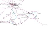
The new map is now this one.
I just need to check London, then I can provide the data set to the forum, after final extraction of the arcs and nodes.
Brighton-Seaford and South Croydon-East Grinstead being left off while Marshlink is included is a confusing choice. Kent is also dramtically oversimplified yet the line via Melksham is included.
Last edited:
Yes I'm not convinced by the omission of Darlington to Saltburn (which sees reasonable amount of freight flows along with passenger services) but the inclusion of York to Scarborough. This is the services at Malton (midway between Scarborough and York) and the services at Thornaby today. Which is more important? Or omitting the line between Sunderland and Newcastle which sees again freight as well as Northern services and 5tph TW Metro services each way (as far as Pelaw junction when they branch off onto their own infrastructure).You've omitted many lines that while not 'main lines' in the traditional sense are busier or more important than some lines you have omitted.
Surely either of those warrants inclusion above Scarborough (not wishing to bad mouth the good people of Scarborough mind you!).
PLY2AYS
Member
Agree with both of those; similarly with the Chiltern Mainline.You've omitted many lines that while not 'main lines' in the traditional sense are busier or more important than some lines you have omitted.
Brighton-Seaford and South Croydon-East Grinstead being left off while Marshlink is included is a confusing choice. Kent is also dramtically oversimplified yet the line via Melksham is included.
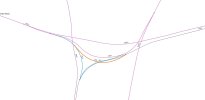
Thank you for all your help. New version of St Pancras with ZZZ -> ISL2 ; ZZY -> ISL1 ; new link from TRL2 to CRF1 in orange which is ZZXYour map is very nearly correct - all existing links shown are correct, but you are missing 1 extra link from TRL2 direction to CRF1 (it would join at the same junction as ZZZ/CRF1.
If you leave St Pancras 1-4 you can only go to SPC1.
If you leave St Pancras 5-13 you can go to BOK, ECM, or TRL2.
Coming from BOK you can go to St Pancras, TRL2 or ECM,
Coming from TRL2 you can go to St Pancras or BOK.
I think ZZZ is ISL2 and ZZY is ISL1 going by ORM and the HS1 Sectional Appendix.
The station should be split. I don't think it needs to be split down as far as 5-10 and 11-13.
Clapham Junction now looks right.
== Doublepost prevention - post automatically merged: ==
OK. I add itKeep in mind that the vast majority of passenger trains go via Weston-super-Mare and "the loop line" (WSM). Only non-stop / limited stop passenger trains and freight use the main line (locally called "the avoider"). Obviously the route via WSM is slightly longer in both distance and time.
== Doublepost prevention - post automatically merged: ==
OK. But it was already drawn per Westbury.Similarly for Westbury.
== Doublepost prevention - post automatically merged: ==
I add some lines in Kent. I know how difficult is to simplify a map!Brighton-Seaford and South Croydon-East Grinstead being left off while Marshlink is included is a confusing choice. Kent is also dramtically oversimplified yet the line via Melksham is included.
Attachments
Last edited:
Regarding which lines you should include:
Then the approach you need to take is:
- First make a list of what "A" and "B" can be. Presumably these are stations above some level of importance, e.g. city population, catchment area, "places I've heard of", etc.
- Determine which lines you need to include in order to get correct answers for all A and B pairs.
In general, the second step is hard. You can make some easy simplifications: a dead-end line that doesn't serve any of your supported stations can clearly be omitted. (Example: Edinburgh-Tweedbank, if neither Tweedbank nor Galashiels is in your list.) Beyond that, you would really need to (1) enter all the lines, and (2) use an algorithm to determine which are not needed, and remove them.
Are you perhaps a computer science student doing this as a project? If so, are you aware of "contraction hierarchies"?
* You really do need to include London Farringdon, with links to Paddington, St Pancras, Liverpool Street and London Bridge *
The main objective is to be able to compute rail distances from A to B.
Then the approach you need to take is:
- First make a list of what "A" and "B" can be. Presumably these are stations above some level of importance, e.g. city population, catchment area, "places I've heard of", etc.
- Determine which lines you need to include in order to get correct answers for all A and B pairs.
In general, the second step is hard. You can make some easy simplifications: a dead-end line that doesn't serve any of your supported stations can clearly be omitted. (Example: Edinburgh-Tweedbank, if neither Tweedbank nor Galashiels is in your list.) Beyond that, you would really need to (1) enter all the lines, and (2) use an algorithm to determine which are not needed, and remove them.
Are you perhaps a computer science student doing this as a project? If so, are you aware of "contraction hierarchies"?
* You really do need to include London Farringdon, with links to Paddington, St Pancras, Liverpool Street and London Bridge *

QueensCurve
Established Member
- Joined
- 22 Dec 2014
- Messages
- 2,196
back in the 1980s, it only had two passenger services: The daytime Clansman service between Euston and Inverness via Birmingham and the Sleeper between Euston and Fort William (joining/leaving the rout at Gartsherrie South Junction). The latter was rerouted to reverse at Stirling about 1985 after an intruder stabbed a woman to death during the reversal at Cowlairs. Both services did the diesel/electric loco swap at Mossend Yard.[GB – North]
Is the line from Motherwell to Lambert (and Stirling) an important line? It looks like it is the only way to go without turn back from West Coast line to Perth and Inverness ?
I think they have more services and now and the route is fully electrified.
Various local services have been introduced since that between them cover the whole route - but for the time being no single passenger service uses it end to end.I think they have more services and now and the route is fully electrified.
Cheshire Scot
Established Member
Also Sleeper from Euston to Inverness (Fort William was a portion off the Inverness train detached/attached at Mossend)back in the 1980s, it only had two passenger services: The daytime Clansman service between Euston and Inverness via Birmingham and the Sleeper between Euston and Fort William (joining/leaving the rout at Gartsherrie South Junction). The latter was rerouted to reverse at Stirling about 1985 after an intruder stabbed a woman to death during the reversal at Cowlairs. Both services did the diesel/electric loco swap at Mossend Yard.
- Status
- Not open for further replies.