Our new ticketing site is now live! Using either this or the original site (both powered by TrainSplit) helps support the running of the forum with every ticket purchase! Find out more and ask any questions/give us feedback in this thread!
Of the funded plans: The original phase 1a has now been completed. Phase 1b would have been from Haymarket to Granton. Phase 1b was cancelled in 2009 due to rising costs.
Authorised but not funded, the full line 1 loop would have been completed with a stop at Lower Granton (between Granton and Leith) as phase 2, with an extension to Newbridge to complete line 2 (St Andrews Square to Airport/Newbridge) as phase 3.
The original line 3 (Haymarket to Musselburgh) didn't get approval.
I was privileged to be on the first tram through to Newhaven today with a friend.
Scott Arthur, the Edinburgh City Council transport convener was present. He stated that the Council's present intention is now to work towards further extensions - the next proposal being Granton out to Dalkeith.
I think that the completion of the loop back from Granton to Haymarket, part of the original scheme, is now unlikely ; the old railway route is now a key cycle and pedestrian artery. As suggested above a route towards the hospital and beyond is now more likely.
I think that the completion of the loop back from Granton to Haymarket, part of the original scheme, is now unlikely ; the old railway route is now a key cycle and pedestrian artery. As suggested above a route towards the hospital and beyond is now more likely.
They route up the bridges is hopelessly unviable, while they have a well-developed plan for sharing the Granton route with our cycling betters, so I'd say the opposite is more likely
I don't think it'd be good to set the precedent that active travel should block the reopening of disused railway alignments.
While the Roseburn path might be a good cycle lane, there's actually an argument against relying on these and similar off-street routes as active travel corridors. It's all well and good on a summery Sunday afternoon taking the dog for a walk while allowing small kids to pootle along on their bikes alongside. However, for active travel to really work, people have to be willing to do it at all times of day, and in all conditions. The Roseburn path might be busy enough for it not to be too much of a problem but there are plenty of people who rather wouldn't cycle or walk alone, in the dark, and pretty far from any place of safety. The same isn't true on well-lit and busy roads with shops and people living directly on them. To that end, adding the tram might actually help, as there'd be more infrastructure like the relative safety of a CCTV-equipped tram stop and more people around.
My understanding is that the width under the bridges is a major problem now. Unless the bridges are rebuilt at great expense, it'll be difficult to fit a proper cycle and walking path in alongside a two-track tramway. I think a reasonable compromise then might be short sections of gauntlet track to maximise the path width. I don't imagine the Granton line will go up beyond 8tph so it shouldn't act as a major capacity bottleneck.
Isn't there also a problem with sending the tram from Granton via Crewe Road South, Orchard Brae and Queensferry Road in trying to fit the tram infrastructure on the Dean Bridge?
Although from Google Street view it looks wide enough.
However the disruption caused during the construction phase would be considerable.
Would a simpler solution not be simply to take the path up to cross the road on the level, leaving the bridge for the trams? Something done for example on Camphill in Paisley on Route 75, the former Paisley Canal/Elderslie section.
Would a simpler solution not be simply to take the path up to cross the road on the level, leaving the bridge for the trams? Something done for example on Camphill in Paisley on Route 75, the former Paisley Canal/Elderslie section.
It's quite common when converting current or former railways to tramway to fill cuttings and remove embankments to be level with the surrounding ground and remove any bridges, taking advantage of the ability of trams to climb steeper gradients than trains and to cross roads on the level. The footprint that was previously the slopes either side means there is more width to provide cycleways, soundproofing and landscaping.
If the Granton route were to connect with the present tram line, how long would it take to lay and insert the points as the work could or would disrupt the whole system?
== Doublepost prevention - post automatically merged: ==
When trams run Part Route to Murrayfield for concerts, Rugby etc, I imagine they go back towards Haymarket 'wrong line' to Haymarket siding then cross onto the correct track there? Is that right as it seems to be the only option.
If the Granton route were to connect with the present tram line, how long would it take to lay and insert the points as the work could or would ldisrupt the whole system?
== Doublepost prevention - post automatically merged: ==
When trams run Part Route to Murrayfield for concerts, Rugby etc, I imagine they go back towards Haymarket 'wrong line' to Haymarket siding then cross onto the correct track there? Is that right as it seems to be the only option.
It looks to me as if some passive provision for this has been built into the system.
In the video below, showing the route from the City to the Airport, if you pause the video at 13 minutes 15 seconds, I can see a junction off the line between Murrayfield and Haymarket
Similarly, in this video showing the route from the Airport to the City, if pause the video at 19 minutes 55 seconds, I can see the same junction.
The location of the junction seems to be at the location, near Russell Road, where the former Caledonian Railway line from Leith North and Barnton would have crossed over the main line and joined the line into Princes Street station, now occupied by the West Approach Road.
In Manchester they did a similar thing when the Eccles line was built, by putting in pointwork for a potential future line to the Trafford Centre where the line to Eccles turns right after leaving Cornbrook.
If the purpose of this junction is not passive provision for a future line to Granton, I would be interested what its purpose is.
It is exactly for that purpose. However it remains to be seen if it will ever get used. Certainly running over the old railway should disrupt far less people, while road running could arguably disrupt more than it ever has done. If the council are ever wanting to be serious about getting people on their side then that’s a good start. Not to mention the likely higher speed limits, probably close to the trams’ limit.
From what I can see the biggest obstacle for the roads if you opted to run via the old railway is probably West Granton Road. That would need a proper tunnel installed as I think that’s too shallow at the minute. Installing a bridge over Ferry Road should at most require temporary traffic lights as the foundations on one side remain, while one is set up for the current pedestrian bridge and would need to be expanded upon. A full weekend closure could then be implemented to install the new bridge.
I’m particularly interested to see if they opt for something similar to what Croydon has with its single line working. Of course rather than the railway being the other side a footpath? I did wonder if there are parts where they would need to do this. The plus side is it’s cheaper as well.
For me building the Granton to Dalkeith line in one go is going to cause mass disruption yet again. Splitting these into two is a much more sensible idea. And yes I’m acutely aware that the council are not exactly known for picking the sensible option, but one can hope!
It is exactly for that purpose. However it remains to be seen if it will ever get used. Certainly running over the old railway should disrupt far less people, while road running could arguably disrupt more than it ever has done. If the council are ever wanting to be serious about getting people on their side then that’s a good start. Not to mention the likely higher speed limits, probably close to the trams’ limit.
From what I can see the biggest obstacle for the roads if you opted to run via the old railway is probably West Granton Road. That would need a proper tunnel installed as I think that’s too shallow at the minute. Installing a bridge over Ferry Road should at most require temporary traffic lights as the foundations on one side remain, while one is set up for the current pedestrian bridge and would need to be expanded upon. A full weekend closure could then be implemented to install the new bridge.
I’m particularly interested to see if they opt for something similar to what Croydon has with its single line working. Of course rather than the railway being the other side a footpath? I did wonder if there are parts where they would need to do this. The plus side is it’s cheaper as well.
For me building the Granton to Dalkeith line in one go is going to cause mass disruption yet again. Splitting these into two is a much more sensible idea. And yes I’m acutely aware that the council are not exactly known for picking the sensible option, but one can hope!
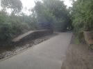
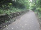
The two photos below are from when I walked along the old railway line from Murrayfield to Leith whilst on holiday in Edinburgh in 2020.
The first photo is at the site of the former Murrayfield Station and the second photo is a little further North.
I suppose if they demolished the former station platforms they might have room for a double track tramway, plus a footpath.
If they opted for a single track tramway with passing loops plus a footpath, then you would have to consider how frequent a service could be provided without adversely affecting service reliability.
If they opted for a single track tramway with passing loops plus a footpath, then you would have to consider how frequent a service could be provided without adversely affecting service reliability.
If it was implemented where needed it should still be able to offer an every 10 minutes along the line, which in my view is more than good enough. Granton to Airport trams I imagine would not be very common and likely would probably be just depot moves, thus the west junction would be rarely used and the majority of trams run to/from the city.
If it was implemented where needed it should still be able to offer an every 10 minutes along the line, which in my view is more than good enough. Granton to Airport trams I imagine would not be very common and likely would probably be just depot moves, thus the west junction would be rarely used and the majority of trams run to/from the city.
The Beckenham Junction line of the London tram system is single track with passing loops, mainly because it has to share space with an existing National Rail line.
The off peak service frequency is every 10 minutes, so a similar frequency should be achievable in Edinburgh.
This is due to the over complicated way they’ve set the destination displays up to be linked to the onboard TCMS (tram control and management system) where the driver has to input a ‘route number’, of which there are several (for example, Airport to St Andrew Square is 1, Gyle Centre to St Andrew Square is 2, Airport to Newhaven is 3 etc) instead of just having a separate control unit just for the screens where the driver can quite easily reach St Andrew Square and change it to show ‘Not in Service’. I presume this is a system really meant for more complex networks with multiple routes as it would then allow for automatic switching of points depending on what ‘route’ the tram was on.
It is exactly for that purpose. However it remains to be seen if it will ever get used. Certainly running over the old railway should disrupt far less people, while road running could arguably disrupt more than it ever has done. If the council are ever wanting to be serious about getting people on their side then that’s a good start. Not to mention the likely higher speed limits, probably close to the trams’ limit.
From what I can see the biggest obstacle for the roads if you opted to run via the old railway is probably West Granton Road. That would need a proper tunnel installed as I think that’s too shallow at the minute. Installing a bridge over Ferry Road should at most require temporary traffic lights as the foundations on one side remain, while one is set up for the current pedestrian bridge and would need to be expanded upon. A full weekend closure could then be implemented to install the new bridge.
I’m particularly interested to see if they opt for something similar to what Croydon has with its single line working. Of course rather than the railway being the other side a footpath? I did wonder if there are parts where they would need to do this. The plus side is it’s cheaper as well.
For me building the Granton to Dalkeith line in one go is going to cause mass disruption yet again. Splitting these into two is a much more sensible idea. And yes I’m acutely aware that the council are not exactly known for picking the sensible option, but one can hope!
The original TIE-run tram project had pretty much complete designs for all of the Granton line, and most of the documents are still up on the council's planning portal.
When the route crosses West Granton Road it was going to be a pretty plain level crossing. The West Granton Access road is built on the old railway alignment, and the plan was to put the twin-track tram route west of and parallel to the road.
Here's the other end at the Crewe Toll tramstop, showing the transition from the parallel to the dedicated Roseburn Path corridor.
The original TIE-run tram project had pretty much complete designs for all of the Granton line, and most of the documents are still up on the council's planning portal.
I’ve lived in the area since birth and I’ve never known that it was an entirely new bridge from scratch that was proposed rather than re-using the old foundations. That’s very interesting. The space right enough is there, but it seems like a lot more work than necessary? Of course any plans now could be revised, but it seems silly to re-do them.
The level crossing on West Granton Road at first sounds like a no-go, but could work given the fact a similar idea at South Gyle Broadway already exists. Mind you that is a 4 way junction that never gets any quieter as the years go on. Not to mention the constant on-off development that goes on.
The Beckenham Junction line of the London tram system is single track with passing loops, mainly because it has to share space with an existing National Rail line.
The off peak service frequency is every 10 minutes, so a similar frequency should be achievable in Edinburgh.
Yes the Beckenham Junction line has no alternative. Admittedly in Edinburgh there is, but it’s not without its problems. I guess in Edinburgh’s case you’re looking at a majority double track set up with single track bi-directional working only where necessary.
I’ve lived in the area since birth and I’ve never known that it was an entirely new bridge from scratch that was proposed rather than re-using the old foundations. That’s very interesting. The space right enough is there, but it seems like a lot more work than necessary? Of course any plans now could be revised, but it seems silly to re-do them.
The level crossing on West Granton Road at first sounds like a no-go, but could work given the fact a similar idea at South Gyle Broadway already exists. Mind you that is a 4 way junction that never gets any quieter as the years go on. Not to mention the constant on-off development that goes on.
Yes the Beckenham Junction line has no alternative. Admittedly in Edinburgh there is, but it’s not without its problems. I guess in Edinburgh’s case you’re looking at a majority double track set up with single track bi-directional working only where necessary.
The level crossing isn't going to be a problem. Indeed, some of the justification for reopening the design of the Granton branch is that we now understand even better that we should prioritise the tram over road traffic. Trying really hard to keep it away from road traffic isn't a good idea when we should be reducing the amount of road traffic anyway. Signal priorities etc mean that we can always fit in the time for the tram to run quickly, as it's just a question of how much lower we put other road traffic in the priority list.
The physical reality of the tram is still a factor against using the road and a factor for using disused railway lines. Disused railway lines don't normally include corners that would be too awkward for the tram to get around. Getting from Telford Road onto West Granton Access at the Crewe Toll roundabout would be a challenge unless they can demolish the fire station.
I’ve lived in the area since birth and I’ve never known that it was an entirely new bridge from scratch that was proposed rather than re-using the old foundations. That’s very interesting. The space right enough is there, but it seems like a lot more work than necessary? Of course any plans now could be revised, but it seems silly to re-do them.
The level crossing on West Granton Road at first sounds like a no-go, but could work given the fact a similar idea at South Gyle Broadway already exists. Mind you that is a 4 way junction that never gets any quieter as the years go on. Not to mention the constant on-off development that goes on.
Yes the Beckenham Junction line has no alternative. Admittedly in Edinburgh there is, but it’s not without its problems. I guess in Edinburgh’s case you’re looking at a majority double track set up with single track bi-directional working only where necessary.
Line T2 of the tramway in Valenciennes, France is mostly single track, with passing loops at tram stops, but it can manage a 12 minute frequency.
I would have thought that most of the old railway line in Edinburgh would have enough room for double track over the majority of the line, but whether there is also room for a cycle path is another matter.
I'm walking on the Roseburn Path right now and the answer is generally yes, so long as it's alright to cut back the tree lines on either side and install cutting walls when necessary. There is plenty of space for the cycle path and one single tram line under and over each bridge, but not two. Since most of the route is fine I think short sections of gauntlet track would still allow the original 8tph frequency. It's not really any worse than having to share the road with traffic on the on-street sections.
I think the other part of it is that the resulting corridor would look much less lush and green, and that wouldn't go down well with the great and good of the west end suburbs. It would make the route look a lot more like what it does through the more plebby areas to the north, like Pilton.
I'm walking on the Roseburn Path right now and the answer is generally yes, so long as it's alright to cut back the tree lines on either side and install cutting walls when necessary. There is plenty of space for the cycle path and one single tram line under and over each bridge, but not two. Since most of the route is fine I think short sections of gauntlet track would still allow the original 8tph frequency. It's not really any worse than having to share the road with traffic on the on-street sections.
I think the other part of it is that the resulting corridor would look much less lush and green, and that wouldn't go down well with the great and good of the west end suburbs. It would make the route look a lot more like what it does through the more plebby areas to the north, like Pilton.
A similar thing happened in the West Midlands after the lines out of Birmingham Snow Hill were closed in 1972.
Part of the trackbed of the old railway was converted into a footpath in the West Bromwich area.
When the West Midlands Metro was constructed in the 1990s the footpath was retained, but it now is shoehorned in at the side of the tram tracks, crossing the tracks in several places, rather than occupying the whole trackbed.
Reusing the Roseburn Path as a tramway would presumably cost a lot less than laying tram tracks along existing roads, and I would have thought less disruptive.
Whilst current users of the path may not be pleased, you have to decide whether it is ultimately for the greater good that it gets repurposed as a tramway.
It is exactly for that purpose. However it remains to be seen if it will ever get used. Certainly running over the old railway should disrupt far less people, while road running could arguably disrupt more than it ever has done. If the council are ever wanting to be serious about getting people on their side then that’s a good start. Not to mention the likely higher speed limits, probably close to the trams’ limit.
From what I can see the biggest obstacle for the roads if you opted to run via the old railway is probably West Granton Road. That would need a proper tunnel installed as I think that’s too shallow at the minute. Installing a bridge over Ferry Road should at most require temporary traffic lights as the foundations on one side remain, while one is set up for the current pedestrian bridge and would need to be expanded upon. A full weekend closure could then be implemented to install the new bridge.
I’m particularly interested to see if they opt for something similar to what Croydon has with its single line working. Of course rather than the railway being the other side a footpath? I did wonder if there are parts where they would need to do this. The plus side is it’s cheaper as well.
For me building the Granton to Dalkeith line in one go is going to cause mass disruption yet again. Splitting these into two is a much more sensible idea. And yes I’m acutely aware that the council are not exactly known for picking the sensible option, but one can hope!
Even in the original TIE plans, the Airport-to-Granton chord was dashed and marked as a "future alignment". The reason for it to be included as a future alignment is that the structural base of the junction is part of the bridge over Russell Road. Not designing it in now would mean a complete bridge replacement would be needed to add in a relatively small chord, which would likely make it never worth building.
I think the main benefit of this chord only happens once the Granton line is linked up to the Newhaven one and the loop is completed. With the loop complete and the chord in place, it would be possible to run trams Airport-Murrayfield-Granton-Newhaven-Leith Walk-St Andrew Square for events like Hogmanay when Princes Street is shut. Without this chord, you could run a West End-Granton-Newhaven-Leith Walk-St Andrew Square service, but you become limited by tram reversing capacity at Haymarket Yards and Shandwick Place.
Otherwise, it's just handy to have these little chords around even if they aren't used much. Eventually someone will come up with a use-case. I don't imagine it would cost much to add it in if you're already doing the work to add the main Granton branch connection in.
Even in the original TIE plans, the Airport-to-Granton chord was dashed and marked as a "future alignment". The reason for it to be included as a future alignment is that the structural base of the junction is part of the bridge over Russell Road. Not designing it in now would mean a complete bridge replacement would be needed to add in a relatively small chord, which would likely make it never worth building.
I think the main benefit of this chord only happens once the Granton line is linked up to the Newhaven one and the loop is completed. With the loop complete and the chord in place, it would be possible to run trams Airport-Murrayfield-Granton-Newhaven-Leith Walk-St Andrew Square for events like Hogmanay when Princes Street is shut. Without this chord, you could run a West End-Granton-Newhaven-Leith Walk-St Andrew Square service, but you become limited by tram reversing capacity at Haymarket Yards and Shandwick Place.
Otherwise, it's just handy to have these little chords around even if they aren't used much. Eventually someone will come up with a use-case. I don't imagine it would cost much to add it in if you're already doing the work to add the main Granton branch connection in.
I imagine another benefit would be to allow trams to run empty from the depot to Granton and vice versa without reversing at Haymarket Yards. The chord could also be used for special services during events at Murrayfield.
Overall definitely a wise move to leave provision for it.
Here's an example of the bridge problem. The footpath would be reduced down to a minimum of 1975mm between the stone bridge abutment and the fence separating the tramway. That 1975mm is unacceptable now because it would make it a major bottleneck and indeed a safety hazard for cyclists passing each other and pedestrians.
With gauntlet track, it would be possible to at least double the width of the path. It wouldn't need to be any narrower than any other sections of the path along the route.
For those who haven’t read it, the Edinburgh Strategic Sustainable Transport Study Phase 2 report (catchy) is an interesting analysis of the route options for the future North-South line (including those that have been discounted).
In particular, there’s detail on what major structures work would be required to deliver the off-road Granton tram route without comprising the now important active travel route:
AFAIK, the Granton-Newhaven stretch is deceptively complex and expensive due to major seawall works that would be required. I wouldn’t expect to see it anytime soon, although perhaps it could be a candidate for some sort of single track running similar to what’s mentioned above.
For those who haven’t read it, the Edinburgh Strategic Sustainable Transport Study Phase 2 report (catchy) is an interesting analysis of the route options for the future North-South line (including those that have been discounted).
In particular, there’s detail on what major structures work would be required to deliver the off-road Granton tram route without comprising the now important active travel route: View attachment 136934
AFAIK, the Granton-Newhaven stretch is deceptively complex and expensive due to major seawall works that would be required. I wouldn’t expect to see it anytime soon, although perhaps it could be a candidate for some sort of single track running similar to what’s mentioned above.
I hate reading those documents. They so casually discuss turning our excellent bus network into a messy patchwork of feeder routes into trams, completely failing to analyse the connection times, or how utterly unpleasant it is to wait in the wind and rain at a "transit centre". It's like the authors have never regularly commuted by public transport at all.