causton
Established Member
Interesting to see something other than the ex-Metronet/Tube Lines (I forget) wagons parked in the sidings opposite Hornsey depot!


,fraid not!Does the wifi homepage on the virgin train have any kind of map already?
Can I use this map on my FGW trip from Paddington to Swansea?

This is a tricky one to fix - but I know the cause.
If you are on a train, then the onboard device reports your position in m/s
If you are not, then the data is returned in knots - and the conversions are obviously different to mph
I think I have put in a programmatic fix - though it will break if the onboard system ever switches back to knots!
Try it now
Ben
I'm using it now on the 1450 ABD-DON, the location is accurate but the speed is about half the correct speed, it says we are doing 46mph and we are probably doing 90+


No because it doesn't go to EDBDoes this look about right for a height profile of the ECML?


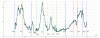
So having worked out where the data feed was but not having the skill required to do something as snazzy as dbrb2's map, I have been testing some data logging ideas for an entirely unrelated project. Hence a sudden graph...
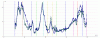
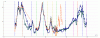
Does this look about right for a height profile of the ECML? Obviously the GPS doesn't cope too well with being in tunnels or buildings, but otherwise OK?
Very good! I'm intrigued.Does this look about right for a height profile of the ECML?
Reflecting on this, I think it's worth noting that:
The thought never entered my head!If there are any problems, they are not my fault!
. In particular I notice that during the time the train it spent in Newcastle (slightly over an hour), Newcastle rose more than 30 <units?> relative to the sea...
I didn't know that, thanks.Altitude measurements from GPS are often far more variable than position. . . . .
. . . . One might see that in areas of dodgy GPS reception, fewer satellites are in view, and there is greater variability in recorded height.
I think that is something we must just accept, particularly in terms of altitude.GPS really doesn't seem to like buildings.
 .
.