Thanks everyone, I needed a double check and you've all confirmed what I thought it should be.
I was taken by surprise that the L&Y would buy such a large plot or plots or land this specific area. It's centred around the very old manor house called Martholme, which by this time was occupied by tenant farmers. To the left of the manor we have the large Martholme embankment, and to the bottom right of this, we have Martholme colliery which until 1895 was not connected to the branch line.
Question please, Could we justify 740,520 square feet being used to widen this embankment? The L&Y had to build a shorter connecting embankment to meet the Martholme embankment, so that's part of the land used. The Martholme embankment back in 1895 looks to have been widened to accommodate the colliery sidings.
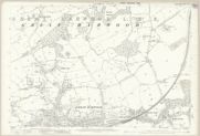
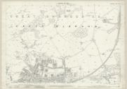
Please compare these two map sheets from the NLS (Manor house not shown on these):
1890.

maps.nls.uk
1909.
maps.nls.uk
Do you think the main embankment has been widened for the colliery sidings?
And do you think this accounts for the land purchase?
Thanks,
Andy.