• Our new ticketing site is now live! Using either this or the original site (both powered by TrainSplit) helps support the running of the forum with every ticket purchase! Find out more and ask any questions/give us feedback in this thread!

37 Acres, Calculation Help Please

Status
Not open for further replies.

Andy873

Established Member
Joined
23 Mar 2017
Messages
1,408
I'm trying to work out how much land (in square feet etc) the L&Y bought from a local landowner back in 1885.

They bought 37 acres for £7,919.

Could someone please tell me what 37 acres is in:

A. Square feet.
B. Square Miles.

Thanks,
Andy.
 
Sponsor Post - registered members do not see these adverts; click here to register, or click here to log in
R

RailUK Forums

hexagon789

Veteran Member
Joined
2 Sep 2016
Messages
18,287
Location
Glasgow
I'm trying to work out how much land (in square feet etc) the L&Y bought from a local landowner back in 1885.

They bought 37 acres for £7,919.

Could someone please tell me what 37 acres is in:

A. Square feet.
B. Square Miles.

Thanks,
Andy.
One square mile is 640 acres.

So 1 acre is 43,560 square feet.
 

Mcr Warrior

Veteran Member
Joined
8 Jan 2009
Messages
17,161
37 acres = 0.0578125 square miles. = Approximately one-seventeenth of a square mile. Or 37 acres = 740,520 square feet, if you prefer, depending, of course, on just how accurately the acreage had been measured in the first place. So, £214 per acre.
 

Magdalia

Established Member
Joined
1 Jan 2022
Messages
7,315
Location
The Fens
I'm trying to work out how much land (in square feet etc) the L&Y bought from a local landowner back in 1885.

They bought 37 acres for £7,919.

Could someone please tell me what 37 acres is in:

A. Square feet.
B. Square Miles.

Thanks,
Andy.
The acre is the standard imperial measure for area of land, so it helps to think about the question in imperial measures. The acre originates as a strip of land 10 chains long and 1 chain wide. A chain is a standard measure of length on the railway, and is also the length of a cricket pitch. 10 chains make a furlong, a distance still commonly used in horse racing, and 8 furlongs make a mile.

If you think of a square mile as having 64 squares like a chessboard, with 8 row and 8 files, then each square of that chessboard is 10 acres.

One square mile is 640 acres.
Hence a square mile is 640 acres.

40 acres in a square would be 4 squares in the square mile chessboard and would have sides a quarter of a mile long.

37 acres is a bit smaller than 4 chessboard squares, and if square, would have sides a shade under a quarter of a mile long.

On the other hand, if the 37 acres were "end to end" in a long strip only 1 chain wide, then the strip would be nearly 5 miles long!
 
Last edited:

Taunton

Veteran Member
Joined
1 Aug 2013
Messages
12,223
The acre is the standard imperial measure for area of land, so it helps to think about the question in imperial measures. The acre originates as a strip of land 10 chains long and 1 chain wide. A chain is a standard measure of length on the railway, and is also the length of a cricket pitch. 10 chains make a furlong, a distance still commonly used in horse racing, and 8 furlongs make a mile.

If you think of a square mile as having 64 squares like a chessboard, with 8 row and 8 files, then each square of that chessboard is 10 acres.


Hence a square mile is 640 acres.

40 acres in a square would be 4 squares in the square mile chessboard and would have sides a quarter of a mile long.

37 acres is a bit smaller than 4 chessboard squares, and if square, would have sides a shade under a quarter of a mile long.

On the other hand, if the 37 acres were "end to end" in a long strip only 1 chain wide, then the strip would be nearly 5 miles long!
If you find chains challenging in old railway documentation, they are 22 yards, or 66 feet. A standard Mk 1 carriage (and much else since) was 64 ft 6 in, so 10 chains on an old drawing is 10 carriage lengths.

An acre is 209 feet squared, so about 3.5 carriages each side. Or 10 carriages long and just one carriage wide.
 

Rescars

Established Member
Joined
25 May 2021
Messages
2,517
Location
Surrey
Chains continue to be used on the railway as a means of determining the locations of structures such as bridges. These structures are frequently marked with the distance in miles and chains measured from a zero point (typically the end of the line).
 

91130nut

Member
Joined
12 Aug 2019
Messages
60
One square mile is 640 acres.

So 1 acre is 43,560 square feet.
A useful aide-memoire for this calculation is "four ate for nothing", as there are 4840 square yards in an acre ! Given that I still remember it from schooldays in the 1960s, it does work.
 

Andy873

Established Member
Joined
23 Mar 2017
Messages
1,408
Thanks everyone, I needed a double check and you've all confirmed what I thought it should be.

I was taken by surprise that the L&Y would buy such a large plot or plots or land in this specific area. It's centred around the very old manor house called Martholme, which by this time was occupied by tenant farmers. To the left of the manor we have the large Martholme embankment, and to the bottom left of this, we have Martholme colliery which until 1895 was not connected to the branch line.

Question please, Could we justify 740,520 square feet being used to widen this embankment? The L&Y had to build a shorter connecting embankment to meet the Martholme embankment, so that's part of the land used. The Martholme embankment back in 1895 looks to have been widened to accommodate the colliery sidings.

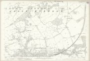
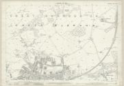
Please compare these two map sheets from the NLS (Manor house not shown on these):

1890.


1909.


Do you think the main embankment has been widened for the colliery sidings?
And do you think this accounts for the land purchase?

Thanks,
Andy.

 

simonw

Established Member
Joined
7 Dec 2009
Messages
1,398
Thanks everyone, I needed a double check and you've all confirmed what I thought it should be.

I was taken by surprise that the L&Y would buy such a large plot or plots or land this specific area. It's centred around the very old manor house called Martholme, which by this time was occupied by tenant farmers. To the left of the manor we have the large Martholme embankment, and to the bottom right of this, we have Martholme colliery which until 1895 was not connected to the branch line.

Question please, Could we justify 740,520 square feet being used to widen this embankment? The L&Y had to build a shorter connecting embankment to meet the Martholme embankment, so that's part of the land used. The Martholme embankment back in 1895 looks to have been widened to accommodate the colliery sidings.

Please compare these two map sheets from the NLS (Manor house not shown on these):

1890.


1909.


Do you think the main embankment has been widened for the colliery sidings?
And do you think this accounts for the land purchase?

Thanks,
Andy.
It may be that the landowner wasn't prepared to sell a smaller acreage.

If you follow the saga of the Lynton and Barnstaple rebuild they often have to buy a much larger plot than they require as the landowner sets a minimum.
 

stuving

Member
Joined
26 Jan 2017
Messages
722
Thanks everyone, I needed a double check and you've all confirmed what I thought it should be.

I was taken by surprise that the L&Y would buy such a large plot or plots or land in this specific area. It's centred around the very old manor house called Martholme, which by this time was occupied by tenant farmers. To the left of the manor we have the large Martholme embankment, and to the bottom left of this, we have Martholme colliery which until 1895 was not connected to the branch line.

Question please, Could we justify 740,520 square feet being used to widen this embankment? The L&Y had to build a shorter connecting embankment to meet the Martholme embankment, so that's part of the land used. The Martholme embankment back in 1895 looks to have been widened to accommodate the colliery sidings.

Please compare these two map sheets from the NLS (Manor house not shown on these):

1890.


1909.


Do you think the main embankment has been widened for the colliery sidings?
And do you think this accounts for the land purchase?

Thanks,
Andy.
Have you tried identifying the matching plots on both maps and tallying the areas that are changed in some way - split, joined, or repurposed? The plots do in general have clearly marked boundaries, and the areas were carefully worked out and written in (though railway land is on long odd-shaped plots that can be hard to follow between map sheets).

Ideally only the nearby plots are altered, and outside that they are renumbered but have the same areas. This case is a bit more complex than that, but a quick look suggests that the railway line into the colliery was added to its area and only 0.2 acres became L&Y railway land.
 

Snow1964

Established Member
Joined
7 Oct 2019
Messages
11,029
Location
West Wiltshire
It may be that the landowner wasn't prepared to sell a smaller acreage.
Quite common where a landowner would have been left with a narrow strip that was difficult or useless to farm. So would sell whole plot or field rather than be stuck with small bit.

Another common one was having to buy the land to build approaches to overbridges, these might have been tapered plots so a sloped embankment with a road (probably cart track originally) could pass over the bridge. By 1880s & 1890s most mainline companies (but not impoverished branch lines) built proper bridges and gently sloped approaches, and avoided new level crossings.
 

simonw

Established Member
Joined
7 Dec 2009
Messages
1,398
Quite common where a landowner would have been left with a narrow strip that was difficult or useless to farm. So would sell whole plot or field rather than be stuck with small bit.
That's the point I was making.
 

Magdalia

Established Member
Joined
1 Jan 2022
Messages
7,315
Location
The Fens
Here in the Fens I get to see a lot of construction projects, including the new Cambridge South station.

Construction projects need a lot of temporary land for staff accommodation, plus storage of plant and equipment, stocks of raw materials, and waste for disposal.

Methods of working might have been very different, but land would still have been needed temporarily for all of these.

Have you researched whether any of the land was subsequently sold once the project had been completed?
 

Andy873

Established Member
Joined
23 Mar 2017
Messages
1,408
It may be that the landowner wasn't prepared to sell a smaller acreage.

If you follow the saga of the Lynton and Barnstaple rebuild they often have to buy a much larger plot than they require as the landowner sets a minimum.
An extremely good point made here, and one I hadn't considered!

The land to the left of the embankment is hilly, so probably only suitable for sheep farming, to the right is the valley floor which then, like now is prone to flooding from the river.

Have you tried identifying the matching plots on both maps and tallying the areas that are changed in some way - split, joined, or repurposed? The plots do in general have clearly marked boundaries, and the areas were carefully worked out and written in (though railway land is on long odd-shaped plots that can be hard to follow between map sheets).
Yes, I have had a look at the plots but can't really see any changes.

To help people visualise an acre, its about half a football pitch.
For me, that's a great way to visualise the size of an acre.

Have you researched whether any of the land was subsequently sold once the project had been completed?
You're on the same wavelength as me here, yes I have been looking around to see if there was any subsequent re-sale but can't find any. The best suggestion I could put forward is perhaps the L&Y (once the widening of the embankment was completed) leased the remaining land to one of the local farmers, if you can't re-sell the remaining land, you might as well earn a little from it.

One thing is very apparent to me is that railway companies very commonly planed many years ahead.

Thanks everyone.
 
Status
Not open for further replies.

Top