Sun Chariot
Established Member
I'm conscious the EWR route construction topic has finished. This post is actually a question to the wise, as I haven't found an answer via Internet searches.
A couple of days ago, I scouted out a road overbridge just north of Whaddon village, about 2 miles west of Bletchley. I'd missed that location when photographing October's week of IET/168 runs.
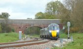
At Whaddon, the two running lines diverge, passing through different arches. The lines have a low mound of earth piled between them - and what I'd initially thought was remnants of a wide island platform.
Except.... LNWR never built a station or halt at Whaddon. I've found a photo of the location in pre-EWR days - both running lines pass under just one bridge arch and no line separation.
So, my question: why have the running lines been laid with a separation for EWR?
Thanks in advance.
A couple of days ago, I scouted out a road overbridge just north of Whaddon village, about 2 miles west of Bletchley. I'd missed that location when photographing October's week of IET/168 runs.
At Whaddon, the two running lines diverge, passing through different arches. The lines have a low mound of earth piled between them - and what I'd initially thought was remnants of a wide island platform.
Except.... LNWR never built a station or halt at Whaddon. I've found a photo of the location in pre-EWR days - both running lines pass under just one bridge arch and no line separation.
So, my question: why have the running lines been laid with a separation for EWR?
Thanks in advance.