• Our new ticketing site is now live! Using either this or the original site (both powered by TrainSplit) helps support the running of the forum with every ticket purchase! Find out more and ask any questions/give us feedback in this thread!

East-West Rail (EWR): Oxford-Bletchley construction progress

Status
Not open for further replies.

EIKN

Member
Joined
19 Sep 2017
Messages
113
Hi thank you for the photo , may I ask as I'm not up on the technical side of railways , my interest is the reopening projects like these , and with this line how it really ought to be used by other rail operators , for longer distance trips , and providing choice for rail users , eg GWR from the west , via Oxford and this line , to for example , when it opens it will be going to meet in Bedford by incorporating the Marston vale section that remained open , and is said to just need udating.

Anyway apologies for being off topic there .
Re this bridge , why did they not build the railway at the original track level , because from your photos, the EWR / Varsity line , seems to climb quite steeply , to cross what looks to be two bridges ? One is clearly the road , but the other looked narrow , ( or that may have been my eyesight ), is this where HS2 crosses ?.
Also is this where that plan , seems to show a lot of sidings built and some part of HS2 , running parallel with EWR/Varsity line?.

did I read correctly that it's related to a maintenance depot or stabling for one of the lines ?.
Also is this also where the Aylesbury link would run or will be running , I'm not sure if that is getting built along with this section.

Another question ( my apologies for so many , I have a health issue that affects memory so if I've already asked or am asking a few questions, it's because I forget or am just genuinely interested)
It's related to the height of the line above the original level , isn't it a bit steep ?, or have they raised the level of the whole route?.
 
Sponsor Post - registered members do not see these adverts; click here to register, or click here to log in
R

RailUK Forums

snowball

Established Member
Joined
4 Mar 2013
Messages
8,144
Location
Leeds
Re this bridge , why did they not build the railway at the original track level , because from your photos, the EWR / Varsity line , seems to climb quite steeply , to cross what looks to be two bridges ?
East-West Rail is being built above the original track level at this point because it is rising to go over HS2.
 

swt_passenger

Veteran Member
Joined
7 Apr 2010
Messages
34,308
Hi thank you for the photo , may I ask as I'm not up on the technical side of railways , my interest is the reopening projects like these , and with this line how it really ought to be used by other rail operators , for longer distance trips , and providing choice for rail users , eg GWR from the west , via Oxford and this line , to for example , when it opens it will be going to meet in Bedford by incorporating the Marston vale section that remained open , and is said to just need udating.

Anyway apologies for being off topic there .
Re this bridge , why did they not build the railway at the original track level , because from your photos, the EWR / Varsity line , seems to climb quite steeply , to cross what looks to be two bridges ? One is clearly the road , but the other looked narrow , ( or that may have been my eyesight ), is this where HS2 crosses ?.
Also is this where that plan , seems to show a lot of sidings built and some part of HS2 , running parallel with EWR/Varsity line?.

did I read correctly that it's related to a maintenance depot or stabling for one of the lines ?.
Also is this also where the Aylesbury link would run or will be running , I'm not sure if that is getting built along with this section.

Another question ( my apologies for so many , I have a health issue that affects memory so if I've already asked or am asking a few questions, it's because I forget or am just genuinely interested)
It's related to the height of the line above the original level , isn't it a bit steep ?, or have they raised the level of the whole route?.
The EWR gradients are fairly inconsequential. In a lot of the photos that are uploaded in this forum the distance you’re seeing along the track is around 4 km or more. The steepness is effectively a photographic illusion. Someone referred to it a few months ago as a ski-jump, but it really isn’t anything like that.

I think the EWR bridge over HS2 is roughly the same width between parapets as the road bridge, again it’s just the perspective of the image that makes the foreground bridge look wider.
 
Last edited:

EIKN

Member
Joined
19 Sep 2017
Messages
113
Thank you both for your replies, it makes sense now, I did think the same ( the ski jump ) it does appear like a hump back bridge , but there must be something of a gradient.
I had read they will use the class 196's that will be pleased airline style from I think West midlands rail ? I gather as two and four car sets . I did wonder seeing how it will continue over the only part left open , that being between Bletchley and Bedford , I wondered if they'd ever use a service from Birmingham for example using Chilterns , 68/Mark 3 sets , and go then down the midland mainline Into London .
I only mention this, because this line is probably far more useful than HS2 as it avoids the need to go via London should you not want to have that hassle .
Hence my previously mentioned GWR as others have mentioned, eg a 5 car 800 on the line .
It's a heck of a lot of well engineered line just to be operated by small DMU's .
And when it does reach Cambridge it will effectively cross every north south mainline , and link the Anglia Region, this is also ideal for freight heading to the ports in the east .
I have seen plans for where it runs beside I believe the midland mainline for some distance, showing all the properties that have to be bulldozed for it .
There was one village where they had objected, yet some of them complaining , had lived there before the original line closed . And unlike a road it's not constant noise .
I do think for best use of the route , that passing loops for freight or slower services would boost the routes flexibility.
Years ago there was that plan for an M25 style railway right around London , but this restored varsity line , seems to negate much of that need , by as I say crossing or joining so many mainline north south routes .is there another thread about potential operators and how the line should or could be used ?.
I'd hope that the government eventually honour the pledge to make it fully electric.
 

12LDA28C

Established Member
Joined
14 Oct 2022
Messages
5,058
Also is this where that plan , seems to show a lot of sidings built and some part of HS2 , running parallel with EWR/Varsity line?.

did I read correctly that it's related to a maintenance depot or stabling for one of the lines ?.
Also is this also where the Aylesbury link would run or will be running , I'm not sure if that is getting built along with this section.

This was already answered on the previous page in post #1251 and #1252.
 

EIKN

Member
Joined
19 Sep 2017
Messages
113
This was already answered on the previous page in post #1251 and #1252.
My apologies, I missed it totally as I only have a link in my email and right now my health is at rock bottom, and am exhausted so my memory is not the best .
Anyway I did just have a quick peek at the photos and am confused, because one seems to clearly show track laid underneath the old brick bridge , all ballasted and everything you'd see on a finished line .
Yet another image and it's higher ?
Am I missing something
 

swt_passenger

Veteran Member
Joined
7 Apr 2010
Messages
34,308
Anyway I did just have a quick peek at the photos and am confused, because one seems to clearly show track laid underneath the old brick bridge , all ballasted and everything you'd see on a finished line .
Yet another image and it's higher ?
Am I missing something
If you let us know the exact post number I expect we’ll be able check out exactly what you’re looking at.

But as an example, if you were looking at the first image in post #1232, then that’s looking away from the HS2/EWR intersection area, towards Bicester. It’s showing the boundary fence between the HS2 zone, and the track you can see is laid all the way from there to Bicester.

Then the fourth image in post #1232 is looking east from the same bridge that you’re viewing in the first image, with the HS2 site in the far distance.
 
Last edited:

fishwomp

Established Member
Joined
5 Jan 2020
Messages
1,353
Location
milton keynes
Yes, I’m sure that’s the correct explanation. That’s the left/right road and brick arch bridge on the screen grab in my post yesterday. I believe where they refer to the tie in works to join the “new temporary road” they mean the stretch further to the north of the EWR crossing. Where the new road passes under the replacement Charndon Lodge bridge it will be in its permanent position.

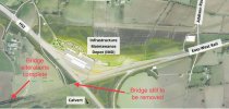
I’ve annotated part of an earlier photo provided by @fishwomp, (I hope that’s ok), to show what I think is the change from permanent to temporary alignment:
Of course! Thanks for doing that. I'm really glad they're about to wrap up with that bridge, it's time to get EWR finished!
 

swt_passenger

Veteran Member
Joined
7 Apr 2010
Messages
34,308
Of course! Thanks for doing that. I'm really glad they're about to wrap up with that bridge, it's time to get EWR finished!
I took a detour down that road about 4 weeks ago and it still looked like there was loads to do south of the new road bridge, but I suppose it’s fairly straightforward work with a whole months closure.

I was wondering if the new longer Addison Road bridge over the depot access area has reopened to public traffic, I think this week was supposed to be the date. Can’t get along there for a few weeks now.

PS

I have just found a presentation to Calvert Green parish council from last week, it suggests Addison Road might be reopened in mid-October, and that the handover of the remaining embankment section to EWR is planned for the end of November.

Here’s the link to the presentation: https://calvertgreenparish.co.uk/media/CALM/280923/CALM 280923 DRAFT presentation.pdf
 
Last edited:

Mark J

Member
Joined
12 May 2018
Messages
658
Is is yet known if the connection to Aylesbury will be happening.

If not, a huge opportunity missed - yet again.

Does HS2 obliterate the former route through Quainton Road Station.

== Doublepost prevention - post automatically merged: ==

To think this route was nothing more than the Oxford to Bicester single track branch line, from 1987 until a few years ago.
 
Last edited:

The Planner

Veteran Member
Joined
15 Apr 2008
Messages
19,728
Is is yet known if the connection to Aylesbury will be happening.

If not, a huge opportunity missed - yet again.

Does HS2 obliterate the former route through Quainton Road Station.

== Doublepost prevention - post automatically merged: ==

To think this route was nothing more than the Oxford to Bicester single track branch line, from 1987 until a few years ago.
Like HS2, its paused. HS2 have to rebuild the Aylesbury Vale Parkway to Claydon bit. Quainton is left alone.
 

swt_passenger

Veteran Member
Joined
7 Apr 2010
Messages
34,308
Does HS2 obliterate the former route through Quainton Road Station.
The HS2 route passes somewhat west of Quainton Road station, and the two routes then converge about half a mile to the northwest of the station. Theres’s alterations to the local road layout but no effect at all on the railway centre.
 

12LDA28C

Established Member
Joined
14 Oct 2022
Messages
5,058
Is is yet known if the connection to Aylesbury will be happening.

If not, a huge opportunity missed - yet again.

Does HS2 obliterate the former route through Quainton Road Station.

== Doublepost prevention - post automatically merged: ==

To think this route was nothing more than the Oxford to Bicester single track branch line, from 1987 until a few years ago.

This has been mentioned several times in this thread. I already stated a few posts back that the existing route (currently lifted) through Quainton Road will be reinstated - it has to be for household waste traffic serving the (relocated) Calvert waste disposal site.

And the route from Bicester to Bletchley was still open for freight until well into the 1990s.
 

Mark24

Member
Joined
18 Sep 2018
Messages
77
This has been mentioned several times in this thread. I already stated a few posts back that the existing route (currently lifted) through Quainton Road will be reinstated - it has to be for household waste traffic serving the (relocated) Calvert waste disposal site.

And the route from Bicester to Bletchley was still open for freight until well into the 1990s.
I think Claydon to Bletchley section was mothballed in 1993.
But the line was singled before then. Not sure of the date it happened.
 

Sun Chariot

Established Member
Joined
16 Mar 2009
Messages
6,734
Location
2 miles and 50 years away from the Longmoor Milita
I think Claydon to Bletchley section was mothballed in 1993.
But the line was singled before then. Not sure of the date it happened.
Might have been end-1993, or a little later.

December 1992, I rode an NSE "Christmas shopper" special, from Aylesbury to Milton Keynes and back. 4-car 115/108 set, past Quainton and Calvert, o Claydon Junction, then to Bletchley flyover and onto WCML.

Throughout summer 1993, I photographed the Calvert-Avon "bin-liner", at locations such as Claydon Junction / Bicester where the Bletchley line passes under the Chiltern Line. My old 35mm prints include an ARC 59/1 at the latter location, with the Whatley-Wolverton stone.
 

EIKN

Member
Joined
19 Sep 2017
Messages
113
If you let us know the exact post number I expect we’ll be able check out exactly what you’re looking at.

But as an example, if you were looking at the first image in post #1232, then that’s looking away from the HS2/EWR intersection area, towards Bicester. It’s showing the boundary fence between the HS2 zone, and the track you can see is laid all the way from there to Bicester.

Then the fourth image in post #1232 is looking east from the same bridge that you’re viewing in the first image, with the HS2 site in the far distance.
Hiya thank you for the reply , it is post 1232 , and the first image showing img ( 1509) what it appears to.show is double track ballasted but under the old brick bridge , I had thought that a previous photo showed track in the same state ' paused ' just before that bridge , ( looking towards the old brick bridge ) and no sign of track under the old bridge .
Hence my confusion.
Also my fybro ' brain fog ' isn't helping figuring out the viewpoints or optical illusions , it might be easier if there was a plan view of where the new track stops either side, I had assumed the new track was indeed higher than the old bridge , as somone said on an earlier post , the images from the end of the new track stopping as I described, were on that post described as a ' ski jump ' I had indeed asked about why they would build such a steep incline in order to go over the old bridge and join the new embankments either side which are higher than that old bridge , from.the replies I'd had .( hope that makes sense ), so when I saw the photo that clearly seems to show track going under that old bridge and probably an illusion but seems to have a notable ' dip ' , Is why I'm struggling to get my head around, what they are doing.
As I thought the new embankments where level with the road height of the old bridge .
Again hence why I asked why track us under a bridge which will be removed and the new embankments much higher would fully that location ?.
Sorry for the slightly muddled questions, with my brain fog I sometimes find it hard to work it out .
 

swt_passenger

Veteran Member
Joined
7 Apr 2010
Messages
34,308
Hiya thank you for the reply , it is post 1232 , and the first image showing img ( 1509) what it appears to.show is double track ballasted but under the old brick bridge , I had thought that a previous photo showed track in the same state ' paused ' just before that bridge , ( looking towards the old brick bridge ) and no sign of track under the old bridge .
Hence my confusion.
Here’s an annotated version of the plan from post #1251. The bridge at far left is the one in post #1232.
 

Attachments

  • IMG_1358.jpeg
    IMG_1358.jpeg
    1.1 MB · Views: 127

EIKN

Member
Joined
19 Sep 2017
Messages
113
Here’s an annotated version of the plan from post #1251. The bridge at far left is the one in post #1232.
Thank you , so does it have track underneath?
On a different note , I do wish they'd reuse the old bricks to clad new bridges with, especially stone bridges , as they surely are more pleasant to look at and soften the impact of the railway on the surrounding countryside.
I gather the bridge at leven will be clad in the old stone as I described.
For helping it to blend in with what is a scenic area .
 

swt_passenger

Veteran Member
Joined
7 Apr 2010
Messages
34,308
Thank you , so does it have track underneath?
Yes, as seen in the photo.
On a different note , I do wish they'd reuse the old bricks to clad new bridges with, especially stone bridges , as they surely are more pleasant to look at and soften the impact of the railway on the surrounding countryside.
I gather the bridge at leven will be clad in the old stone as I described.
For helping it to blend in with what is a scenic area .
It‘s probably far too expensive.
 

zwk500

Veteran Member
Joined
20 Jan 2020
Messages
18,639
Location
Northampton
It‘s probably far too expensive.
On a closed railway I do wonder how much it actually saves. I can understand that doing it within possessions increases the costs as brick cladding would be time-consuming to put up but you'd have thought on this project they'd have been able to clad the bridge by now so all you've saved is the materials and a handful of brickies.
 

Sun Chariot

Established Member
Joined
16 Mar 2009
Messages
6,734
Location
2 miles and 50 years away from the Longmoor Milita
On a closed railway I do wonder how much it actually saves. I can understand that doing it within possessions increases the costs as brick cladding would be time-consuming to put up but you'd have thought on this project they'd have been able to clad the bridge by now so all you've saved is the materials and a handful of brickies.
I suspect old materials will require treating, to avoid erosion-damage (notwithstanding the decades of weather already thrown at them). Also, cladding the modern material might impede its ongoing maintenance / checks.

So the total cost of ownership,.if using the reclaimed old bricks/stones, could well be the more expensive option.
 

EIKN

Member
Joined
19 Sep 2017
Messages
113
Hi I take your point about costs etc, but at Leven and this is something discussed on a page about that reopening, they have huge piles of original stone from the previous bridge , which had replaced itself an earlier structure and like that time , the stone was carefully removed sorted and I assume cleaned , I. Order to be put back against the wing walls or whatever you call the facing sides of the bridge , plus I assume the ' arch ' over the line . I have seen other photos of them working on the stone , it mentioned removing loose bits and moss and any other vegataion. Anyway it's easier on the eye , and on east west rail where they have retained the original brick designs along the route , if I recall correctly, when they doubled and totally rebuilt to biscster? Was it ? There was a couple of photos of tracks being moved wider to pass through arches that did many years ago carry track , when it was originally a four track railway , I'm sure it's way back in this actual thread or one like it , but anyway , it had something to do with the bridge and a need to preserve it.
Admittedly my memory is hazy due to my health issues , so I may have it muddled up
But they seemed to make an effort to retain as much original infrastructure as possible even if taken down while being rebuilt .

This occured on the first phase of the borders railway , there is one bridge I can think of which is new but refuses stone from one old station they didn't reuse but instead rebuilt from scratch, so that stone was reused , for higher walls aside footpaths on over bridges , where a new bridge was built it was clad like it was an old bridge .
So while I take your point on costs.

The benefit to the environment, in restoring old structures where possible or recladding new ones to match the rest as with EWR can only add value to the project , especially in open countryside, where a glorified motorway style bridge would be jarring to the eye after soany original brick arch bridges , that seem to be unique on that line , or may have been seen on the great central .
Anyway I mean no disrespect, just offering another point of view .
 

Sun Chariot

Established Member
Joined
16 Mar 2009
Messages
6,734
Location
2 miles and 50 years away from the Longmoor Milita
I admire the efforts taken at Leven. If only the same diligence was taken on some of the infrastructure down south! :lol:

(Temporarily going off topic)

By way of example: Bedhampton Station boasts an old LSWR footbridge. Grade II Listed. It was in dire need of renovation - wooden steps becoming unsafe, paint peeling off the metal.

So, over the past three weeks, the bridge has had the steps removed and its metalwork "de-painted" with high pressure water jet. The intention, I understand, is to prime & repaint it, so it's good for years.

Sounds good? Except, the bridge hasn't been treated, so the now-exposed iron is absorbing the local moisture / rain and is now a shade of yellow surface rust.
And no sign of any more work being done...
 
Last edited:

swt_passenger

Veteran Member
Joined
7 Apr 2010
Messages
34,308
[…]
Anyway it's easier on the eye , and on east west rail where they have retained the original brick designs along the route , if I recall correctly, when they doubled and totally rebuilt to biscster? Was it ? There was a couple of photos of tracks being moved wider to pass through arches that did many years ago carry track , when it was originally a four track railway , I'm sure it's way back in this actual thread or one like it , but anyway , it had something to do with the bridge and a need to preserve it.
No, it’s still to do with minimising costs. They only fully rebuilt existing bridges if it was not possible to achieve the design gauge clearance by other means. A number of brand new concrete and steel beam bridges have replaced level crossings. I’ve been through the planning drawings a number of times and I don’t recall anywhere on EWR where there were planning constraints.

EWR was never a four track railway, the site where a side arch was brought into use is where there used to be sidings and the formation was somewhat wider at the entrance to the sidings. We discussed this before and it was thought the side arch had already been altered since originally built.

But there’s an elephant in the room, because although the newly built bridges are clear for wires, the modified brick arch bridges are generally not clear. In the event of future electrification, additional bridges will either have to be fully replaced, or their central arches replaced with beams.
 
Last edited:

EIKN

Member
Joined
19 Sep 2017
Messages
113
No, it’s still to do with minimising costs. They only fully rebuilt existing bridges if it was not possible to achieve the design gauge clearance by other means. A number of brand new concrete and steel beam bridges have replaced level crossings. I’ve been through the planning drawings a number of times and I don’t recall anywhere on EWR where there were planning constraints.

EWR was never a four track railway, the site where a side arch was brought into use is where there used to be sidings and the formation was somewhat wider at the entrance to the sidings. We discussed this before and it was thought the side arch had already been altered since originally built.

But there’s an elephant in the room, because although the newly built bridges are clear for wires, the modified brick arch bridges are generally not clear. In the event of future electrification, additional bridges will either have to be fully replaced, or their central arches replaced with beams.
Thank you for your reply , my apologies for mixing up what I'd read about the varsity line having four tracks , I am not sure which in my collection the magazine was, but it was following reopening projects , which the time was what I call phase 1 of EWR ( varsity reopening) it was the magazine who said the section that used the side arch had been four track. That I do remember, but it makes more sense that they were sidings , in any case , there was also a photo online and perhaps earlier in this thread somewhere, ( assuming this thread covered that first section, circa 2015/16, ).
I do wonder if they could use the side arches like that , if to attract more frieight or stopping services, , passing loops , long enough for a freight train or IET , could be built on some areas along the full length , maximising the flexibility of the route .
And although not perfectly straight , this line is a far better value than HS2 , it once finished , and we must have faith it will be , even if there is a small delay beyond Bedford , it still gives people access ( and frieight) to the the great Western mainline, Oxford and it's various connections, the midland mainline is another .
If they do go to Cambridge , you can add the east coast mainline and the line io east Anglia, all without needing to go via a London station
I live in Scotland and we are promised by our MSP our Dumfries - Carinryan and Lockerbie branch will return, the bordersine extended to Carlisle via Hawick, and others .
But I'd argue that as much as I'd love to see those , and the Ireland line down here is vastly more important than dualing the road and destruction of sea side villages.
This ' EWR ' project is if national importance, it's way more useful and important and valuable if built in full , than HS2 , for a fraction of cost.
It still is relatively high speed 100mph , perhaps they can re evaluate that limit to allow 125mph running , and maybe more on the straighter sections .

My apologies if this is more speculation than anything else , I'm not totally familiar with the original route but it does have the key advantage that it doesn't touch London stations , so it in theory frees up capacity elsewhere , it when built in full would be a heck of a waste , for just an hourly two to four car class 196 as has been promised by west midlands trains to loan those types to run services ..they did also of course say the 68 mark3 sets would run on it.
Maybe they'd be allowed to run at 110moh .
Anyway sorry to go off topic .
As for keeping the old bridges , I just think it's kinder to the countryside to blend in the line , even if it has been there in one form or another for well over a century.
I'd always prefer to see those original brick build bridges that seem unique to this line and if I recall , the great central railway.
It just seems better to where possible keep our rail heritage , where possible .

One final thing , I recalled as I wrote this , I downloaded plans for the ongoing railway , and I believe it runs parallel to the midland mainline for a fair distance, as the plans show half a dozen or more culdesac streets, where five or more houses on each are being demolished, to make way for the new trackbed , putting homes that had been further from the the track , right next to the new line .
Anyway thank you for your reply , it does make financial sense so intake your point and the clearance for future electrification, however the expense to demolish and replace a structure may not be needed if they do as they did on the GWR to the West and briefly trains would ' coast ' beneath the unwired bridges . Perhaps that would work for EWR.
 

snowball

Established Member
Joined
4 Mar 2013
Messages
8,144
Location
Leeds
I think perhaps re-use of facing stone is standard practice where it exists, but not brick?

There is another thread about EWR covering the Bedford area, where there has been much discussion of possible routes.
 

12LDA28C

Established Member
Joined
14 Oct 2022
Messages
5,058
Thank you for your reply , my apologies for mixing up what I'd read about the varsity line having four tracks , I am not sure which in my collection the magazine was, but it was following reopening projects , which the time was what I call phase 1 of EWR ( varsity reopening) it was the magazine who said the section that used the side arch had been four track. That I do remember, but it makes more sense that they were sidings , in any case , there was also a photo online and perhaps earlier in this thread somewhere, ( assuming this thread covered that first section, circa 2015/16, ).
I do wonder if they could use the side arches like that , if to attract more frieight or stopping services, , passing loops , long enough for a freight train or IET , could be built on some areas along the full length , maximising the flexibility of the route .
And although not perfectly straight , this line is a far better value than HS2 , it once finished , and we must have faith it will be , even if there is a small delay beyond Bedford , it still gives people access ( and frieight) to the the great Western mainline, Oxford and it's various connections, the midland mainline is another .
If they do go to Cambridge , you can add the east coast mainline and the line io east Anglia, all without needing to go via a London station
I live in Scotland and we are promised by our MSP our Dumfries - Carinryan and Lockerbie branch will return, the bordersine extended to Carlisle via Hawick, and others .
But I'd argue that as much as I'd love to see those , and the Ireland line down here is vastly more important than dualing the road and destruction of sea side villages.
This ' EWR ' project is if national importance, it's way more useful and important and valuable if built in full , than HS2 , for a fraction of cost.
It still is relatively high speed 100mph , perhaps they can re evaluate that limit to allow 125mph running , and maybe more on the straighter sections .

A passing loop has been installed at Bicester Depot at the western end of the EWR route but no more loops are currently planned between Bicester and Bletchley.

The line is being built to 100mph capability and it's very unlikely to be reappraised or upgraded to any higher line speed, there's just no need for it.

== Doublepost prevention - post automatically merged: ==

My apologies if this is more speculation than anything else , I'm not totally familiar with the original route but it does have the key advantage that it doesn't touch London stations , so it in theory frees up capacity elsewhere , it when built in full would be a heck of a waste , for just an hourly two to four car class 196 as has been promised by west midlands trains to loan those types to run services ..they did also of course say the 68 mark3 sets would run on it.

Nobody has ever suggested that 68s and Mk3 sets will run on EWR. It is planned as you say to be Class 196 units sub-leased from WMT.
 
Status
Not open for further replies.

Top