Good photos. Presumably this bridge is a replacement for the level crossing farm track from the village.Some pictures of the new bridge at Verney Junction, these appeared today on the @progresseast twitter site
Picture 1
Picture 2
Picture 3
Picture 4

-
Our new ticketing site is now live! Using either this or the original site (both powered by TrainSplit) helps support the running of the forum with every ticket purchase! Find out more and ask any questions/give us feedback in this thread!
You are using an out of date browser. It may not display this or other websites correctly.
You should upgrade or use an alternative browser.
You should upgrade or use an alternative browser.
East-West Rail (EWR): Oxford-Bletchley construction progress
- Thread starter yorkie
- Start date
- Status
- Not open for further replies.
Sponsor Post - registered members do not see these adverts; click here to register, or click here to log in
R
RailUK Forums
swt_passenger
Veteran Member
- Joined
- 7 Apr 2010
- Messages
- 34,308
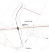
Yes it is. New bridge ID is OXD/24C, heres a screengrab from the TWA drawings:Good photos. Presumably this bridge is a replacement for the level crossing farm track from the village.
Attachments
Dr A.Johnston
Member
- Joined
- 6 May 2016
- Messages
- 50
Pictures from the the Phil March Twitter site @Marshrail
The route of HS2 where EWR intersects in the Claydon/Calvert area today, its good to finally see some pictures of this area and the development work going on.
Photo 1 - Looking towards Oxford from the intersection of HS2/EWR at Claydon

Photo 2 - Looking towards Bletchley from the intersection of HS2/EWR at Claydon

Photo 3 - Pathway of the old line section from Quainton to Claydon Junction

Photo 4 - Old Calvert Station looking toward old waste plant before complete obliteration.

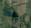
5. Map of area concered (look within the white squiggley line) - Goole Earth source
== Doublepost prevention - post automatically merged: ==
Again from the Phil March Twitter site @Marshrail
New, old and refurbished bridges at Claydon, Verney, Sandhills and Winslow today. Work positively racing on now with this project.
Photo 1 - Bridge at Claydon (Can be seen in the distance of Photo 1 of post 393 above)

Photo 2 - Bridge at Verney

Photo 3 - Bridge at Sandhills

Photo 4 - Bridge at Winslow

All photos are linked to source, hopefully this is the correct way of adding these. But a question, is it normal for two posts to merge together or did I do something wrong?
The route of HS2 where EWR intersects in the Claydon/Calvert area today, its good to finally see some pictures of this area and the development work going on.
Photo 1 - Looking towards Oxford from the intersection of HS2/EWR at Claydon
Photo 2 - Looking towards Bletchley from the intersection of HS2/EWR at Claydon
Photo 3 - Pathway of the old line section from Quainton to Claydon Junction
Photo 4 - Old Calvert Station looking toward old waste plant before complete obliteration.
5. Map of area concered (look within the white squiggley line) - Goole Earth source
== Doublepost prevention - post automatically merged: ==
Again from the Phil March Twitter site @Marshrail
New, old and refurbished bridges at Claydon, Verney, Sandhills and Winslow today. Work positively racing on now with this project.
Photo 1 - Bridge at Claydon (Can be seen in the distance of Photo 1 of post 393 above)
Photo 2 - Bridge at Verney
Photo 3 - Bridge at Sandhills
Photo 4 - Bridge at Winslow
All photos are linked to source, hopefully this is the correct way of adding these. But a question, is it normal for two posts to merge together or did I do something wrong?
Last edited:
swt_passenger
Veteran Member
- Joined
- 7 Apr 2010
- Messages
- 34,308
Linking posts is a normal forum feature if no-one has replied to your earlier post when you post again. See how (if you start a reply to your post) there’s a hidden “automerge” line has been added between the two posts?Pictures from the the Phil March Twitter site @Marshrail
== Doublepost prevention - post automatically merged: ==
Again from the Phil March Twitter site @Marshrail
All photos are linked to source, hopefully this is the correct way of adding these. But a question, is it normal for two posts to merge together or did I do something wrong?
swt_passenger
Veteran Member
- Joined
- 7 Apr 2010
- Messages
- 34,308
I posted a link in the earlier thread that became “EWR consultations”, I’ll try and find it again, here it is:I’m really sorry if it has been posted earlier, but would someone be able to share a link to the TWAO plans/section drawings please? I’ve seen them before, but I can’t for the life of me find them! Thank you.
East-West Rail (EWR): Consultation updates [not speculation]
This is what has been published so far on the service pattern. What will actually happen is just conjecture Route tph Calling at Oxford to Milton Keynes Central 2 Oxford Parkway, Bicester Village, Winslow, Bletchley Oxford to Bedford 1 Oxford Parkway, Bicester Village, Winslow, Bletchley...
 www.railforums.co.uk
Last edited:
fishwomp
Established Member
Thanks for sharing - minor correction, photos one and two are swapped. The first photo is looking east towards Bletchley (hence the distant new white concrete bridge at Steeple Claydon referred to subsequently), the second is looking towards Oxford.
Looking forward to seeing the rails rolling out this year!
Looking forward to seeing the rails rolling out this year!
The Planner
Veteran Member
- Joined
- 15 Apr 2008
- Messages
- 19,729
They will be moved down to Greatmoor, opposite to the waste to energy plant. The current ones will never return.Is there still to be rail sidings at Calvert or are they permanently gone?
swt_passenger
Veteran Member
- Joined
- 7 Apr 2010
- Messages
- 34,308
There’s a separate TWA order for new sidings at Greatmoor, as @The Planner just mentioned, there’s a link to the drawings in post #337.Is there still to be rail sidings at Calvert or are they permanently gone?
swt_passenger
Veteran Member
- Joined
- 7 Apr 2010
- Messages
- 34,308
Is picture 2 showing the start of a bridge to take Gawcott Rd under EWR, rather than over it as before? The spoil heap in the left background is visible on the current Google Streetview if you take up a position on the road bridge, I’m not sure if the road bridge has since been removed?Thanks for sharing - minor correction, photos one and two are swapped. The first photo is looking east towards Bletchley (hence the distant new white concrete bridge at Steeple Claydon referred to subsequently), the second is looking towards Oxford.
Looking forward to seeing the rails rolling out this year!
Ah, looking back at the drawing in post #317 I’m assuming this is going to be Charndon Lodge underbridge, ie road under rail.
Last edited:
fishwomp
Established Member
No - the brick bridge in the background of that (looking towards Oxford) is the Calvert to Gawcott Road. That's recently been renovated as part of the works, and is very much an overbridge still.Is picture 2 showing the start of a bridge to take Gawcott Rd under EWR, rather than over it as before? The spoil heap in the left background is visible on the current Google Streetview if you take up a position on the road bridge, I’m not sure if the road bridge has since been removed?
No, I think this is the supports for the bridge of HS2 passing under EWR.Ah, looking back at the drawing in post #317 I’m assuming this is going to be Charndon Lodge underbridge, ie road under rail.
swt_passenger
Veteran Member
- Joined
- 7 Apr 2010
- Messages
- 34,308
Have you compared with the current Google Streetview? I believe the HS2 crossing is well behind the photographer’s position for picture 2.No - the brick bridge in the background of that (looking towards Oxford) is the Calvert to Gawcott Road. That's recently been renovated as part of the works, and is very much an overbridge still.
No, I think this is the supports for the bridge of HS2 passing under EWR.
Dropped pin
fishwomp
Established Member
ooh... indeed I hadn't. I had my bridges mixed - it looks like they are messing with the bridge (massively!) at that Calvert-Gawcott section, perhaps making an underpass for the road. My bad! Last time I was out that way, in October, the road was shut for (ahem,. bridge work) so I actually posted photos from the next bridge along (west)..Have you compared with the current Google Streetview? I believe the HS2 crossing is well behind the photographer’s position for picture 2.
Dropped pin
At this point, EWR rises upwards and HS2 is to be in cutting, so that does make a lot of sense now.
swt_passenger
Veteran Member
- Joined
- 7 Apr 2010
- Messages
- 34,308
Thanks for replying. The EWR/HS2 crossing does seem a bit of a black hole in terms of detailed drawings, you probably realise already the EWR TWA drawings, (that I have posted extracts from a few times), just have an unexplained missing stretch through that area because the problem had already been given to HS2 to sort out.ooh... indeed I hadn't. I had my bridges mixed - it looks like they are messing with the bridge (massively!) at that Calvert-Gawcott section, perhaps making an underpass for the road. My bad! Last time I was out that way, in October, the road was shut for (ahem,. bridge work) so I actually posted photos from the next bridge along (west)..
At this point, EWR rises upwards and HS2 is to be in cutting, so that does make a lot of sense now.
What would probably be very useful here would be a drone overflight…
Thanks @swt_passenger for the kind reply - exactly what I was trying to find and much appreciated. I shall be able to track progress more clearly!I posted a link in the earlier thread that became “EWR consultations”, I’ll try and find it again, here it is:
So if you follow that Network Rail link you should find all the docs, I also included a direct link to the file which contains the western end bridge info.East-West Rail (EWR): Consultation updates [not speculation]
This is what has been published so far on the service pattern. What will actually happen is just conjecture Route tph Calling at Oxford to Milton Keynes Central 2 Oxford Parkway, Bicester Village, Winslow, Bletchley Oxford to Bedford 1 Oxford Parkway, Bicester Village, Winslow, Bletchley...
fishwomp
Established Member
Yes, true - we know the track to the east and west of the gap is to be fully laid by late summer (ish). The updates on https://sway.office.com/vKlm9Bv9obosHFEA?ref=Link&loc=play are superbly done and highly informative...Thanks for replying. The EWR/HS2 crossing does seem a bit of a black hole in terms of detailed drawings, you probably realise already the EWR TWA drawings, (that I have posted extracts from a few times), just have an unexplained missing stretch through that area because the problem had already been given to HS2 to sort out.
What would probably be very useful here would be a drone overflight…
.. and then there's the HS2 blackhole!
edwin_m
Veteran Member
The relevant HS2 plan is at https://assets.publishing.service.g...ile/529514/C222-ATK-CV-DPP-020-000009-FPD.pdf
swt_passenger
Veteran Member
- Joined
- 7 Apr 2010
- Messages
- 34,308
Yes that’s very like the drawing in post #317. I was meaning that HS2 doesn’t really provide the same detail as EWR have done.The relevant HS2 plan is at https://assets.publishing.service.g...ile/529514/C222-ATK-CV-DPP-020-000009-FPD.pdf
Dr A.Johnston
Member
- Joined
- 6 May 2016
- Messages
- 50
The attached PDF (now appearing at the bottom of this post) is from a on-line presenation from HS2 in July this year about what is happening at Calvert/Claydon and shows also the interconnections between HS2 depot and EWR and the new passenger loop. Line maintenance trains will be able to access the new Claydon/Calvert depot form either HS2 or EWR. Its about the best detail I have seen about this part of the EWR project.
== Doublepost prevention - post automatically merged: ==
A couple of videos appeared on You tube posted by Trains, Plains, Phones and drones, GRM Production
Mursley EWR railway update
Bletchley Flyover update
== Doublepost prevention - post automatically merged: ==
A couple of videos appeared on You tube posted by Trains, Plains, Phones and drones, GRM Production
Mursley EWR railway update
Bletchley Flyover update
Attachments
Last edited:
Dr A.Johnston
Member
- Joined
- 6 May 2016
- Messages
- 50
Its been quiet on here for a while, so here are some photos from Bletchley posted by Rugd1022 on the RM Web (Page 90)
At least progress is being made on preparation for the second track.


At least progress is being made on preparation for the second track.
Last edited:
richieb1971
Established Member
- Joined
- 28 Jan 2013
- Messages
- 2,047
2nd picture threw me off until I saw the gantries on the left.

swt_passenger
Veteran Member
- Joined
- 7 Apr 2010
- Messages
- 34,308
No, it’s not part of the current scheme.A quick question: there is a section of single track at both Fenny Stratford and Bedford St Johns. Will this be doubled for EWR? It looks like a tight fit from Google Maps.
Bletchleyite
Veteran Member
No, it’s not part of the current scheme.
This is one reason they want to close Fenny Stratford, as it lengthens occupation of the single track section. But bizarrely not St John's, which being so close to Midland has very little real value. Sure, it is well used, but I doubt closing it would result in a loss of passengers, it's mostly college kids who would moan a bit but walk from Midland. I can't help but think that someone involved in the scheme lives there.
This is slightly off: the currently consented scheme would not change the single track sections or close the stations at Fenny Stratford or Bedford St John’s.This is one reason they want to close Fenny Stratford, as it lengthens occupation of the single track section. But bizarrely not St John's, which being so close to Midland has very little real value. Sure, it is well used, but I doubt closing it would result in a loss of passengers, it's mostly college kids who would moan a bit but walk from Midland. I can't help but think that someone involved in the scheme lives there.
The most recent consultation in 2021 for the next phase suggested that both sections could be doubled and, potentially, one or both stations closed or relocated, but no decision has been taken on any of this and it has not been consented or funded as things stand.
richieb1971
Established Member
- Joined
- 28 Jan 2013
- Messages
- 2,047
On the St John's end they proposed double track using the Hitchin line bridge which is 2 arches over from the current St Johns Station. The curve would be faster and allow double tracking all the wat to Bedford. They even talked of using jowitt sidings.
On the Fenny end, they proposed double tracking all the way up to the flyover and building a 2nd bridge to accommodate it.
On the Fenny end, they proposed double tracking all the way up to the flyover and building a 2nd bridge to accommodate it.
If I recall correctly, in my response I said the options at St Johns would be better combined - having the southernmost station option would have a better catchment area, but having the alignment of the northern option would give the better speeds and save on the expensive new bridge. I can't see why they presented them as mutually exclusive unless they were doing the classic working backwards from their preferred option.
Bletchleyite
Veteran Member
If I recall correctly, in my response I said the options at St Johns would be better combined - having the southernmost station option would have a better catchment area, but having the alignment of the northern option would give the better speeds and save on the expensive new bridge. I can't see why they presented them as mutually exclusive unless they were doing the classic working backwards from their preferred option.
Though moving it south (if I'm getting the location right) would remove its current primary role*, as it'd be further from the colleges than Midland, so you'd want to be sure the new catchment would use it enough to be worth doing that over realigning and closing it.
* Rare to see anyone using it who doesn't look like a college kid, and they are in quite big numbers in so far as that line goes.
- Status
- Not open for further replies.