Well this isn't making sense, I thought there were a couple of open spaces, either side of the road where it could safely come down - Google maps to rescue, I've looked at there is a car park but then there are offices by the looks of it. So This is baffling me unless it's elevated for a majority of the city.
Hi,
I decided to go past the station in Nottingham to see where everything would fit. It's all quite simple in the end:
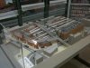
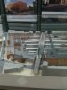
The tram follows the line of the GCR across Nottingham station and then crosses Queens Road on a bridge. This is shown in one of the images on "The Hub" gallery.
(I'd imagine that if the GCR bridge buttresses were left in the station that little work would be needed to re-use them. A tram has got to weigh a lot less than the heavy rail services that ran on the GCR!)
This allignment is clear of new office blocks (apart from a small structure within the station complex that's scheduled for demolition with the works anyway). At the moment there are a few advert hoardings and two old single story mini warehouses/workshops in the way. These could easily and cost-effectively be removed.
If you look on Multimap/Bing/GoogleMaps you can see the advert hoardings and the empty spaces curently used as a car park.
I don't know if this bit is elevated or if the tracks come down to street level. There are no engineering issues - just cost and traffic management.
The tracks cross Crocus Street and Arkwright Street at thier junction and then curve away to the allignment of Meadow Street. There's a handy bit of disused road in the park that shows the allignment. I am sure the tram would then run at street level.
Hope this helps visualise where it will all fit,
Jason