• Our new ticketing site is now live! Using either this or the original site (both powered by TrainSplit) helps support the running of the forum with every ticket purchase! Find out more and ask any questions/give us feedback in this thread!

What existed before the Routeing Guide?

Status
Not open for further replies.

Bletchleyite

Veteran Member
Joined
20 Oct 2014
Messages
113,691
Location
"Marston Vale mafia"
The correct name of the Routeing Guide is in fact the “electronic National Routeing Guide” - or eNRG. It was coded by Fujitsu in the mid 1990s following discussions with BR pricing managers. Somewhere I have got the original specification - I think from 1995. As has been observed, it was intended to ensure that carriers did not end up being forced to carry the passengers of ‘other’ TOCs. It predates online journey planning, but could (I assume) have been used locally in travel centres and booking offices equipped with Journey Planner (the Fujitsu software product that showed what itineraries were or were not valid for a given ticket).

The eNRG is a later implementation of it. The original NRG was a paper book.
 
Sponsor Post - registered members do not see these adverts; click here to register, or click here to log in
R

RailUK Forums

CE142

Member
Joined
23 Dec 2014
Messages
105
Before the Routing Guide it depended on two things, what ticket you had and if the Gripper was free or not!
 

TUC

Established Member
Joined
11 Nov 2010
Messages
5,088
Don't forget that in B.R. days all tickets were paper or card and carried routing usually in the form of 'via ...', an intermediate station on direct line of route.

For instance, a day return from Cardiff General to Barry had the words 'via Cogan or Lavernock', i.e., via either route of through trains. Tickets between Northampton (Castle) and Peterborough (East) were endorsed 'via Barnwell' to preclude travel via Rugby. With these endorsements it would be difficult to justify travelling by a more 'imaginative' route
The problem is that some of those description, even to this day, are not accurarate. I think I'm right in sayimg that Kings Cross to Selby tickets are still marked 'via Doncaster, when actually the restriction is 'not via York'. It would be perfectly reasonable for a passenger to think they had honoured the restriction by travelling on just about any ECML service and so travelled through Doncaster, and yet equally perfectly reasonably could think they could change for Selby at York.
 

deltic

Established Member
Joined
8 Feb 2010
Messages
3,719
There did use to be an equivalent of the routing guide in British Rail day- I have a copy of it somewhere but cannot find it at the moment . It was a far simpler version than the one now. Look at any old BR fares manual and on some routes you will find different fares depending on what route you took. Obviously it was not as complex as the present system but there were routing rules in the past.
 

Watershed

Veteran Member
Associate Staff
Senior Fares Advisor
Joined
26 Sep 2020
Messages
16,772
Location
UK
The problem is that some of those description, even to this day, are not accurarate. I think I'm right in sayimg that Kings Cross to Selby tickets are still marked 'via Doncaster, when actually the restriction is 'not via York'. It would be perfectly reasonable for a passenger to think they had honoured the restriction by travelling on just about any ECML service and so travelled through Doncaster, and yet equally perfectly reasonably could think they could change for Selby at York.
There are both "via Doncaster", as well as "Any Permitted" (and "Hull Trains only") fares. The "via Doncaster" fare is valid via all the same permitted routes as the "Any Permitted", except for some fairly niche routes such as Selby-Leeds-Wakefield-Sheffield-St Pancras.

The "via Doncaster" fare may be intended to mean "not via York". But it doesn't say that, and so travel via York is permitted on several of the mapped routes.

This is really a separate issue to the Routeing Guide though.
 

Andrew1395

Member
Joined
30 Sep 2014
Messages
666
Location
Bushey
I think the error was in trying to codify everything rather than making it recursive. Much simpler if, say, a London to Manchester ticket was just listed as valid via Chesterfield or Rugby, and then that'd recurse down to routes from London-Rugby + Rugby-Manchester etc.
Fares weren’t recursive.

Pre digital retailing with the introduction of the Rail Journey Information System,(eNRG was one part of the RJIS suite), the paper Routeing Guide was so little used (in terms of the totality of rail transactions and journeys), that it really did not matter that things had moved on from the any reasonable concept.

“Any Reasonable“ though depended on a human assessment by the staff interacting with the customer. Most customers wanted the make a journey as quickly and seamlessly as possible. Comparatively few were interested in the ability to use terms and conditions to come up with ways to make journeys that saved significant amounts of money or to enjoy discovering journey opportunities that were allowed but generally obscure to customers and staff. So a customer in 1986 turns up on Euston station concourse and asks where is the train to Derby? And is most likely to be told. You need to go to St Pancras. Rather than advised to go to Tamworth and change trains.

== Doublepost prevention - post automatically merged: ==

AIUI that is not true though, IIRC revenue distribution is based on non-overtaken journeys, so tickets are frequently valid on operators who will receive none of the revenue.
There would be i guess very few examples of tickets valid on trains that the carrier receives no allocation At all. I would guess it’s more likely to be the reverse. As ORCATS has no concept of Routeing or service quality. It will give even the tiniest percentage of a flow to operators who will never see a customer use that ticket on their services. In fact even on trains that the product is not valid on.
 
Last edited:

Haywain

Veteran Member
Joined
3 Feb 2013
Messages
24,774
The "via Doncaster" fare may be intended to mean "not via York". But it doesn't say that, and so travel via York is permitted on several of the mapped routes.
I don't really understand why the 'via Doncaster' routing exists, but I am certain that if it was intended to bar travel via York it would do so by being 'not via York'.
 

Andrew1395

Member
Joined
30 Sep 2014
Messages
666
Location
Bushey
As I understand it, the Routeing Guide was created at privatisation as part of the whole TSA and Peterborough Agreement, to find some sensible way to issue tickets across TOCs/TOUs, agree settlement etc.

I believe that the Routeing Guide itself wasn't always available from ATOC/RDG until they were made to publish it, but perhaps I'm wrong on that?

Presumably the Routeing Guide, as created, was based on some internal BR equivalent? Was that accessible to passengers?

I'm aware of the existence of the NFMs and of course these have direct equivalents today.

I'm also interested in whether the 'anomalous routes' exist purely as a result of privatisation codifying bad data.
The Routeing Guide was created in 1995 by a secretariat of BR working on what practical arrangements needed to be created to implement the lawyers deliberations, that ultimately led to the Ticketing & Settlement Agreement. Most of the staff ended up in ATOC although others went back to BR Operational Research which was privatised and now through several changes in ownership is Resonate.

The Routeing Guide was based on a booklet that a staff member was leafing through one day at home. It was the AA members handbook that included schematic maps of the UK motorways with each motorway junction described to show if you could join and exit at that motorway junction or just exit or just join the route at that junction. Each junction listed the A roads and motorways that interacted at the junction and where those intersections ultimately led to and joined other schematic journey maps.

that led to the concept of Routeing points and associated locations (stations) and how you could use Routeing points to create maps, and how to join up maps to create journeys across the whole network.

later they then applied other concepts that took into account product rules and pricing. fares checking, etc.it was done relatively quickly, but took another year or so of review with the regulators. So became operational in September 1996.
 

alistairlees

Established Member
Joined
29 Dec 2016
Messages
4,413
The Routeing Guide was created in 1995 by a secretariat of BR working on what practical arrangements needed to be created to implement the lawyers deliberations, that ultimately led to the Ticketing & Settlement Agreement. Most of the staff ended up in ATOC although others went back to BR Operational Research which was privatised and now through several changes in ownership is Resonate.

The Routeing Guide was based on a booklet that a staff member was leafing through one day at home. It was the AA members handbook that included schematic maps of the UK motorways with each motorway junction described to show if you could join and exit at that motorway junction or just exit or just join the route at that junction. Each junction listed the A roads and motorways that interacted at the junction and where those intersections ultimately led to and joined other schematic journey maps.

that led to the concept of Routeing points and associated locations (stations) and how you could use Routeing points to create maps, and how to join up maps to create journeys across the whole network.

later they then applied other concepts that took into account product rules and pricing. fares checking, etc.it was done relatively quickly, but took another year or so of review with the regulators. So became operational in September 1996.
Thank you. A very useful piece of first hand history there.
 

Merle Haggard

Established Member
Joined
20 Oct 2019
Messages
3,969
Location
Northampton
The problem is that some of those description, even to this day, are not accurarate. I think I'm right in sayimg that Kings Cross to Selby tickets are still marked 'via Doncaster, when actually the restriction is 'not via York'. It would be perfectly reasonable for a passenger to think they had honoured the restriction by travelling on just about any ECML service and so travelled through Doncaster, and yet equally perfectly reasonably could think they could change for Selby at York.

I was told once that the reason for some of the via points was the regional boundary - for instance, the example I quoted on the Northampton -Peterborough route was the LM/ER boundary. I'm possibly thinking too deeply, but could the regional boundary indication be something retained from company days? Presumably for the allocation of receipts by the R.C.H. between companies it would be important to specify the 'border crossing'. In the case of Doncaster, it might be to ensure the G.N.R. / N.E.R. boundary was crossed just North of Doncaster rather than via some other route. The boundary was between Arksey and Moss, not sure exactly where, but they were the 1st and 2nd stations North of Doncaster on the East Coast. If one travelled via Doncaster, that was the only boundary it was possible to cross by.

Old customs did get carried over, but I'm just making a suggestion.
 

greyman42

Established Member
Joined
14 Aug 2017
Messages
5,368
Essentially, yes.
I once tried to return from Glasgow to Berwick on a day return ticket via Carlisle and Newcastle, the guard essentially said "come off it, that's not sensible" and so we paid up. In fact we paid for a day return Glasgow-Carlisle and went back to Glasgow before going back to Berwick on a more sensible route. No complaints by anyone.
I doubt York to Birmingham via Crewe would of been deemed reasonable before the routing guide.
 

JB_B

Established Member
Joined
27 Dec 2013
Messages
1,564
I doubt York to Birmingham via Crewe would of been deemed reasonable before the routing guide.
Maybe not but it's less than 20% further than the shortest route (via Tamworth) and in no way obviously unreasonable.
 

Bletchleyite

Veteran Member
Joined
20 Oct 2014
Messages
113,691
Location
"Marston Vale mafia"
I doubt York to Birmingham via Crewe would of been deemed reasonable before the routing guide.

It's a bit circuitous, but I don't think it's way off on the basis that I'd definitely say it was reasonable via Manchester, and generally on the WCML all the branches and loops are fair game (and so they should be). Probably as far west as you should reasonably go.

Because XC often overprice fares, though, if you are going via Manchester (whether also via Crewe or not) a split may be cheaper. But that doesn't detract from the point.
 

Haywain

Veteran Member
Joined
3 Feb 2013
Messages
24,774
I was told once that the reason for some of the via points was the regional boundary - for instance, the example I quoted on the Northampton -Peterborough route was the LM/ER boundary. I'm possibly thinking too deeply, but could the regional boundary indication be something retained from company days? Presumably for the allocation of receipts by the R.C.H. between companies it would be important to specify the 'border crossing'. In the case of Doncaster, it might be to ensure the G.N.R. / N.E.R. boundary was crossed just North of Doncaster rather than via some other route. The boundary was between Arksey and Moss, not sure exactly where, but they were the 1st and 2nd stations North of Doncaster on the East Coast. If one travelled via Doncaster, that was the only boundary it was possible to cross by.

Old customs did get carried over, but I'm just making a suggestion.
As mentioned before what happened in the 1950s isn't terribly relevant to to this.
 

alistairlees

Established Member
Joined
29 Dec 2016
Messages
4,413
Back on topic, here is a link to the paper routeing guide from July / August 1996 (the pages seem to have different dates on them).


It is 233 pages long! As a result I cannot attach the PDF file ("server error: too large")

== Doublepost prevention - post automatically merged: ==

This letter (on the ORR website) refers to "Version 8 of the Routeing Guide" dated 29 September 1996


Attachments

  • Office of the Rail Regulator letter re Routeing Guide, September 1996 00000002_4147.pdf
    103.4 KB · Views: 10
Last edited:

lyndhurst25

Established Member
Joined
26 Nov 2010
Messages
1,591
I like him there are only SIXTEEN easements in the 1996 Routing Guide (and some of them are duplicates). Things seem to have got a lot more complicated since then.
 

JB_B

Established Member
Joined
27 Dec 2013
Messages
1,564
Back on topic, here is a link to the paper routeing guide from July / August 1996 (the pages seem to have different dates on them).


It is 233 pages long! As a result I cannot attach the PDF file ("server error: too large")

== Doublepost prevention - post automatically merged: ==

This letter (on the ORR website) refers to "Version 8 of the Routeing Guide" dated 29 September 1996


Thanks for the links - really interesting to see a complete early example.

This site...


... is another useful resource for anyone interested in the history of the routeing guide.

== Doublepost prevention - post automatically merged: ==

I like him there are only SIXTEEN easements in the 1996 Routing Guide (and some of them are duplicates). Things seem to have got a lot more complicated since then.

Yes, just 16 and apparently they really were "easements" in those days; the "negative easement" had yet to be invented.

I'm not sure when negative easements came in but they seem to have arrived somewhere between 1997 and 2003.
 

AM9

Veteran Member
Joined
13 May 2014
Messages
16,054
Location
St Albans
I think that doubling back near large city stations vs direct was often discriminated by separate tickets, e.g. Watford to Manchester was travelling northwards unless the ticket was labelled Watford to Manchester via Euston. There was also an Ilford to Norwich and Ilford to Norwich via Liverpool St, and the fare was the same for both option in each case. Presumably, it was better for passenger and connection management to get passengers on the fastest train by allowing boarding at it's origin, - they were both the same provider.
 

Paul Kelly

Verified Rep - BR Fares
Joined
16 Apr 2010
Messages
4,234
Location
Reading
Fundamentally, there isn't a published predecessor to the Routeing Guide. It was only created on privatisation
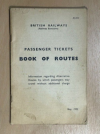
That's not really true - a similar-ish situation arose on nationalisation and the "Book of Routes" was published a few years afterwards in 1952 - you can sometimes see it for sale on Ebay. As it performed the exact same purpose I feel it can be considered a predecessor. It is not as comprehensive as the Routeing Guide and doesn't attempt to define a route for every journey - rather consists of lists of available routes between various pairs of stations where ambiguity might exist.
There did use to be an equivalent of the routing guide in British Rail day
Yes, you might be thinking of the Book of Routes?
 

maniacmartin

Established Member
Fares Advisor
Joined
15 May 2012
Messages
5,438
Location
Croydon
I have seen the Book of Routes in the past. Unlike the modern Routeing Guide, it is recursive
 

mikeg

Established Member
Joined
20 Apr 2010
Messages
2,071
Location
Selby
I have seen the Book of Routes in the past. Unlike the modern Routeing Guide, it is recursive
There definitely was a BR Book of Routes at one point. The question is, when did it come in and when was it abolished? Also was it a hangover from Railway Clearing House days and if not, how did the RCH calculate permitted routes?
 

kieron

Established Member
Joined
22 Mar 2012
Messages
3,286
Location
Connah's Quay
There are both "via Doncaster", as well as "Any Permitted" (and "Hull Trains only") fares. The "via Doncaster" fare is valid via all the same permitted routes as the "Any Permitted", except for some fairly niche routes such as Selby-Leeds-Wakefield-Sheffield-St Pancras.

The "via Doncaster" fare may be intended to mean "not via York". But it doesn't say that, and so travel via York is permitted on several of the mapped routes.
I'm afraid the routeing guide says otherwise:

030048 (circuitous route) Journeys from Kings Cross, Peterborough, Grantham, Newark North Gate and Retford to Selby, Wressle, Howden and Eastrington may not travel via York on tickets routed via Doncaster. This easement applies in both directions.

There are route codes which have restrictions on-line which neither the text on the ticket nor the routeing guide backs up, but I know how quickly the rail industry can resolve discrepancies like that.
 

deltic

Established Member
Joined
8 Feb 2010
Messages
3,719
There definitely was a BR Book of Routes at one point. The question is, when did it come in and when was it abolished? Also was it a hangover from Railway Clearing House days and if not, how did the RCH calculate permitted routes?

A copy is presently on sale on Ebay
 

Attachments

  • 1671566516939.png
    1671566516939.png
    248.6 KB · Views: 43

yorkie

Forum Staff
Staff Member
Administrator
Joined
6 Jun 2005
Messages
78,435
Location
Yorkshire
I have an old routeing guide/book of routes somewhere; at some point I will see if I can find it...

== Doublepost prevention - post automatically merged: ==

Regarding distance, the shortest route is always valid regardless of the mapped routes and there is no need to refer to the Routeing Guide when following the shortest route.

A route that is shorter than the shortest route by rail (e.g. Bedford to Watford Jn by the fixed link between St Albans City/Abbey) or is longer than the shortest route by no more than 3 miles would also be valid, but it's generally accepted that such routes are at the mercy of "negative easements".
I have a feeling it's been the cause of some bugs in the past, where new stations have had 'zero distance' in the data and caused journey planners to do interesting things. I am probably misremembering.
I think the example you may be referring to isn't in the public domain so I won't refer to that detail here.
 
Status
Not open for further replies.

Top