Our new ticketing site is now live! Using either this or the original site (both powered by TrainSplit) helps support the running of the forum with every ticket purchase! Find out more and ask any questions/give us feedback in this thread!
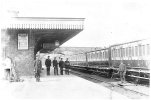
I'm the Project Leader for 'Capturing the Past' - an archive website of material about the Yorkshire Dales. A contributor has submitted this photo as "Unknown Station on Settle & Carlisle Railway (probably Skipton)".
It isn't Skipton and local opinion says it isn't the Settle to Carlisle line either. Does anyone recognise the style of station? The contributor does not give an exact date - simply circa 1900.
The maps on the National Library of Scotland site, for example https://maps.nls.uk/view/126514712 show a considerable gap between the road overbridge and the ends of the platforms at Kirby Lonsdale, the bridge crossed the line on a skew, and finally that the station building was on the outside of the curve at this location. So I don't think it's Kirby Lonsdale.
If this is Skipton station, it is platform 5 or 6 on the former Ilkley line added in 1888. The other platforms of Skipton station, dating from 1876 seem generally too curved to line up with the bridge in the background and in any case have typical Midland Railway "ridge and furrow" canopies over all platforms. There seems to be another bridge, probably only a footbridge, in the distant background. Track layout plans I have seen do not explain why there is a ground frame on the platform; presumably the rodding or cables pass under the board the man between the tracks is standing on, but there seem to be no points in the immediate vicinity. If they operated platforms signals, would that have been allowed at what was quite a complicated junction?
My first impression on looking at the photograph was that it was an L&YR station. I have little knowldege of railway rolling stock, so someone may be able to shoot that down instantly.
== Doublepost prevention - post automatically merged: ==
Sent the photo to a pal. Heres is his note…….My immediate thought was thats LNWR as only know about that line. it's LNWR. It certainly isn’t Skipton, nor anywhere else on the Settle & Carlisle. As you say, it’s LNWR – or at least they’re LNW carriages, that looks like an LNW tank engine at the far end and the station lamp, roof valance and signboards look like LNW items.
I wonder if this is the LNWR station at Ingleton? A look at https://maps.nls.uk/view/125630374 indicates this had a station building and bridge in the positions relative to the platform that are visible in the photo. No signal box is marked as such, but 25inch:1mile maps didn't always get the detail correct. But the absence of a marked signal box might explain the presence of the ground frame?
I wonder if this is the LNWR station at Ingleton? A look at https://maps.nls.uk/view/125630374 indicates this had a station building and bridge in the positions relative to the platform that are visible in the photo. No signal box is marked as such, but 25inch:1mile maps didn't always get the detail correct. But the absence of a marked signal box might explain the presence of the ground frame?
I imagine the pink building at the end of the Up platform is the SB? In which case the GF is odd, but I can't think of an alternative unless it's on the LNW main line or Windermere branch.
I imagine the pink building at the end of the Up platform is the SB? In which case the GF is odd, but I can't think of an alternative unless it's on the LNW main line or Windermere branch.
That crossed my mind as well. But I recall reading (can't recall the source) that there was a dispute between the LNWR and MR over running through trains at Ingleton for some time (each having their own station). The map I linked to is dated 1895 by which time I think they'd come to some form of agreement. If the photo was taken before agreement was reached that might explain why the train and loco appear to be about to do a wrong-line move, and they may not have yet built a box until the dispute was sorted out and they knew what facilities were needed? But looking at the less detailed 6inch:mile map of 1851 that possible signal box is present, although the function of the building remains unmarked.
A quick look at a map rules out any station on the Windermere branch - none have a road bridge over the line in close proximity to the platforms as in the photo.
I wonder if this is the LNWR station at Ingleton? A look at https://maps.nls.uk/view/125630374 indicates this had a station building and bridge in the positions relative to the platform that are visible in the photo.
I doubt this is Ingleton (Thornton-in-Lonsdale).
The map you have linked to suggests that the second overbridge wouldn't be visible from the point the photograph was taken from. Google maps seem to suggest likewise.
I doubt this is Ingleton (Thornton-in-Lonsdale).
The map you have linked to suggests that the second overbridge wouldn't be visible from the point the photograph was taken from. Google maps seem to suggest likewise.
The OS map implies a canopy on 3 sides of the station building, which is consistent with the photo. I must say it is very generous provision for a small town.
I wonder if it is completely mislabelled and is actually in completely different part of the country.
The mix of stone overbridge and brick building with a canopy that has slats made me think of some of the LSWR West Country stations. It would also explain the mix of carriage heights if they had come from different constituent companies.
There's a pic of the Ingleton LNW station (taken from the other end of the platform) in Martin Bairstow's "The 'Little' North Western Railway" (2018 book). The station building canopy and signage certainly looks like it could well be the same location as the one upthread in the "mystery" photo.
Ingleton LNW station closed in late 1916 as a "temporary" war time economy, so that must date the OP's photo as some time before then.
There's a pic of the Ingleton LNW station (taken from the other end of the platform) in Martin Bairstow's "The 'Little' North Western Railway" (2018 book). The station building canopy and signage certainly looks like it could well be the same location as the one upthread in the "mystery" photo.
Ingleton LNW station closed in late 1916 as a "temporary" war time economy, so that must date the OP's photo as some time before then.
Sorry, I concur with 30907. I can see what you mean but, if you are thinking of the shape behind the right shoulder of the person 2nd from the left in the picture (beyond the stone bridge), I think this is the land contour.
just for correction - the community centre is the south (Midland) station, and the photo is definitely not there.
What is noticeable is that while the bridge is stone. the station building appears to be very rough water damaged brickwork with bad repointing and possibly even partial replacement with unmatched bricks
Sorry, I concur with 30907. I can see what you mean but, if you are thinking of the shape behind the right shoulder of the person 2nd from the left in the picture (beyond the stone bridge), I think this is the land contour.
Sorry, I concur with 30907. I can see what you mean but, if you are thinking of the shape behind the right shoulder of the person 2nd from the left in the picture (beyond the stone bridge), I think this is the land contour.
I think there's a good chance there's a second bridge there, either wider or at more of an angle to the camera ( or both ) so there's more of the dark underside of the arch visible. There's some impression of the architectural "pillar" feature from the front bridge too.
On the other hand I can see it as the start of a cutting too. This is not the best scanned image ever!
It looks like the scanner (either the person or the actual device) has attempted to sharpen/retouch the image, and some detail has been lost. It might be worth posting a 'raw' .jpg image as different settings will tend to highlight detail in different parts of the image, which can be used to identify features. Contributers can then play around and see if anything else can be extracted
I was wondering if the canopy valance ( daggerboard ) design could be distinctive enough to be a clue. I couldn't immediately spot anything similar in nearby Little NW and Midland stations.
( If anything, the closest matches seemed to be in GWR territory. )
I was wondering if the canopy valance ( daggerboard ) design could be distinctive enough to be a clue. I couldn't immediately spot anything similar in nearby Little NW and Midland stations.
( If anything, the closest matches seemed to be in GWR territory. )
Possibly a typo in Martin Bairstow's book, as mentioned in post #16, as he does also mention Ingleton (LNWR) station on a previous page, presume it's the same station, i.e. the one that closed in 1916.

 date - simply circa 1900.


