
• Our new ticketing site is now live! Using either this or the original site (both powered by TrainSplit) helps support the running of the forum with every ticket purchase! Find out more and ask any questions/give us feedback in this thread!

Storm Dylan Sunday 31st

Status
Not open for further replies.

gavin

Member
Joined
25 Dec 2006
Messages
1,006
Storm Dylan is forecast to arrivng later today with the greatest impacts expected tomorrow morning an amber warning is in force for
  • Northern Ireland
  • SW Scotland, Lothian Borders
  • Strathclyde
Wind gusts of 70 to 80mph are likely in these areas extended journey times and cancellations are likely

Storm Dylan is expected to develop in the east Atlantic on Saturday night then track northeastwards close to Northern Ireland and into Scotland on New Years Eve. This will bring some very strong winds to these areas with gusts of 55-65 mph expected for many parts and a short period of gusts of 70-80 mph for some places. The winds will ease from the west as the low continues to move northeast, winds easing down in the early afternoon.

https://www.metoffice.gov.uk/public/weather/warnings#?date=2017-12-31

A yellow wind warning is also in force for larger parts of northern England, northern Ireland and parts of Scotland

An area of low pressure is expected to develop in the east Atlantic then on Saturday night then track northeastwards close to Northern Ireland and into Scotland on New Years Eve. This will bring some very strong winds to these areas with gusts of 55-65 mph expected and the potential for gusts of 70-80 mph in some places. The winds will ease from the west as the low continues to move northeast, winds easing down by late afternoon. There remains some uncertainty in the track of this low system and so the areas affected by the core of strongest winds. However, not all of the warning area is likely to be affected.

https://www.metoffice.gov.uk/public/weather/warnings#?date=2017-12-31
 
Sponsor Post - registered members do not see these adverts; click here to register, or click here to log in
R

RailUK Forums

Carntyne

Member
Joined
8 Jul 2015
Messages
1,024
Scotrail have retweeted the met office warnings it might not be until later today travel info for tomorrow is released
Then journey time extensions and cancellations are not expected, not sure why you would announce to the contrary. It’s incorrect.
 

gavin

Member
Joined
25 Dec 2006
Messages
1,006
Then journey time extensions and cancellations are not expected, not sure why you would announce to the contrary. It’s incorrect.

Within the warnings

Longer journey times and cancellations are likely as road, rail, air and ferry services may be affected. Some roads and bridges are likely to close.
 

al78

Established Member
Joined
7 Jan 2013
Messages
2,600
The Met Office don't operate the railway remember.

No, but they do advise on possible transport disruption, they don't need to operate the railway to do that, they only need to look at historical storms of similar intensity. You don't need to be an expert in railway operation to know that winds strong enough to blow down trees have a good chance of disrupting rail journeys (trains can't go over trees).
 

gavin

Member
Joined
25 Dec 2006
Messages
1,006
Then journey time extensions and cancellations are not expected, not sure why you would announce to the contrary. It’s incorrect.

Well would you believe it trains are disrupted this morning good job I posted the warning yesterday...

High winds and heavy rain in the Craigendoran area has resulted in trains being unable to run between Helensburgh Central and Dumbarton Central. Disruption is expected until approximately 14:00.

Buses have been requested to operate between Helensburgh Central and Dumbarton Central, but these are yet to be confirmed.

Due to high winds between Kilwinning and Ardrossan South Beach trains are unable to run between Kilwinning and Ardrossan Harbour / Largs. Disruption is expected to continue until approximately 14:00.

Buses operated by Coast to Coast are running between Kilwinning and Ardrossan Harbour / Largs.

http://www.nationalrail.co.uk/service_disruptions/today.aspx
 

sigma421

Member
Joined
10 Oct 2015
Messages
54
Train has hit a tree between Stirling and Alloa so that line is closed for the moment
 

gavin

Member
Joined
25 Dec 2006
Messages
1,006
The line at Craigendoran did reopen but it has had to close again due to continued heavy rain and strong winds
 

Groningen

Established Member
Joined
14 Jan 2015
Messages
2,866
For tonight from 3.00 to 18.00 we have in the Netherlands again a code yellow, because of high wind speeds.
 

InOban

On Moderation
Joined
12 Mar 2017
Messages
4,537
And we have Eleanor tonight, on much the same track, and we've now reached spring tides - full moon last night.
 

Groningen

Established Member
Joined
14 Jan 2015
Messages
2,866
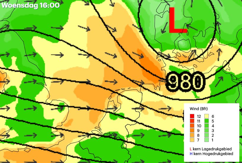
This i received from 1 of our weathersources in the Netherlands. Luckely Low (english) and Laag (Dutch) starts both with a L. The centre will pass just north of the Netherlands. The wind will be strongest at 10 in the morning; the L will be than directly above the Netherlands.

DShMZilXcAA7OUd.jpg
 

infobleep

On Moderation
Joined
27 Feb 2011
Messages
13,451
Eleanor is currently raging outside.

I was checking the trains online when I saw the following:
Other Information

Please be aware that platforms may become slippery due to expected rain and blown leaves. Care should be taken when travelling on platforms and stations. You are advised to stand behind yellow lines for your safety.
http://m.nationalrail.co.uk/pj/disruption/details/4BAB9C494D3244FF93A99C6E8C643796

I don't know if travelling on platforms and stations is grammatically correct but it sounded odd and made me a laugh. I won't claim to be perfect myself with grammar and spelling. Edit: I think it is correct but it still made me laugh as I think of travelling on trains and not platforms and stations. I had visions of stations physically moving.

Incidentally it seems this storm is only affecting South Western Railway and Southern, along with the trains into Paddington, as something hit the overhead wires, and trains in Wales. The Wales issue affects Various Arriva Trains Wales, Great Western Railway and Virgin Trains routes

I'd have thought South Eastern might be affected and the wider Great Western Railway network but no mention of them on National Rail Enquiries, Paddington disruption and Wales aside.

The Wales disruption could be up to 90 minutes. Not looking so bad elsewhere, assuming no trees come down.
 

al78

Established Member
Joined
7 Jan 2013
Messages
2,600
According to the local radio, trees have come down across Sussex and Surrey, and speed restrictions are in place on the railway near Redhill.
 

a_c_skinner

Established Member
Joined
21 Jun 2013
Messages
1,700
Interesting the bulk of the general domestic disruption seems to have been further south than the Met Office's amber warning.
 

infobleep

On Moderation
Joined
27 Feb 2011
Messages
13,451
Some trains have been delayed today but speed restriction, speed restriction caused by high winds, server weather or delayed by no individual reason given.

Then there is the 6:40 Littlehampton to Victoria service. Someone was obviously expecting that to be delayed. After all it goes along the coast and there are speed restrictions. So there is a notice saying this train has been delayed due to a speed restriction caused by high winds. However it ran to time perfectly through out.

That is extremely rare, server weather or no server weather.
 
Last edited by a moderator:

Groningen

Established Member
Joined
14 Jan 2015
Messages
2,866
High winds or even a tornado has blown a train out of the tracks in Switzerland.

70

Source: Aargauer Zeitung
 

Groningen

Established Member
Joined
14 Jan 2015
Messages
2,866
Strangest thing is that the front part of the train derailed and the back part travelled for another 50 meters.
 
Status
Not open for further replies.

Top