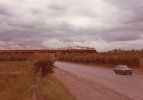
Based mainly on the style of the bridge (in particular the abutments), I was wondering whether it could be the A6 at Templepatrick, east of Antrim - probably looking west. (The present-day Google Street View is at
https://www.google.com/maps/@54.704...4!1scS6ZsI6hVSbwCb_4avFVxA!2e0!7i16384!8i8192; there's also a close-up of the bridge at
https://www.geograph.ie/photo/4115135). Additionally, the itinerary at
https://www.steamtrainsireland.com/members/galleries/93/south-wexford-railtour-1978 says WT no. 4 worked the relevant leg of the tour, from Dublin Pearse to Whitehead on Monday 12th June (but see the comment regarding dates below).
However, there are a few issues with this - the parapet seems too low in the photo (but it could have been raised since 1978, especially given that the line was extensively rebuilt before it reopened to passengers around the turn of the millennium, and it's possible that the entire bridge deck was replaced), the Street View shows a stone wall on the right that looks as though it should have been there in 1978 but doesn't seem to be in the photo, and the handwritten date looks more like 10/6/78 than 12/6/78 (though I wouldn't rule out the latter, or a mistake - particularly given that the 10th was the first day of the tour).
According to the above itinerary, no. 4 was hauling the tour on the 10th (Dublin Connolly - Dublin Heuston ECS, then Dublin Heuston - Limerick Junction - Carrick-on-Suir and Waterford - Rosslare Strand - Wexford South), but I'm having trouble finding a location that fits with the photo (beam-type underbridge crossing what looks like a fairly important road by the standards of either part of Ireland in 1978, not in a built-up area at the time) on those routes.