• Our new ticketing site is now live! Using either this or the original site (both powered by TrainSplit) helps support the running of the forum with every ticket purchase! Find out more and ask any questions/give us feedback in this thread!

Narrow gauge in Bermondsey

Status
Not open for further replies.

Shimbleshanks

Established Member
Joined
2 Jan 2012
Messages
1,283
Location
Purley
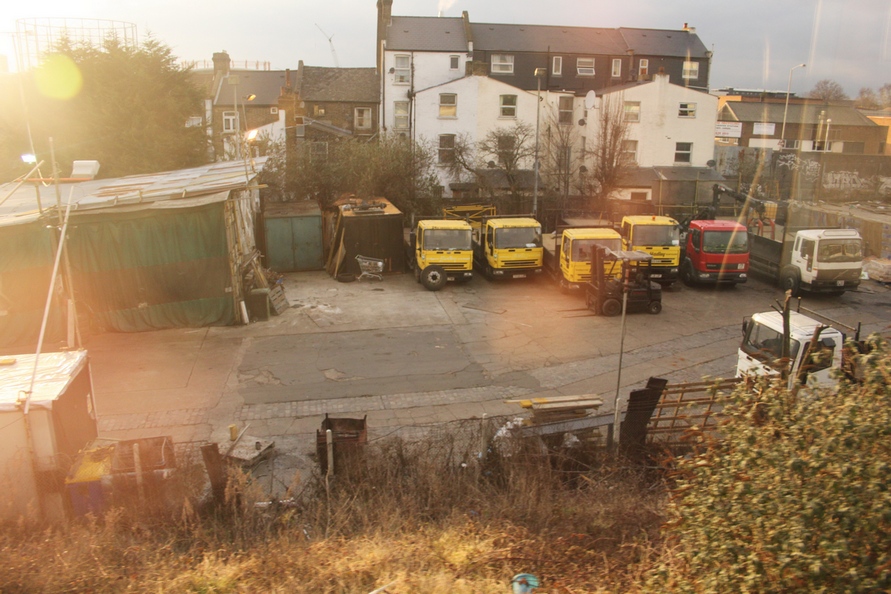
I was on a train between Queens Road Peckham and South Bermondsey the other day sitting on the left side of the train as we headed towards London Bridge (ie looking out on the west side of the line). Around 200-400 yards or so before South Bermondsey station, below the viaduct, I spotted some narrow gauge pointwork inset into what looked like a haulage yard or similar. From where I was sitting, it looked about two-foot gauge, maybe 2ft 6in.

I have looked on Google Maps but can't find any sign of it. Either the level of detail isn't high enough or, possibly, the ground was covered by a building that has been demolished in between the Google image being taken and my sighting.

I'm planning to do another recce soon, but does anyone have any idea what it was? Obviously, not a passenger street tramway - too narrow a gauge. Presumably some sort of industrial concern.
 
Last edited:
Sponsor Post - registered members do not see these adverts; click here to register, or click here to log in
R

RailUK Forums

ntg

Member
Joined
27 Sep 2010
Messages
123
Location
Potters Bar, Herts
Where approximately on the map is it? Any luck with street view? Its images are more up to date.

That area is riddled with disused track beds and defunct alignments.
 

Shimbleshanks

Established Member
Joined
2 Jan 2012
Messages
1,283
Location
Purley
Where approximately on the map is it? Any luck with street view? Its images are more up to date.

That area is riddled with disused track beds and defunct alignments.

Yes, I've tried Street View and can't see anything that looks like it. Best way to describe it is to follow the track that leads from Queen's Road Peckham station to South Bermondsey station, and the yard was to the left of the 'up' line as you head towards South Bermondsey or London Bridge. (And it's the line that actually goes through those two stations, not any of the tracks that bypass them.) As you say, the area is a real cat's cradle of different lines.
 

John Webb

Established Member
Joined
5 Jun 2010
Messages
3,765
Location
St Albans
Could this have been an internal rail system for a timberyard or the like on the banks of the old Surrey Canal? (Surrey Canal Road is built on the line of the canal.)
 

pendolino

Member
Joined
22 Nov 2010
Messages
737
I went that way twice today, but both times on the down so couldn't get a brilliant view. However, I'm pretty sure I saw what you're referring to: narrow gauge tracks with pointwork and cobbles/setts between the rails in some sort of haulage yard.

I've had a look in the A-Z but can't work out exactly where it was, but having had a quick look on some old maps of the area, there were a number of tramlines, and on one map a 'tram stables' on Surrey Canal Road. I don't think this is exactly the same place, but I'm intrigued now, so I might have a wander up there later to have a look.

There are a few other places around London where tramlines still exist (no, I don't mean Croydon) - the bus garage at the top of Brixton Hill still has the tram tracks set into the floor, and 'LCC' over the door. So it's a possibility, but not a certainty that this is what you've seen in Bermondsey.

edit: just noticed what you said about tramways, and this being too narrow a gauge. Were horse drawn trams standard 4ft 81/2" gauge? Anyone know?
 
Last edited:

Shimbleshanks

Established Member
Joined
2 Jan 2012
Messages
1,283
Location
Purley
Many thanks for all your responses - and I'm glad someone else appears to have seen it too, so I haven't been imagining things! Can't seem to pin it down on any of the maps I've been sent - those that I can access at any rate.

On the subject of tramways, I'm not aware of any that were to such a narrow gauge (other than the Seaton one which is a latter day development). Narrowest I can recall were 3'6" though the vast majority were 4' 8 1/2' as were all or most of London's I believe. I must say an internal system for some industrial concern seems the most likely explanation - after all, they were common enough until the 1970s.
 

John Webb

Established Member
Joined
5 Jun 2010
Messages
3,765
Location
St Albans
The Greenwich-Woolwich-Plumstead horse tram was only 3ft 6in gauge. But the Pimlico, Peckham and Greenwich Street Tramways Co. was a standard gauge line.

There appears to have been a narrow gauge railway system south of the canal, but several roads to the west of the railway line used by the OP, in the Metropolitan Gas Works that used to exist - StreetView for Devon Street shows that there are some gas holders still in existance. But the aerial photos in Google show no trace of this track - most of the gasworks site now seems to be industrial estates.
 

pendolino

Member
Joined
22 Nov 2010
Messages
737
I've just been to have a look. The tracks are in a scaffolder's yard accessed from Rollins Street, but running northwards to Surrey Canal Road. A bit further north than the Old Kent Road which is roughly where I thought they were when I went past earlier today, which rules out trams, horse drawn or otherwise.

I spoke to a man working there who probably thought I was very strange but he thinks they were for unloading cargoes from barges on the old Surrey Canal (as suggested up thread by John - there are still a few timber yards around there) which, according to him was still there 30 years ago. He didn't know what sort of cargo though.

I asked if I could nip in to take some photos, but he was just locking up so had to say no which is fair enough, but I did get a picture from the entrance of some cobbles which might or might not be part of the 'tramway'. I'll post it up later when I get home.

From the train though, you can definitely see some rails, including a crossover between two sets of tracks.
 

bangor-toad

Member
Joined
20 Feb 2009
Messages
671
Hi there,
If you use Bing maps and use the Birds eye view you can just make out the tracks embedded in the yard next to the railway embaankment as described. To see them though you need to go to maximum zoom and the rotate by 180 degs.

The track looks to be about a 3 foot gauge.

This matches the old records for the South Metropolitan Gas Company Old Kent Road Works industrial railway. This was 3ft gauge system that was used to move materials between the Grand Surry Canal and the gasworks. The route of the canal is actually across the northern end of the yard with the tracks and the main railway crosses the path of the canal (now a road) on an overbridge. The gas works still exist about 500m further to the west.

I think this is what you've seen.

[Edit - this seems to match what Pendolino has been told]
Cheers,
Jason
 

Shimbleshanks

Established Member
Joined
2 Jan 2012
Messages
1,283
Location
Purley
Interesting stuff - those replies should save me a lot of leg work in terms of tracking the place down. I only hope I can get there before the scaffolder gets fed up with all the visits from railway buffs!
 

HSTEd

Veteran Member
Joined
14 Jul 2011
Messages
20,315
Would approximately two foot gauge tend to indicate that it may have been operated by surplus War Department Light railway equipment or is that just silly?
 

pendolino

Member
Joined
22 Nov 2010
Messages
737
Pictures:

From the entrance

img_1447.jpg


Then 3 quite frankly terrible pictures taken through the sunny window of a speeding 455 showing the cobbles and the rails, and in the 3rd one, the points

img_1450.jpg


img_1451.jpg


img_1452.jpg


I thought at first the cobbles/setts were in what would have been the 4ft (or equivalent) of the old tracks, but now I'm not so sure - they don't seem to line up correctly.

(I've been reading up about the Surrey Canal, I love researching this type of 'disappeared' local history, fascinating stuff)
 

John Webb

Established Member
Joined
5 Jun 2010
Messages
3,765
Location
St Albans
Would approximately two foot gauge tend to indicate that it may have been operated by surplus War Department Light railway equipment or is that just silly?
I suspect this is pre-WW1 - the gas works have been there for many years, although it seems to be a little far away. I'm more inclined to a woodyard using it to take timber from the boats on the canal around the yard as need be.

The cobbles/setts are spaced about a cart's wheelbase width apart. The allowed the horse to walk on a smoother and safer (for the horse) surface than cobbles/setts, but the iron wheel rims ran on the harder material.

The Surrey Canal was closed in the early 1970s and dewatered soon afterwards, then gradually filled in.
 

otomous

Member
Joined
5 Oct 2011
Messages
444
The New Cross to East Croydon railway was built on the remainder of the canal, and there are various indicators of its presence. There are bull rushes still growing on the embankments across the line; there is a Canal Street in Sydenham; but best of all a small section with water in left in Betts Park in Anerley.
 

Shimbleshanks

Established Member
Joined
2 Jan 2012
Messages
1,283
Location
Purley
Went round to have a peer through the gate and the fencing on Saturday. From a notice pinned to the gate seems that the landlords have repossessed the scaffolder's yard so it might be some time before anyone can get access.
 
Status
Not open for further replies.

Top