Our new ticketing site is now live! Using either this or the original site (both powered by TrainSplit) helps support the running of the forum with every ticket purchase! Find out more and ask any questions/give us feedback in this thread!
The distance given for section 3 seems to provide a few km extra compared to Syston to Trent South on its own. Maybe even enough for 2 sides of the triangle…
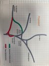
There exist plans for a large-scale remodelling of the Trent Jns/Sheet Stores area and so a section has been omitted whilst further work is carried out.
I've seen different suggestions to that, and recent changes to HS2 have probably not helped, but something along that line yes. There will be a desire to increase the line speed through Trent East Junction for London-Nottingham traffic and through Sheet Stores Junction for London-Derby Traffic.
I've seen different suggestions to that, and recent changes to HS2 have probably not helped, but something along that line yes. There will be a desire to increase the line speed through Trent East Junction for London-Nottingham traffic and through Sheet Stores Junction for London-Derby Traffic.
That plan was originally in Network Rail's Route Utilisation Study, and it was claimed that it would be needed by 2043 even with HS2 as originally proposed; I think it was more to do with capacity than speed - from memory, isn't there a bit as low as 10mph for trains passing over the up at Sheet Stores, and wasn't this necessary to maximise the speed for trains going between Long Eaton and East Midlands Parkway?
== Doublepost prevention - post automatically merged: ==
Looking again, I guess it depends what's meant by Trent Junction; certainly, there's no mention at all of Trent South and Trent East to Sheet Stores, so they're definitely not listed, and if Trent Junction to Nottingham means from the East one, then no side of the triangle is listed as to be wired
That plan was originally in Network Rail's Route Utilisation Study, and it was claimed that it would be needed by 2043 even with HS2 as originally proposed; I think it was more to do with capacity than speed - from memory, isn't there a bit as low as 10mph for trains passing over the up at Sheet Stores, and wasn't this necessary to maximise the speed for trains going between Long Eaton and East Midlands Parkway?
That plan was originally in Network Rail's Route Utilisation Study, and it was claimed that it would be needed by 2043 even with HS2 as originally proposed; I think it was more to do with capacity than speed - from memory, isn't there a bit as low as 10mph for trains passing over the up at Sheet Stores, and wasn't this necessary to maximise the speed for trains going between Long Eaton and East Midlands Parkway?
Looking again, I guess it depends what's meant by Trent Junction; certainly, there's no mention at all of Trent South and Trent East to Sheet Stores, so they're definitely not listed, and if Trent Junction to Nottingham means from the East one, then no side of the triangle is listed as to be wired
I've seen different suggestions to that, and recent changes to HS2 have probably not helped, but something along that line yes. There will be a desire to increase the line speed through Trent East Junction for London-Nottingham traffic and through Sheet Stores Junction for London-Derby Traffic.
Yes, anything going from Nottingham towards Derby has to negotiate a fixed diamond on a negative cant with a 10mph restriction. I don't see the speed of trains between Long Eaton and East Midlands Parkway as the issue here, as it's also constrained by Trent South and by most or all trains probably stopping at Parkway in future anyway. The main benefit of increasing that 10mph would be to reduce the time during which any train taking that route blocks the main line in both directions. However, it's hard to see how it would be possible without drastic changes to the railway alignments in the area, even if the curve towards Castle Donington was expensively replaced. Housing prevents any significant change to the line towards Long Eaton station, and now extends right up to the railway boundary on the north side of the curve.
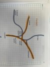
Trent South and East, Sheet Stores and sometimes the other junctions nearby are collectively and informally known as the "Trent Junctions" or similar terminology.
Yes, anything going from Nottingham towards Derby has to negotiate a fixed diamond on a negative cant with a 10mph restriction. I don't see the speed of trains between Long Eaton and East Midlands Parkway as the issue here, as it's also constrained by Trent South and by most or all trains probably stopping at Parkway in future anyway. The main benefit of increasing that 10mph would be to reduce the time during which any train taking that route blocks the main line in both directions. However, it's hard to see how it would be possible without drastic changes to the railway alignments in the area, even if the curve towards Castle Donington was expensively replaced. Housing prevents any significant change to the line towards Long Eaton station, and now extends right up to the railway boundary on the north side of the curve.
Trent South and East, Sheet Stores and sometimes the other junctions nearby are collectively and informally known as the "Trent Junctions" or similar terminology.
Unless removing the western Sheet Stores Jnc allows the line from Trent South to be moved slightly South / West with the eastern Sheet Stores Jnc then remodeled with longer cross overs
Yes, anything going from Nottingham towards Derby has to negotiate a fixed diamond on a negative cant with a 10mph restriction. I don't see the speed of trains between Long Eaton and East Midlands Parkway as the issue here, as it's also constrained by Trent South and by most or all trains probably stopping at Parkway in future anyway. The main benefit of increasing that 10mph would be to reduce the time during which any train taking that route blocks the main line in both directions. However, it's hard to see how it would be possible without drastic changes to the railway alignments in the area, even if the curve towards Castle Donington was expensively replaced. Housing prevents any significant change to the line towards Long Eaton station, and now extends right up to the railway boundary on the north side of the curve.
Trent South and East, Sheet Stores and sometimes the other junctions nearby are collectively and informally known as the "Trent Junctions" or similar terminology.
Looking at Google Maps, the civils interventions required to produce that map like-for-like would be complex and eyewateringly expensive. Mind you, with Ratcliffe PS due to close, a small slice of the land there could be used to build a flying junction (presumably from the Slows) to get west over the MML, the Soar, and probably Lockington Marshes too (which might make it a bit tricker to do).
I had a look around Kettering to Desborough today. There are a few more cantilevers up around Rushton and the worksite still has about 40 masts/piles and cantilevers ready to be installed. It does seem to be winding down though. There are still no piles/masts to be seen through Desborough yet.
Wonder why they're going on about the route through Chadd Sdgs? The section between Spondon Jn and Derby North Jn closed as a through route in 1969. Much has been built on. Has someone been using an old database somewhere?
Looking at Google Maps, the civils interventions required to produce that map like-for-like would be complex and eyewateringly expensive. Mind you, with Ratcliffe PS due to close, a small slice of the land there could be used to build a flying junction (presumably from the Slows) to get west over the MML, the Soar, and probably Lockington Marshes too (which might make it a bit tricker to do).
Network Rail gave an indicative cost of between £175m and £375m; the price level isn't quoted, but the East Midlands Route Study was published in March 2016
The Route Study describes the new line as splitting as it approaches EMD (from Stenson) "to create a single connection-point via a grade separated junction (to the north) and a single connection point at grade to the south"
The area has changed a lot since March 2016; East Midlands Gateway has been built, the A453 has been made into a dual carriageway and is now named Remembrance Way, and there have been major roadworks altering the connection between the A50 and the M1 - I'm pretty sure the southbound connection at Junction 24A didn't exist back then.
For those not familiar with the area, the Sheet Stores - Trent East curve is "new". When the Midland Counties built the triangular junction which connected the Derby - Leicester - Nottingham lines together, the north side followed the alignment of what is now Fields Farm Road; and when the Midland built the line up the Erewash Valley, that also had a triangular junction at its south end and as it started south of the point where the lines from Derby/Leicester joined to head towards Nottingham, it crossed the one from Derby on a flat crossing. Then Trent station was built, together with the present curve from Trent East to Sheet Stores (which takes its name from it being the location of the MR's works for making wagon sheets - a lot of it still stands north of the MML and east of the bridge over the Erewash Canal); finally, the original north side of the triangle was cut back and a sharp curve built to connect it to the north end of Trent station - this meant that some trains from Trent to Derby left at the south end and went via the present curve to Sheet Stores, others at the north end, round the sharp curve and then over the original alignment to a junction just east of Long Eaton station (which was called Sawley Junction until the original Long Eaton station on the Erewash Valley line closed in the late 1960s).
The area north of the Trent East - Sheet Stores curve and south of the original alignment is now built on, and east of the Trent South - Trent East (and on towards Nottingham) has been heavily quarried for sand and gravel; a lot of these have been flooded, and some form the Attenborough nature reserve. There's also a flooded quarry south of the Derby line just after passing under the M1 at Long Eaton.
Therefore, the scope for doing "something" to ease curves, etc, is very restricted, and I guess that ground conditions - a lot of sand and gravel - will present challenges for electrification teams when "planting" structures between the Red Hill Tunnels (just north of EMD), at least Beeston towards Nottingham, and Draycott towards Derby
== Doublepost prevention - post automatically merged: ==
Wonder why they're going on about the route through Chadd Sdgs? The section between Spondon Jn and Derby North Jn closed as a through route in 1969. Much has been built on. Has someone been using an old database somewhere?
Seeing Chadd Sdgs in RS4 didn't surprise me as it is used to get trains between Etches Park and Derby station, but it did in RS6 - I would have thought that the latter should have been from the junction with the Chadd curve to Toadmoor Tunnel
Seeing Chadd Sdgs in RS4 didn't surprise me as it is used to get trains between Etches Park and Derby station, but it did in RS6 - I would have thought that the latter should have been from the junction with the Chadd curve to Toadmoor Tunnel
There's a whole thread on the options for tracks layouts around the Trent triangle after the HS2 stump is built. It would be crazy to install OHLE in this area before the detailed design work for the HS2 connection.
The IRP talked about the need to grade-separate HS2 to NOT flows from the NOT to DBY traffic, but i don't see that there's enough space around the triangle to do this, without severing the low-level route to Toton.
My copy of the May issue of Modern Railways has arrived. There's an MML item on page 12
.....
The next section being developed, known as Section 2, is Wigston South Junction to Syston Junction, so in other words the Leicester area, which is apparently now being taken forward as a standalone electrification scheme, neither integrated with nor waiting for a capacity improvement scheme. "Work is ongoing to obtain approval to go into design for Section 2."
My copy of the May issue of Modern Railways has arrived. There's an MML item on page 12
.....
The next section being developed, known as Section 2, is Wigston South Junction to Syston Junction, so in other words the Leicester area, which is apparently now being taken forward as a standalone electrification scheme, neither integrated with nor waiting for a capacity improvement scheme. "Work is ongoing to obtain approval to go into design for Section 2."
This seems to be the complete opposite approach by NR to the (non) electrification of Oxford. There, electrification was curtailed awaiting the rebuilding of Oxford station. Now it appears to be to push on regardless.
This seems to be the complete opposite approach by NR to the (non) electrification of Oxford. There, electrification was curtailed awaiting the rebuilding of Oxford station. Now it appears to be to push on regardless.
It wasn't rebuilding the station that was blocking, but resignalling the area and some remodelling of the track. That has now been done so electrification can proceed.
Wonder why they're going on about the route through Chadd Sdgs? The section between Spondon Jn and Derby North Jn closed as a through route in 1969. Much has been built on. Has someone been using an old database somewhere?
Since the remodelling a few years ago trains coming out of Etches Park to head south now have to go into what is left of Chaddesden Sidings before reversing back through Derby station towards Spondon or Peartree. So that would need to be electified to allow electric trains in and out of the the depot. I would guess RS4 includes that, Derby station and Etches Park itself. RS6 is then from that point north
The electrical work to improve the infrastructure certainly is. I'm not entirely sure if any mechanical work to re-grade the Fast lines' OLE has begun yet though - while a few new structures have been sporadically installed along the route, all of these are replacements for failing structures IIRC.
The electrical work to improve the infrastructure certainly is. I'm not entirely sure if any mechanical work to re-grade the Fast lines' OLE has begun yet though - while a few new structures have been sporadically installed along the route, all of these are replacements for failing structures IIRC.
The electrical work to improve the infrastructure certainly is. I'm not entirely sure if any mechanical work to re-grade the Fast lines' OLE has begun yet though - while a few new structures have been sporadically installed along the route, all of these are replacements for failing structures IIRC.
Saw those yesterday myself - based on the presence of anchor masts with Tensorex sandwiching them, those two will be for an overlap.
There's still 2 TTC masts missing between Station Rd (U/B 45) and Bridle Rd (O/B 44), and 3 structures missing between O/B 44 & F/B 43; one of which is an MPA portal.
Again, Napsbury will only be a sectioning site for OLE isolation purposes (like most of the MML locations where switchgear is visible). In normal operation the Midland Main Line is only fed at Borehamwood and Chalton (Grahame Park still has its 132kV DNO connection as a backup, I assume).
My understanding is that KO1a modification works on the original "BedPan"* stretch are split into three distinct groups - resectioning (which includes a northward shift of the neutral section between the Borehamwood / Chalton feeds), conversion of feeding system (replacing return conductors / booster transformers with return screening conductors / aerial earth wires means reduced power transmission losses) and mechanical OLE mods (regrading of fast line OLE and registration arm adjustments). It's the third group that'll remove the 100mph limit on electric rolling stock south of Bedford.
[* Whoever came up with that way back when must have had quite the dry sense of humour]