• Our new ticketing site is now live! Using either this or the original site (both powered by TrainSplit) helps support the running of the forum with every ticket purchase! Find out more and ask any questions/give us feedback in this thread!

London Overground map doesn't show Zones

Status
Not open for further replies.

ert47

Member
Joined
28 Feb 2010
Messages
688
[thnx mods :)]

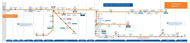
The other day when travelling on the LO, I had a thought as to why the Network map didnt have zones indicated on it as seen on London Underground maps.

With the orbital system in place, I can see it being one legible nightmare trying to mark the zones in especially with stations such as Euston and Shoreditch High Street being in zone 1 and Watford Junction located beyond Zone 8.

Just out of curiosity, has anyone tried to zone the LO map? (ignoring London Connection/Tube maps)
 

Attachments

  • DSC_0025.jpg
    DSC_0025.jpg
    102.7 KB · Views: 172
Last edited:
Sponsor Post - registered members do not see these adverts; click here to register, or click here to log in
R

RailUK Forums

465fan

On Moderation
Joined
26 Jul 2009
Messages
503
Location
Bexley
[thnx mods :)]

The other day when travelling on the LO, I had a thought as to why the Network map didnt have zones indicated on it as seen on London Underground maps.

With the orbital system in place, I can see it being one legible nightmare trying to mark the zones in especially with stations such as Euston and Shoreditch High Street being in zone 1 and Watford Junction located beyond Zone 8.

Just out of curiosity, has anyone tried to zone the LO map? (ignoring London Connection/Tube maps)


I think the layout of that map precludes sensible or legible zoning.

I would however suggest that they install (if they don't have them anyway) a London Connections map with Zones to their trains, so people can understand where the Zones are. I would also put up notices explaining the way the Pink "validators" work.
 

Class377/5

Established Member
Joined
19 Jun 2010
Messages
5,594
Yes I have. This was an early version.


Overground Line Map v2 by Sparkyscrum, on Flickr

How've doesn't appear I've put the full LO one on my Flickr but had it sorted with the completed loop but cheated a tad with zone 1. Will have a look later to see if I can post.
 

greatkingrat

Established Member
Joined
20 Jan 2011
Messages
3,293
The problem with that is some passengers might think the NLL passes through zone 1 and their ticket isn't valid.
 

Clip

Established Member
Joined
28 Jun 2010
Messages
10,821
Its a tough one to sort out but they seem to be able to manage the complexity of it on the DLR to some extent with thin grey lines separating all the southern/eastern zones so its not impossible.
 

bronzeonion

Member
Joined
1 Apr 2009
Messages
673
Location
West London


I think the layout of that map precludes sensible or legible zoning.

I would however suggest that they install (if they don't have them anyway) a London Connections map with Zones to their trains, so people can understand where the Zones are. I would also put up notices explaining the way the Pink "validators" work.


The trains carry the standard Tube map (just like the little fold up ones but bigger and stuck to the wall) rather than a London Connections map already.

I can agree on the whole pink reader business, one of the few things TfL did not promote to such an extent!
 

ert47

Member
Joined
28 Feb 2010
Messages
688
bronzeonion:1332778 said:
The trains carry the standard Tube map (just like the little fold up ones but bigger and stuck to the wall) rather than a London Connections map already.

I can agree on the whole pink reader business, one of the few things TfL did not promote to such an extent!

Would have thought the connections map would have made more sense due to the shared track with NR in parts.

Otherwise when it comes to zonal sign posting, could they put stickers on station signs with the zone number much like other TOCs have done?
 

leytongabriel

Member
Joined
27 Jan 2013
Messages
639
Its also been printed in special fading ink so that at outdoor stations (like most of them)
the orangey LO lines become almost invisible where exposed to sunlight. Good thinking guys.
 

NSE

Established Member
Joined
3 Mar 2010
Messages
1,919
Using that map from Flickr, I personally would just put a small circle around Euston and one round Shoreditch.
 

Monty

Established Member
Joined
12 Jun 2012
Messages
2,370
Its also been printed in special fading ink so that at outdoor stations (like most of them)
the orangey LO lines become almost invisible where exposed to sunlight. Good thinking guys.

I don't think that's a problem that is exclusive to LOROL really, most posters displayed outdoors for anything length of time appear to suffer from fading from exposure to the sun.
 

leytongabriel

Member
Joined
27 Jan 2013
Messages
639
I don't think that's a problem that is exclusive to LOROL really, most posters displayed outdoors for anything length of time appear to suffer from fading from exposure to the sun.

Sure but the ironic thing I was trying to point out is that on the LO maps its the red/orange colours that fade the fastest so the rest of the map is still legible but you can't follow the the LO routes at all.
 

ert47

Member
Joined
28 Feb 2010
Messages
688
Sure but the ironic thing I was trying to point out is that on the LO maps its the red/orange colours that fade the fastest so the rest of the map is still legible but you can't follow the the LO routes at all.

Its worse when you cant even see what station you're at because of the yellow lights in the station that make Orange and White appear to be the same colour...
 

colchesterken

Member
Joined
12 Oct 2010
Messages
768
C2C have a super clear diagram in each coach showing where you can go with the zones

dont see why L O could not do the same thing
 

ert47

Member
Joined
28 Feb 2010
Messages
688
C2C have a super clear diagram in each coach showing where you can go with the zones

dont see why L O could not do the same thing

The problem is the shape of the route - the C2C route is fairly linear in comparison so the zones only go from 1-6. With LO, there is an orbital network with both Euston and Shoreditch High Street in Zone 1 and then theres Watford Junction, Barking, West Croydon and Richmond in opposite directions
 

Waddon

Member
Joined
15 Sep 2009
Messages
469
The Overground maps could definitely do with a redesign, especially the on-train ones... it seems like every time a new bit of alignment was added, it was just squeezed in wherever it would fit on the map, resulting in all the east and south London bits being crammed effectively into one corner.

Similar thing with the maps on Southern trains, which due to all the folds and twists give the impression that somewhere like Southampton Airport is nearer to Horsham than Battersea Park is to Victoria...

Because the classic underground map is so highly regarded, the designers seem reluctant to tinker with the format, but it just isn't suitable for all routes, they should have an open design competition to see what people can come up with.
 
Status
Not open for further replies.

Top