
• Our new ticketing site is now live! Using either this or the original site (both powered by TrainSplit) helps support the running of the forum with every ticket purchase! Find out more and ask any questions/give us feedback in this thread!

Inaccurate route diagram

Status
Not open for further replies.

hermit

Member
Joined
23 Jul 2019
Messages
443
Location
Isle of Wight
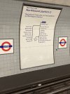
Waiting for a northbound Northern Line train at Euston (Bank branch) I noticed that the route display on the opposite wall has the two branches of the line in the wrong geographical relation to each other. In reality, trains to Edgware turn left at Camden Town, not right as shown here.
Is this unique to Euston, and can anyone think of a reason for it?
 

Attachments

  • 8998E3AE-C9FA-48E5-B310-9B20C176BC5F.jpeg
    8998E3AE-C9FA-48E5-B310-9B20C176BC5F.jpeg
    2.4 MB · Views: 254
Sponsor Post - registered members do not see these adverts; click here to register, or click here to log in
R

RailUK Forums

ComUtoR

Established Member
Joined
13 Dec 2013
Messages
9,562
Location
UK
Kinda depends how you are reading it. If you read it top to bottom it's a left turn. It's clearly branching left at Camden
 

Mojo

Forum Staff
Staff Member
Administrator
Joined
7 Aug 2005
Messages
21,172
Location
0035
Kinda depends how you are reading it. If you read it top to bottom it's a left turn. It's clearly branching left at Camden
Yes I’d say it’s the right way round.
 

htafc

Member
Joined
30 Dec 2021
Messages
363
Location
West Yorkshire
Perhaps it's to do with the fact that, on a full tube map (the 'correct' way round), Edgware is on the left and High Barnet on the right.
 

stuu

Established Member
Joined
2 Sep 2011
Messages
3,763
Edgware is on the left/west on the diagram and in reality. The Mill Hill branch is the same. Seems fine to me
 

swt_passenger

Veteran Member
Joined
7 Apr 2010
Messages
34,243
If I was starting with a clean slate, northbound line diagrams would all have the origin at the bottom, and the southbounds would have it at the top. :D I’m still undecided about east and west though…:s
 

alf

On Moderation
Joined
1 Mar 2021
Messages
422
Location
Bournemouth
Edgware is on the left/west on the diagram and in reality. The Mill Hill branch is the same. Seems fine to me
If left is west & right is east then why are Edgware, High Barnet & Mill Hill SOUTH of Camden Town & Euston in the diagram ?

Something wrong surely....definitely not fine!

Interesting conundrum.
 

pdeaves

Established Member
Joined
14 Sep 2014
Messages
5,932
Location
Gateway to the South West
It's a diagram to show what order things are connected. It is not intended to be geographically accurate (for a start, stations would have to be different distances apart). Does it really matter if it is or is not 'correct' from that perspective?
 

Taunton

Veteran Member
Joined
1 Aug 2013
Messages
12,232
Well, I'm used to maps and diagrams, but have to look twice at this sort of representation.

For me, north is always at the top, whether a map or diagrammatic. One would have hoped that the NORTHERN Line, of all operations, might get this. I'm not one of those who, when travelling south, has to turn the map upside-down. And it certainly wouldn't be possible with this diagram.

I know the Underground does try. On lines where trains cannot be turned I always admired how the line diagrams on opposite sides of the car were mirror images of one another, so the end points pointed to the correct end. But branches were always shown on the correct relative side. I think in this wall diagram they would have been better with a version like the line diagrams, with horizontal landscape format, pointing the way the trains go.
 

30907

Veteran Member
Joined
30 Sep 2012
Messages
21,935
Location
Airedale
Well, I'm used to maps and diagrams, but have to look twice at this sort of representation.

For me, north is always at the top, whether a map or diagrammatic.
OTOH, it is conventional to read a list downwards, and AFAIK this is standard LUL/LT /LPTB practice. And indeed NR, eg at St Pancras TL.

TBH I don't think it matters in this context which branch is which - whereas on a route plan, or the tube map, it does!
 

zwk500

Veteran Member
Joined
20 Jan 2020
Messages
18,453
Location
Northampton
It's slightly mad - although the Mill Hill branch is also shown consistently 'mirrored'.

From a personal point of view, as long as the correct stations are on the same branch, exactly which way round it is doesn't matter, as I don't need to tell the train which way to go at Camden Town. But I do understand how the diagram can feel jarring to people.
 

Mojo

Forum Staff
Staff Member
Administrator
Joined
7 Aug 2005
Messages
21,172
Location
0035
If left is west & right is east then why are Edgware, High Barnet & Mill Hill SOUTH of Camden Town & Euston in the diagram ?

Something wrong surely....definitely not fine!

Interesting conundrum.
It is standard practice, and quite sensible for readability, for diagrams only showing one direction to have the current station at the top and then all possible destinations from it underneath.
 

Taunton

Veteran Member
Joined
1 Aug 2013
Messages
12,232
It is standard practice, and quite sensible for readability, for diagrams only showing one direction to have the current station at the top and then all possible destinations from it underneath.
But it does mean that the diagram is the opposite way round to the standard Underground map which will be on the opposite wall, if you first look at one, then the other, it must be confusing for the relative orientation.
 

zero

Established Member
Joined
3 Apr 2011
Messages
1,593
Regarding the maps on tube platforms as in the OP, they really should be horizontal in the same direction as the trains run - as in the Argyle St diagram (but that should have Argyle St itself a bit more prominent).

The maps in tube trains themselves should also be in the same direction as the running direction, i.e. the maps on opposite sides of the train should be in reverse to each other. Though this may not work on the Circle/H&C where I believe sometimes trains switch directions to even out wear on the wheels?

I feel that in the Argyle St diagram Milngavie and Maryhill etc should be below the main horizontal line, but could be persuaded either way.
 

Dstock7080

Established Member
Joined
17 Feb 2010
Messages
3,513
Location
West London
The maps in tube trains themselves should also be in the same direction as the running direction, i.e. the maps on opposite sides of the train should be in reverse to each other. Though this may not work on the Circle/H&C where I believe sometimes trains switch directions to even out wear on the wheels?
Unfortunately no longer possible on Central Circle District H&C Metropolitan Northern Piccadilly as trains are regularly turned.
 

317 forever

Established Member
Joined
21 Aug 2010
Messages
3,260
Location
North West
Regarding the maps on tube platforms as in the OP, they really should be horizontal in the same direction as the trains run - as in the Argyle St diagram (but that should have Argyle St itself a bit more prominent).

The maps in tube trains themselves should also be in the same direction as the running direction, i.e. the maps on opposite sides of the train should be in reverse to each other. Though this may not work on the Circle/H&C where I believe sometimes trains switch directions to even out wear on the wheels?

I feel that in the Argyle St diagram Milngavie and Maryhill etc should be below the main horizontal line, but could be persuaded either way.
I agree. It is odd having such diagrams upside down in the first place.
 

Hadders

Veteran Member
Associate Staff
Senior Fares Advisor
Joined
27 Apr 2011
Messages
18,111
Unfortunately no longer possible on Central Circle District H&C Metropolitan Northern Piccadilly as trains are regularly turned.
It doies frustrate me that they can't even get mirrored diagrams on the Victoria Line.
 

Dstock7080

Established Member
Joined
17 Feb 2010
Messages
3,513
Location
West London
It doies frustrate me that they can't even get mirrored diagrams on the Victoria Line.
in the mid-90s there was a policy of handed maps on Bakerloo District (D Stock) Jubilee Victoria W&City but the extra costs involved in printing two maps finished it
 
Last edited:

AlbertBeale

Established Member
Joined
16 Jun 2019
Messages
3,188
Location
London
in the mid-90s there was a policy of handed maps on Bakerloo District (D Stock) Jubilee Victoria W&City but the extra costs involved in printing two maps finished it

I don't think I'd noticed that the lines with trains that never get turned in service had stopped having diagrams which always matched the direction of travel, on both sides... I guess because I'd rarely have any reason to use the line diagrams!

Perhaps, in some ways, having these lines standardised to match the convention used for all the others (ie broadly north-south lines have N-S running L-R, and lines which are overall west-east have W-E running L-R) is less confusing for visitors. Having some non-standard (even if otherwise logical) layouts might puzzle some people.
 

miklcct

Established Member
Joined
2 May 2021
Messages
5,017
Location
Cricklewood
OTOH, it is conventional to read a list downwards, and AFAIK this is standard LUL/LT /LPTB practice. And indeed NR, eg at St Pancras TL.

TBH I don't think it matters in this context which branch is which - whereas on a route plan, or the tube map, it does!
The Hong Kong MTR practice is the reverse - the list is read upwards, with the destination on top.
It doies frustrate me that they can't even get mirrored diagrams on the Victoria Line.
Mirrored in-train diagrams are also standard in Hong Kong. All heavy rail trains there can't be turned with each end pointing to a fixed direction, hardwired into the signalling system.
 

Recessio

Established Member
Joined
4 Aug 2019
Messages
1,496
Location
London
The Victoria line in-car diagrams are wrong imo. The line runs from Brixton in the South West to Walthamstow in the North East, but the map inside runs from right to left - East to West, the other way around.
 

Mojo

Forum Staff
Staff Member
Administrator
Joined
7 Aug 2005
Messages
21,172
Location
0035
The Victoria line in-car diagrams are wrong imo. The line runs from Brixton in the South West to Walthamstow in the North East, but the map inside runs from right to left - East to West, the other way around.
The Victoria line is Southbound and Northbound not Eastbound and Westbound. Accordingly the north end of the line is on the left, in line with the present convention to have the north end on the left.
 
Status
Not open for further replies.

Top