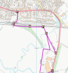
Potentially a bit of a niche query, but I am very curious if anyone happens to know anything about the history of Headcorn station in relation to the footbridge access from the south side of the railway? My partner recently ended up completely stranded in the area and trying to get to the station on foot approaching from the south - there is no safe walking route along the A274 Biddenden Road, so she attempted to follow a path marked on Google Maps, via the nearby Bletchenden Road, through the fields adjacent to the nearby industrial site. While you can, eventually, reach the footbridge this way, it apparently involved hopping several locked gates, walking straight through fields of crops and livestock, and scrabbling up an embankment! Surely this is not an actual public right of way - OpenStreetMap for example just shows a path to nowhere in the nearby trees.
Is there any story or history behind this bizarre station access? Obviously it came in handy in this case (though it doesn't sound like something to be repeating any time soon), but I can't help but think she must have been the only person to use that particular entrance to the station in a very long time!

Is there any story or history behind this bizarre station access? Obviously it came in handy in this case (though it doesn't sound like something to be repeating any time soon), but I can't help but think she must have been the only person to use that particular entrance to the station in a very long time!