Our new ticketing site is now live! Using either this or the original site (both powered by TrainSplit) helps support the running of the forum with every ticket purchase! Find out more and ask any questions/give us feedback in this thread!
Recently got talking to a Stoke/Newcastle local about HS2 for a research project I'm doing. He mentioned in passing that in the Etruria Valley there is lots of disused existing infrastructure which I made a note of to visit.
Coming home to look into it, the 'Etruria Valley' seems to mostly refer to a link road currently being built more than it does a geographical area for me to search. I was hoping that someone on this forum might know where this gentleman might have been referring to?
Recently got talking to a Stoke/Newcastle local about HS2 for a research project I'm doing. He mentioned in passing that in the Etruria Valley there is lots of disused existing infrastructure which I made a note of to visit.
Coming home to look into it, the 'Etruria Valley' seems to mostly refer to a link road currently being built more than it does a geographical area for me to search. I was hoping that someone on this forum might know where this gentleman might have been referring to?
So, where exactly are we talking here by 'Etruria Valley'? Land alongside the main line between Stoke-on-Trent and, say, Longport stations? So, maybe Granville Sidings, Cockshute Sidings, the Cliffe Vale terminal? Elsewhere?
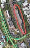
Etruria Valley is the "posh" name the local council have given to the regenerated former Shelton Bar steelworks. Basically the area North of the former Etruria station and south of Longport, on the East side of the railway line. I expect the sidings in question are those to the immediate north of the former Etruria station (where the A53 road bridge crosses the railway), which once had a link into the steelworks itself. Sidings circled in red in the screenshot below.
Etruria Valley is the "posh" name the local council have given to the regenerated former Shelton Bar steelworks. Basically the area North of the former Etruria station and south of Longport, on the East side of the railway line. I expect the sidings in question are those to the immediate north of the former Etruria station (where the A53 road bridge crosses the railway), which once had a link into the steelworks itself. Sidings circled in red in the screenshot below.
Seem to recall those sidings were used when they upgraded the WCML Stoke area. Maybe the odd P Way train in there since. Of course, once upon a time, wasn't there a colliery on the opposite side of the line?
Seem to recall those sidings were used when they upgraded the WCML Stoke area. Maybe the odd P Way train in there since. Of course, once upon a time, wasn't there a colliery on the opposite side of the line?
Attached is my plan of the Stoke area from around 1979; I note on it that the goods lines avoiding Stoke station were removed in 1985 and I used them once prior to then. Grange Junction and Bradwell Sidings were block posts - and Longport - the first of which was responsible for the various goods lines still there at the time (although Stoke box went north of Etruria).
Attached is my plan of the Stoke area from around 1979; I note on it that the goods lines avoiding Stoke station were removed in 1985 and I used them once prior to then. Grange Junction and Bradwell Sidings were block posts - and Longport - the first of which was responsible for the various goods lines still there at the time (although Stoke box went north of Etruria).
Lots, most of the WCML, this was before Quail/Trackmaps so I drew my own, often with help from signalling notices - the Stoke one from the original SE signalling notice but Longport/Bradwell Sidings from observation which is why there’s less detail. I lived in Bollington and primarily used Macclesfield until 1980, when I went to university and my hand-drawn stuff mainly stopped then although I occasionally annotated the ones I had in later years.
In Bollington and prior to that many were pinned on my bedroom wall, my parents put up with it!
Too many to post here but if an area of interest is covered I don’t mind scanning and uploading a small number.
Search for “diagram” (or something similar) posted by me and you can see most of the ones I’ve previously posted.
Seem to recall those sidings were used when they upgraded the WCML Stoke area. Maybe the odd P Way train in there since. Of course, once upon a time, wasn't there a colliery on the opposite side of the line?
Attached is my plan of the Stoke area from around 1979; I note on it that the goods lines avoiding Stoke station were removed in 1985 and I used them once prior to then. Grange Junction and Bradwell Sidings were block posts - and Longport - the first of which was responsible for the various goods lines still there at the time (although Stoke box went north of Etruria).
The siding at SE82 was 'fish dock'. Latterly used for stabling locos for the steelworks, before they got moved to Bescot, since then filled in and used as a new taxi rank to replace taxis stopping outside the front of the station. Yes, they are currently remodelling that bit of road outside the station, yet again!
== Doublepost prevention - post automatically merged: ==
From Kidsgrove:
On the west side is Chatterley Valley which was the opencast coal loading point (opencast disposal point the proper name). Closed some time ago and demolished more recently. I recall that HM The Queen spent the night there in 1999 (on the royal train not dossing down as an urban explorer). The land is being regraded into plateaux suitable for development, yes probably more warehouses and not rail-served as the land levels have been raised. The track and connections remain in place. On the same side a bit to the south is the former Carless oil terminal, now in use as a scrapyard and not rail served but I think the track is mostly in place - but hopefully disconnected from the live line.
On the east side is the JCB warehouse, about to be closed, so if anyone needs a vary large, eco-friendly warehouse close to the WCML, phone Lord Bamford soonest.
South of that on the east side is the former Esso oil terminal, now in use by Land Recovery and definitely rail served.
Adjacent to Longport station there is EMD on the east side (where the 69's are rebuilt) and on the west side some sidings, most recently used in connection with Marcoft wagon works. The sidings were cleared of trees a few years ago but now it is a silver birch forest once again.
North of Etruria Station (that was) are Granville sidings on the east side (where the yellow plant sometimes lives).
South of that, on the east side is Cockshute Sidings (where the redundant EMU coaches and now also some coal hoppers live).
South of that, on the east side just before Stoke signal box are sidings where white track plant often lives.
Opposite that, on the west side, is the Cliffe Vale china clay terminal.
The siding at SE82 was 'fish dock'. Latterly used for stabling locos for the steelworks, before they got moved to Bescot, since then filled in and used as a new taxi rank to replace taxis stopping outside the front of the station. Yes, they are currently remodelling that bit of road outside the station, yet again!
Interesting, thank you.
My observation is that the up main lasted into the Pendolino era, I used it on the first 07:00 Manchester-London service (only call was Stockport) but getting rid of it removed the approach release on SE64 which made sense.
I have good friends in Stoke and see things going on around the station these days, it seems like an improvement although I don’t really know what it used to be like beyond the station platforms.
Interesting, thank you.
My observation is that the up main lasted into the Pendolino era, I used it on the first 07:00 Manchester-London service (only call was Stockport) but getting rid of it removed the approach release on SE64 which made sense.
I have good friends in Stoke and see things going on around the station these days, it seems like an improvement although I don’t really know what it used to be like beyond the station platforms.
One of the comments about the WCML works and the big Stoke-on-Trent blockade was that the existing layout was simply replaced, keeping all the parallel lines, crossovers etc from a previous era.
One of the comments about the WCML works and the big Stoke-on-Trent blockade was that the existing layout was simply replaced, keeping all the parallel lines, crossovers etc from a previous era.
On the east side is the JCB warehouse, about to be closed, so if anyone needs a vary large, eco-friendly warehouse close to the WCML, phone Lord Bamford soonest.
On the same side a bit to the south is the former Carless oil terminal, now in use as a scrapyard and not rail served but I think the track is mostly in place - but hopefully disconnected from the live line.
At one time, the line between Kidsgrove and Longport was on a different alignment, through Harecastle Tunnel. The route went behind the current JCB warehouse.
== Doublepost prevention - post automatically merged: ==
Many years ago, I remember there being a meeting at Stoke railway station. They were looking at how to extend the platforms to accommodate 11 car Pendolinos. Take out the fast line, nothing used it . At that moment, the Pullman Pendolino went through about 07.35, followed by two test/RTC trains. Nothing eh?
We are aware of an issue with emails from the Forum to Microsoft-based email accounts (hotmail/outlook/live.com email addresses). This is being looked into currently, thanks for your patience meanwhile.