• Our new ticketing site is now live! Using either this or the original site (both powered by TrainSplit) helps support the running of the forum with every ticket purchase! Find out more and ask any questions/give us feedback in this thread!

Death's Line Coverage Map

Status
Not open for further replies.

Broken Viking

On Moderation
Joined
23 Oct 2006
Messages
1,666
Location
some place west of France
Hail all! <D
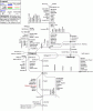
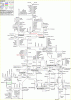
Whilst we're on the subject of new maps, one of my current projects is the creation of a stylised (And possibly easier to use) version of the current line coverage map (Seth Anderson-Crook's one) that we're all using. 8)

I've just spent the last few hours getting started with it, and I've managed to draft together the bits for Scotland and some of the North West.
Although it's more a brief overview of the network and probabally won't ever be expanded to Quail proportions, one of my intentions is to generate it so that it'll comfortably fit onto a single side of A4 and can be used for on-board route scratching. Whether I'll be able to cram it all into an A4 size layout though, I can't really say at the moment - But fingers crossed, I might be able to squeeze it in! :)

Anyhow...I've attached a WiP version below of how it is at the moment for everyone to have a look at. Comments and polite constructive critique are more than welcome! 8)

Farewell... <D
>> Death <<
 

Attachments

  • Deaths_UK_coverage_map_-_WiP_demo_-_Scotland_and_North_West.gif
    Deaths_UK_coverage_map_-_WiP_demo_-_Scotland_and_North_West.gif
    17.6 KB · Views: 78
Sponsor Post - registered members do not see these adverts; click here to register, or click here to log in
R

RailUK Forums

Techniquest

Veteran Member
Joined
19 Jun 2005
Messages
21,830
Location
Nowhere Heath
Crikey, not bad that at all! You'll have a helluva time making it fit onto a single A4 page, but you've done well with that so far!

As someone said of the projects James, Death and I are working on: "A new labour of love". So true...
 

will1337

Member
Joined
5 Feb 2008
Messages
613
Location
Laaandaaan
Noice styles Death but the one in this thread had the useful feature of each station having a line through the line so you can use the paint bucket.
 

Jordy

Established Member
Joined
9 Jun 2005
Messages
8,466
Location
WCML South
Agreed, I like the idea Death, but would it be possible to stop the flood fill tool filling large areas :)
 

will1337

Member
Joined
5 Feb 2008
Messages
613
Location
Laaandaaan
In paint.net and near certainly photoshop but I don't know for a fact you can turn down the sensitivity of the flood tool if it's flooding far too much, but obviously it'd still flood to the nearest junction.
 

Broken Viking

On Moderation
Joined
23 Oct 2006
Messages
1,666
Location
some place west of France
Hail again! <D
Crikey, not bad that at all! You'll have a helluva time making it fit onto a single A4 page, but you've done well with that so far!
Cheers for the compliment, Julian! Like I said the other day; If I'm going to be working on/assisting with a Quail, then I'd be(a)st get some Cartography practice in! 8)

Noice styles Death but the one in this thread had the useful feature of each station having a line through the line so you can use the paint bucket.
Agreed, I like the idea Death, but would it be possible to stop the flood fill tool filling large areas :)
That's something that I've been bearing in mind from the start, and - Although I'm not integrating it in yet as it makes changing the map a pain - I plan to release three different variants when (That is to say "if" :lol:) I get it finished:
  • Standard - The version from which I'm taking demos to post in this thread.
  • Quick fill - Each junction/crossover will have section lines drawn to allow paint-pot filling of whole sections of line at once, with only individual stations needing to be sectioned off by hand.
  • Detail fill - Each station, junction and crossover will have it's own dividing line that will allow best control over the fill tool...Although it will take more work to update each section as a result.
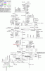
Anyhow...Even though I was planning to shut down the PC and run over to Tecos earlier today, I re-opened the file and did some more work on the Manchester/Liverpool and North Wales sections. I've attached the latest WiP version to this post as previously, too. :)

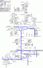
Addendum: Just had a bash at using it in a practical way, and put my coverage so far onto it..Again, copy attached by way of example. I hadn't realised before now that I'd been missing out so much of the North West in my previous travels! :shock:

Farewell, and enjoy! I may have to stave the work on this though as I really should have spent today planning my ALR! :shock:<D
>> Death <<
 

Attachments

  • Deaths UK coverage map - WiP demo - Scotland, North West and North Wales.gif
    Deaths UK coverage map - WiP demo - Scotland, North West and North Wales.gif
    22.7 KB · Views: 31
  • Deaths UK coverage map - WiP demo - Showing Deaths coverage of region.gif
    Deaths UK coverage map - WiP demo - Showing Deaths coverage of region.gif
    23.5 KB · Views: 35
Last edited by a moderator:

Techniquest

Veteran Member
Joined
19 Jun 2005
Messages
21,830
Location
Nowhere Heath
Hail Death!

Not bad at all matey, gotta ask though: What software are you using for that? Looks so much better than using Paint!

And you've not done much more of the North West than me really (I've not Blackpool South but have done Wigan NW to Liverpool for example), so I can't comment really!

Speaking of which, Wigan NW to Liverpool is currently missing on your map. Only other thing I've seen to point out thus far is that you have Wrexham down as Wrecham. Not major like, but thought I'd mention it.

Other than that, looking superb so far and I look forward to the full version in due course!
 

16CSVT2700

Established Member
Joined
4 Sep 2005
Messages
1,837
Location
Gdansk
Hail again! <D <snippage>
>> Death <<
Have done my coverage, and modified the Alloa bit as it joins onto the Fife Circle, see attachment
 

Attachments

  • Deaths UK coverage map - WiP demo - Scotland, North West and North Wales.gif
    Deaths UK coverage map - WiP demo - Scotland, North West and North Wales.gif
    23.7 KB · Views: 28

almark

Member
Joined
19 Nov 2008
Messages
746
Location
Wakefield
Oops thats got nothing!
 

Attachments

  • Deaths_UK_coverage_map_-_WiP_demo_-_Scotland_and_North_West.gif
    Deaths_UK_coverage_map_-_WiP_demo_-_Scotland_and_North_West.gif
    17.6 KB · Views: 13

almark

Member
Joined
19 Nov 2008
Messages
746
Location
Wakefield
here is mine,finally!


Cheers,
Mark
 

Attachments

  • Deaths UK coverage map - WiP demo - Scotland, North West and North Wales.gif
    Deaths UK coverage map - WiP demo - Scotland, North West and North Wales.gif
    24.4 KB · Views: 17

Broken Viking

On Moderation
Joined
23 Oct 2006
Messages
1,666
Location
some place west of France
Hail again! <D
Not bad at all matey, gotta ask though: What software are you using for that? Looks so much better than using Paint!
Believe it or not, Paint is what I've actually done it in! Bear in mind that I like the design of the stylised 80's maps quite a lot (None of this rounded and "smooth" corners crap ye get nowadays!) and that's the style that this map is based on. 8)

Also, having everything running in multiples of 45° angles - Aside from making it clearer and easier to follow - Also means that generating the map programmatically (Something that I might start working on at a future date) is much easier and less CPU intensive. :)

Speaking of which, Wigan NW to Liverpool is currently missing on your map. Only other thing I've seen to point out thus far is that you have Wrexham down as Wrecham. Not major like, but thought I'd mention it.
Cheers for mentioning about the Wigan > Liverpool line...I've got the map open now and I'll try and squeeze it in in a second. :)

The spelling of "Wrecsam" (Wrexham) is intentional, as common practice for me is to use place names in the local language if I know them, and only use the English equivalent if I don't. Other examples are Caergybi (Holyhead), Cyffordd Llandudno (Llandudno Jct.) and Llanrwst Gogledd (Llanrwst North). 8)

Other than that, looking superb so far and I look forward to the full version in due course!
Cheers! Looking at the comments so far (And the number of people already scratching coverage on it!) I'll have to get a move on and finish the rest as soon as I can! :D

The map is looking like it might be closer to A3 size than A4 once it's fully complete, but I'm thinking I might be able to make it a double-sided plan with Scotland and the North on one side (Portrait) and the south and West on the other (Landscape). :)

Have done my coverage, and modified the Alloa bit as it joins onto the Fife Circle, see attachment
Ahh...Cheers for that man! I wasn't aware of that freight line at all (Indeed, the only ones I know of are Sellafield BNFL and Didcot coal heap! :shock:) but I've added it onto the main one following thy example! 8)

Whilst on the subject of freight and heritage lines, I'm thinking that using distinctly different colours for "covered" and "to do" on each category of line might be wise, as the current ones are too close to each other. Compare the blank map with my coverage one (Specifically, Y Rheilffordd Ffestiniog, which I've covered) and there isn't much contrast between "done" and "not done". :|

here is mine,finally!
I'll have to get cracking on a demo version of the "Easy-fill" map too, I think! :lol::D
[Edit: Although I'm feeling too tired to expand the map tonight, I've just created a quick demo of the EasyFill version. See attached file. It may look very much the same as the standard, but have a play around with the paint pot tool to see EasyFill at work! 8)]

Very good effort although I am confused with the inclusion of Brockley Whins, Seaburn and East Boldon as they are now part of the Tyne & Wear Metro, whereas the the rest of the metro system is missing. Is this something you intend to add in? also its Almouth for Alnwick not Alness. Its still a very good resource which I have saved :D
[Deaths note: This confused me no end as I havn't even done the south Tyne area yet, until I realised that Spoony was referring to the OP's map! :D]
Actually, that's a damn good point: If we discuss my map here, we're going to completely fudge up and confuse the conversation relating to the Quail plan that this thread originally related to! :shock::|

If it's worthwhile and not going to be too much work, could a Mod possibly move the posts discussing my map into a new thread please? Apologies for the inconvenience in advance. :)

Farewell... <D
>> Death <<
 

Attachments

  • Deaths UK coverage map - WiP demo - Scotland, North West and North Wales - With EasyFill.gif
    Deaths UK coverage map - WiP demo - Scotland, North West and North Wales - With EasyFill.gif
    23 KB · Views: 19
Last edited by a moderator:

dan_atki

Established Member
Joined
1 Nov 2006
Messages
1,879
If it's worthwhile and not going to be too much work, could a Mod possibly move the posts discussing my map into a new thread please? Apologies for the inconvenience in advance. :)

Done :). Considerably easier than the ALR discussion anyways ;) I'll have to start charging for this service :razz:
 

Techniquest

Veteran Member
Joined
19 Jun 2005
Messages
21,830
Location
Nowhere Heath
Hail again! <D Believe it or not, Paint is what I've actually done it in! Bear in mind that I like the design of the stylised 80's maps quite a lot (None of this rounded and "smooth" corners crap ye get nowadays!) and that's the style that this map is based on. 8)

Really? Looked more like a professional program you were using to me! :shock:

Good choice on style, seen lots of maps like that and it must help a lot to fit stuff in busy areas.

Death said:
Also, having everything running in multiples of 45° angles - Aside from making it clearer and easier to follow - Also means that generating the map programmatically (Something that I might start working on at a future date) is much easier and less CPU intensive. :)

Good idea that, I must say! Much less labour intensive no doubt, and as I discovered in the small hours of Monday morning just gone it can be frustrating when something doesn't quite fit or the mouse moves just when you don't want it too!

Death said:
Cheers for mentioning about the Wigan > Liverpool line...I've got the map open now and I'll try and squeeze it in in a second. :)

The spelling of "Wrecsam" (Wrexham) is intentional, as common practice for me is to use place names in the local language if I know them, and only use the English equivalent if I don't. Other examples are Caergybi (Holyhead), Cyffordd Llandudno (Llandudno Jct.) and Llanrwst Gogledd (Llanrwst North). 8)

No problem with the Wigan bit, I only noticed it really because I covered most of it in January on The Mersey Mancunian!

Fair enough with the use of local names, I can't say I've seen it done on other maps before. One you might not know is the Welsh for Bridgend - Pen - y - Bont ar Ogwr (not to be confused with Penybont on the Heart of Wales!) and the Welsh for Swansea is Abertawe. Can give you other examples sometime if you wish!

Death said:
Cheers! Looking at the comments so far (And the number of people already scratching coverage on it!) I'll have to get a move on and finish the rest as soon as I can! :D

The map is looking like it might be closer to A3 size than A4 once it's fully complete, but I'm thinking I might be able to make it a double-sided plan with Scotland and the North on one side (Portrait) and the south and West on the other (Landscape). :)

No worries, since I started the UK Quail, which I'll do a seperate thread for, I know first-hand how much work it is!

I had a feeling it wouldn't fit on one side of A4, but that's a good way of getting around it there. :)

Death said:
Whilst on the subject of freight and heritage lines, I'm thinking that using distinctly different colours for "covered" and "to do" on each category of line might be wise, as the current ones are too close to each other. Compare the blank map with my coverage one (Specifically, Y Rheilffordd Ffestiniog, which I've covered) and there isn't much contrast between "done" and "not done". :|

I'll have to get cracking on a demo version of the "Easy-fill" map too, I think! :lol::D
[Edit: Although I'm feeling too tired to expand the map tonight, I've just created a quick demo of the EasyFill version. See attached file. It may look very much the same as the standard, but have a play around with the paint pot tool to see EasyFill at work! 8)]

Good idea with the different colours, although I'm not sure of any recommendations (the grey matter has been working overtime with advice on ALR'ing!)

Gonna have a look at the demo version you've attached, may reply later with my coverage done on it along with comments on the ease of use, etc.

Until later,

Julian, when it comes to HST froth, come to me :lol:
 

Techniquest

Veteran Member
Joined
19 Jun 2005
Messages
21,830
Location
Nowhere Heath
Wow, that only took a little over 5 minutes to do! :shock:

Two points to raise: Nothing major, but I had to add a gap between the Blackburn to Manchester line and the Copy Pit route, as I haven't done that bit but FloodFill went and coloured it in. No biggie like, but perhaps worth noting.

Bigger point was that the rest of the Oldham Loop from Rochdale through Oldham into Manchester Victoria is missing. I noticed it as I went to colour it in. Not a major route by any measure, but still worth adding.

My coverage on your map is here in an attachment. Blue lines are those covered, with the coloured station squares being stations I've visited:
 

Attachments

  • My_coverage_on_Death's_demo_map.GIF
    My_coverage_on_Death's_demo_map.GIF
    23.8 KB · Views: 12

Broken Viking

On Moderation
Joined
23 Oct 2006
Messages
1,666
Location
some place west of France
Hail again! <D
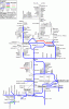
Just a quick update on my stylised design of the nework map, really. I managed to get the central and east Midlands, bits of mid/south Wales, and the Birmingham area (Ish!) done yesterday afternoon whilst around at a friends house. :)

At the moment, the map is starting to take shape and I've already managed to get most of the first "page" done. At the moment, I may well do it as one "big" map similar to the original one, but with outlines superimposed on it so that if anyone wants to crop it down to A4 size pieces, then they'll just have to follow the lines provided. 8)

As it is though; I seem to be running into a number of problems with keeping everything in even scale across the map. Although this is mainly intended as a relational diagram showing stations and the paths between them (No scales, distances, curves or other space-consuming gumpf) it's not "adding up" all that well at the moment - Comparing the locations of Coventry and Peterborough on the attached maps below might give some idea as to what I'm on about. It's looking like I might have to re-draw everything south of Birmingham if I'm unlucky... :?

Anyhow - As per usual, I've attached a couple of demos. I havn't been able to "EasyFill" these ones unfortunateley (Not enough time available) so apologies for the fact that it won't be that easy to use with the paint pot. :|

Farewell for now... <D
>> Death <<
 

Attachments

  • Deaths UK coverage map - WiP Demo - Scotland, Cymru and the Midlands.gif
    Deaths UK coverage map - WiP Demo - Scotland, Cymru and the Midlands.gif
    37.5 KB · Views: 27
  • Practical WiP demo - Deaths current coverage.gif
    Practical WiP demo - Deaths current coverage.gif
    39.3 KB · Views: 19

Techniquest

Veteran Member
Joined
19 Jun 2005
Messages
21,830
Location
Nowhere Heath
Not bad, it's coming on well! I haven't gotten my copy of it yet, will do eventually after I've sorted out a ton of other much more important issues.

Splitting into sections of A4 may not be a bad idea, obviously it's a case of waiting and seeing how it looks upon completion.

Keep at it Death!
 

Broken Viking

On Moderation
Joined
23 Oct 2006
Messages
1,666
Location
some place west of France
Not bad, it's coming on well! I haven't gotten my copy of it yet, will do eventually after I've sorted out a ton of other much more important issues.
Cheers again for the positive comments though, Julian! Positive and constructive feedback like that from thyself and others here is what makes a project like this worthwhile! 8)

Speaking of more important issues though, I have a feeling that this map might find itself going "on ice" now that I've gone and got my ALR for next week - And before I make a mad dash for the 00:06 on Tuesday morning, I've got to plan, pack, and get all other kinds of bits 'n' bobs sorted out! :D

Splitting into sections of A4 may not be a bad idea, obviously it's a case of waiting and seeing how it looks upon completion.
Although I've only been using the default scale as it exists on my home PC (96dpi I believe) I've been drawing the map onto an A4 size canvas (802x1126 pixels on my PC, assuming no borders) and the initial intention was to fit it all on there. :shock:

Oh well, I should hopefully be able to keep it to two sides (One piece portable map) or less if I get it right! 8)
(Actually, it just occurred to me what it might be like printing out thy Quail map at the same 96dpi resolution. I don't print much and thus have plenty of paper to hand...But would I ever be able to find enough paper to print out the whole map in 1:1 scale? :shock::lol:)

Keep at it Death!
Will do man, will do...And that Quail of thine looks pretty damn good too - Looking forward to seeing it when it's done! 8)

Farewell, and happy cartographing! <D
>> Death <<
 

Techniquest

Veteran Member
Joined
19 Jun 2005
Messages
21,830
Location
Nowhere Heath
Hail Death!

Cheers again for the positive comments though, Julian! Positive and constructive feedback like that from thyself and others here is what makes a project like this worthwhile! 8)

Speaking of more important issues though, I have a feeling that this map might find itself going "on ice" now that I've gone and got my ALR for next week - And before I make a mad dash for the 00:06 on Tuesday morning, I've got to plan, pack, and get all other kinds of bits 'n' bobs sorted out! :D

As always, you are welcome.:)

Glad to hear you have a date set for your ALR now. Packing for such a long trip must be a huge undertaking, I usually find I need an hour to get stuff ready for a day trip! :shock:

Death said:
Although I've only been using the default scale as it exists on my home PC (96dpi I believe) I've been drawing the map onto an A4 size canvas (802x1126 pixels on my PC, assuming no borders) and the initial intention was to fit it all on there. :shock:

I believe that's the same scale (96dpi) I'm using, although in all honesty I haven't really looked! Will do this afternoon though. Although the canvas is something like 3000 x 3000!

Death said:
Oh well, I should hopefully be able to keep it to two sides (One piece portable map) or less if I get it right! 8)
(Actually, it just occurred to me what it might be like printing out thy Quail map at the same 96dpi resolution. I don't print much and thus have plenty of paper to hand...But would I ever be able to find enough paper to print out the whole map in 1:1 scale? :shock::lol:)

I have to admit, I've no idea how much paper the Quail would take up. When complete, I'd reckon a couple of hundred sheets of A4 would be the absolute minimum!

Death said:
Will do man, will do...And that Quail of thine looks pretty damn good too - Looking forward to seeing it when it's done! 8)

Farewell, and happy cartographing! <D
>> Death <<

Thanks Death, that's given me new inspiration to get on with more work on it this afternoon now (after a couple of appointments and printing of travel documents at the library that is), so very much appreciated! :D

Have fun packing and so forth for your ALR!

Kind regards,

Julian, the Wiltshireian on tour on Sunday :D
 

43106

Member
Joined
6 Jul 2008
Messages
384
Location
South-ish Edinburgh
Errrr... sorry to be picky, pernickerty, anal (take your pick), but would you be annoyed if I said I'd found a couple of mistakes on the maps?
1) Immediately north of Newcastle, it's MORPETH not OPETH. Suspect the CD player was blasting out something loud! (I'm a King Crimson man myself!)
2) The link to the Sellafield BNFL plant is actually SOUTH of Sellafield station, and is on the EAST side of the line.
 

Broken Viking

On Moderation
Joined
23 Oct 2006
Messages
1,666
Location
some place west of France
Errrr... sorry to be picky, pernickerty, anal (take your pick), but would you be annoyed if I said I'd found a couple of mistakes on the maps?
No worries mate...No worries! It's handy to know if there are any faults needing to be worked out! <D

1) Immediately north of Newcastle, it's MORPETH not OPETH. Suspect the CD player was blasting out something loud! (I'm a King Crimson man myself!)
Actually, I have to confess that I decided to joke around with a few of the station names on the map...And I must admit I'm surprised that no-one spotted any of those before now! :shock:
(Take a look at my standard coverage map in the other thread...Opeth exists as a station on that as well! :lol:)

On my map (Although I'd be removing the jokey names before a public release) there are at least three names that have been diddled about with. Keep thy eyes peeled around Liverpool, and ye might see the one adult club in history to ever have it's own railway station! :shock::razz:

2) The link to the Sellafield BNFL plant is actually SOUTH of Sellafield station, and is on the EAST side of the line.
Ah, cheers for the tip there! I knew that there was a branch for the BNFL site - As spent Uranium from Magnox reactors is shipped there by rail - But having never covered the line myself, I had to stab a total guess as to it's location! :)
 
Status
Not open for further replies.

Top