• Our new ticketing site is now live! Using either this or the original site (both powered by TrainSplit) helps support the running of the forum with every ticket purchase! Find out more and ask any questions/give us feedback in this thread!

Unbuilt Connection to London Waterloo?

Nicholas Lewis

Established Member
Joined
9 Aug 2019
Messages
7,983
Location
Surrey
Belvedere turntable was 50’ 2” and I am not sure if that was long enough for a Schools. Ewer Street was long enough as it was 54’ 10”; it closed in 1962. There was also a turntable at Stoney Street to the east of Cannon Street South Junction, but I think that this had disappeared before the early 1950s.
Wheel centres including tender look to be 48' 8" according to diagram on Maunsell site. If they couldn't use that they would presumably have run them back to Ewer Street to turn them there. Certainly must have been interesting watching the workings pre electric with all the loco releases that were required and then turning. Also no ability coal up or water at Belevedere.
 
Sponsor Post - registered members do not see these adverts; click here to register, or click here to log in
R

RailUK Forums

Big Jumby 74

Established Member
Joined
12 Feb 2022
Messages
2,217
Location
UK
I assumed the sidings in this picture [from the IanVisits website link provided earlier] were an older incarnation of them, wagons can be seen at the buffer ends next to the main road.
I see where you come from, but the sidings are at a higher level, as are the two cabins seen 'above' (in the image) the stabled rolling stock. To the right of the buffers there is a retaining wall, the shadow from which can be seen in the access road it protected, coming from York Road. The image can be deceptive if one is unfamiliar with the ground level detail etc.

Also working at Waterloo for many years I was able to take the attached (amongst others) from the station roof during the rebuilding for the then new International station, and is one of my collection that I have since donated to the South Western Circle (https://lswr.org) for their archive. It clearly shows the ground level of the North Sidings as was, including the lift shaft of the old W&C Anderson lift, but crucially also shows the retaining wall and the lower level access road that went out (right) to York Road.

Apologies for veering slightly OT here btw!

 

Attachments

  • BJ-WA North Siding area.jpg
    BJ-WA North Siding area.jpg
    615.3 KB · Views: 66

MarkyT

Established Member
Joined
20 May 2012
Messages
7,549
Location
Torbay
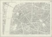
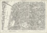
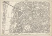
Three maps tell a story.

When the bridge to Charing Cross had 4 tracks, there was a small turntable at another site nearby just before the bridge on the south bank.

When the bridge was widened to 7 tracks, that had to be removed, though the map clearly shows it was not replaced immediately on the 3 track viaduct section.

Later on, likely when the 4th track was being added to the viaduct section, the new turntable was provided.
 
Last edited:

Snow1964

Established Member
Joined
7 Oct 2019
Messages
11,015
Location
West Wiltshire
Looking at large scale maps from the NLS website, it looks like the turntable went between 1951 & 1954, as did much of the structure under it.

A siding was extended into the remaining structure after that, until at least the mid-1960s.

I shall have to make a visit sometime this week, as I'm thinking that what survives is part of the structure that supported the turntable. It will be interesting to see if there is any evidence remaining to show that the structure was cut back.
Yes that was when the Festival of Britain site was cleared to build the Shell Centre (the offices of the oil company of same name)

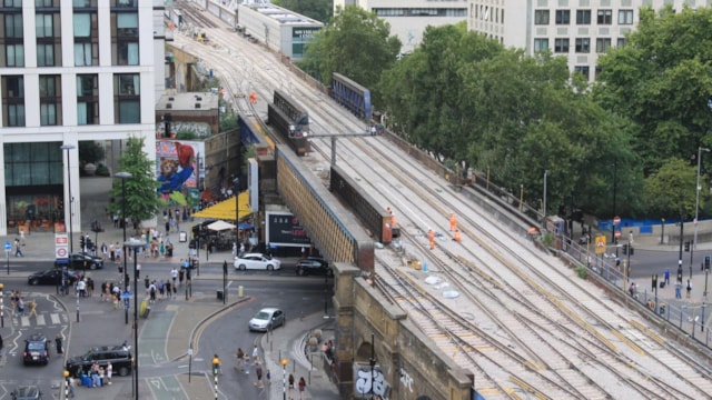
The stub of viaduct towards the turntable is clearly visible in the recent Network Rail photo following relaying the track between Waterloo East and Charing Cross. It now appears to have a large Paddington Bear painted on it.


The original approach was 3 track, the extra track has different bridges (was done about 1902)
 

Rescars

Established Member
Joined
25 May 2021
Messages
2,517
Location
Surrey
Belvedere turntable was 50’ 2” and I am not sure if that was long enough for a Schools. Ewer Street was long enough as it was 54’ 10”; it closed in 1962. There was also a turntable at Stoney Street to the east of Cannon Street South Junction, but I think that this had disappeared before the early 1950s.
Easy to forget at this distance in time, the restrictions on steam loco design and operations created by limitations in the size of turntables.
 

Big Jumby 74

Established Member
Joined
12 Feb 2022
Messages
2,217
Location
UK
The stub of viaduct towards the turntable is clearly visible in the recent Network Rail photo following relaying the track between Waterloo East and Charing Cross. It now appears to have a large Paddington Bear painted on it.

Looking at that view now, it is strange to me, that twenty plus years ago I use to walk past that frequently on my lunch break and never noticed the viaduct type structure (that which held the turn table) to my left as I walked North across Hungerford Bridge. Probably distracted by all the graffiti. Never had mobile phones in those days, and have never been distracted by them anyway - just for the record...:lol:
 

Port Road

Member
Joined
27 Sep 2025
Messages
84
Location
Scotland
I see where you come from, but the sidings are at a higher level, as are the two cabins seen 'above' (in the image) the stabled rolling stock. To the right of the buffers there is a retaining wall, the shadow from which can be seen in the access road it protected, coming from York Road. The image can be deceptive if one is unfamiliar with the ground level detail etc.

Also working at Waterloo for many years I was able to take the attached (amongst others) from the station roof during the rebuilding for the then new International station, and is one of my collection that I have since donated to the South Western Circle (https://lswr.org) for their archive. It clearly shows the ground level of the North Sidings as was, including the lift shaft of the old W&C Anderson lift, but crucially also shows the retaining wall and the lower level access road that went out (right) to York Road.

Apologies for veering slightly OT here btw!
Spot on. You're right enough, should have worn my glimmers! :rolleyes:
 

30907

Veteran Member
Joined
30 Sep 2012
Messages
21,922
Location
Airedale
Otherwise turning steam locos for Charing Cross services would be a right nuisance, they would have to run light engine tender first for a considerable distance, wasting line capacity, to get to the entrance to Bricklayers Arms shed. Shunting round three sides of the Cannon Street triangle would be even more inconvenient.
Belvedere turntable was 50’ 2” and I am not sure if that was long enough for a Schools. Ewer Street was long enough [for a Schools]. it was 54’ 10”; it closed in 1962.
There was plenty of loco working (often with ECS) to and from CST, reducing the direct movements to/from Rotherhithe Rd sidings (and BA shed).
Clearly the loss of Belvedere turntable caused minimal problems, and even the surviving siding was little used; paths to/from Ewer St weren't too great a problem on a 4--track railway.
One factor of course was the arrival of Bulleid Pacifics to work the Folkestone route - way too long for either turntable.
 

Taunton

Veteran Member
Joined
1 Aug 2013
Messages
12,218
Ewer Street would have been a bit of a nuisance to get to, on the opposite side of the 4-track to the longer Charing Cross platforms and approach tracks which steam services used, and I think across the Blackfriars spur tracks as well.

The 1957 Lewisham accident report shows the issues for getting locos there, the colliding BB 4-6-2 actually came from Stewarts Lane, longwindedly via Blackheath (indeed over the viaduct it later demolished), reversing to Bricklayers Arms, attached to the stock, pulled up towards New Cross, then the whole formation pulled in reverse by a pilot into Cannon Street
 

35B

Established Member
Joined
19 Dec 2011
Messages
5,362
Charing Cross was still being used by 'Schools' 4-4-0s on Hastings (and some Kent) services, which would find it convenient to be turned there. The Hastings trains were dieselised in 1957 and, seeing a comment above about the turntable being removed in 1954, one would have expected it to last until a project that must have been in hand by then to be implemented. Otherwise turning steam locos for Charing Cross services would be a right nuisance, they would have to run light engine tender first for a considerable distance, wasting line capacity, to get to the entrance to Bricklayers Arms shed. Shunting round three sides of the Cannon Street triangle would be even more inconvenient.

The Schools 4-4-0s, the most powerful of that type, were apparently designed specifically because of old small turntables on the system, like this one.
The size of the Schools was driven by the restrictions on the Hastings line, which limited both loading gauge and length - the Maunsell 4-6-0s couldn't work the line. Being able to use short turntables was an advantage rather than a pre-requisite
 

30907

Veteran Member
Joined
30 Sep 2012
Messages
21,922
Location
Airedale
The 1957 Lewisham accident report shows the issues for getting locos there, the colliding BB 4-6-2 actually came from Stewarts Lane, longwindedly via Blackheath (indeed over the viaduct it later demolished), reversing to Bricklayers Arms, attached to the stock, pulled up towards New Cross, then the whole formation pulled in reverse by a pilot into Cannon Street
Yes, but the key there is that the stock came from Rotherhithe Road, which as you say was in an awkward location but B Arms was close by. At least the Chatham line trains were worked round via Ludgate Hill!
 

Mcr Warrior

Veteran Member
Joined
8 Jan 2009
Messages
17,152
Could the turntable have been slightly nearer to Belvedere Road?
For the avoidance of doubt, was that a different, albeit nearby, turntable, or the exact same one that's the subject of this thread?
 

Geoff_K

Member
Joined
3 Mar 2021
Messages
74
Location
Crayford
For the avoidance of doubt, was that a different, albeit nearby, turntable, or the exact same one that's the subject of this thread?
The one that's the subject of this thread - The Belvedere Turntable.

I was just thinking that there wasn't room for a turntable between the stub viaduct & York Rd, but it's obvious from the various images, & maps, that there was.

Many thanks to everyone that has contributed to this thread so far - I look forward to seeing what other information emerges.
 

swt_passenger

Veteran Member
Joined
7 Apr 2010
Messages
34,227
I see where you come from, but the sidings are at a higher level, as are the two cabins seen 'above' (in the image) the stabled rolling stock. To the right of the buffers there is a retaining wall, the shadow from which can be seen in the access road it protected, coming from York Road. The image can be deceptive if one is unfamiliar with the ground level detail etc.
I think that retaining wall surrounded the original York Road entrance to the Bakerloo station. The passageway from the street would have passed under the cabins you mention.

I’ll add a link to the LT Museum web site which has a few photos from around 100 years ago:
Then this older photo seems to show that the underground station was cut into an earth embankment:
 
Last edited:

Big Jumby 74

Established Member
Joined
12 Feb 2022
Messages
2,217
Location
UK
I think that retaining wall surrounded the original York Road entrance to the Bakerloo station. The passageway from the street would have passed under the cabins you mention.
Thanks for your input. I will take time to read and digest.

But off the cuff initially so to speak, the retaining wall and associated access route from York Road (as per my own image during the demolition of that area in 1989/90), is to the North of the location of those two cabins in the aerial image posted further back - I think?

From what you say, I'm guessing there may have been two separate access routes from York Road in to the wider environs of Waterloo over time, one Bakerloo line associated, the other as per my image. Looking at my image the access road appears to be on an upward incline from York Road - was this a later modification of what may have been an earlier descent from York Road to the Bakerloo perhaps?

It's a fascinating subject (for me) and one which will always throw up new surprises now and again. If only to be a fly on the wall in the area circa 1848-1922...:lol:

PS:

Just re-reading your reply of today about the retaining wall and the passageway (under the cabins): we are talking of two different access points off York Road, am I right?
 
Last edited:

swt_passenger

Veteran Member
Joined
7 Apr 2010
Messages
34,227
Thanks for your input. I will take time to read and digest.

But off the cuff initially so to speak, the retaining wall and associated access route from York Road (as per my own image during the demolition of that area in 1989/90), is to the North of the location of those two cabins in the aerial image posted further back - I think?

From what you say, I'm guessing there may have been two separate access routes from York Road in to the wider environs of Waterloo over time, one Bakerloo line associated, the other as per my image. Looking at my image the access road appears to be on an upward incline from York Road - was this a later modification of what may have been an earlier descent from York Road to the Bakerloo perhaps?

It's a fascinating subject (for me) and one which will always throw up new surprises now and again. If only to be a fly on the wall in the area circa 1848-1922...:lol:

PS:

Just re-reading your reply of today about the retaining wall and the passageway (under the cabins): we are talking of two different access points off York Road, am I right?
Yes I think so - so looking at the underground entrance the minor road junction off York Rd would be to the left. I’ve linked to a 1916 25” map which has the station marked, and also has the Belvedere Road signal box present.

(On the NLS Maps website there are sometimes more maps hidden away that don’t show if using the side by side comparison.)

IMG_1861.jpeg

[extract from 1916 25” to the mile map of the Waterloo Station and Hungerford Bridge area.]

 
Last edited:

Big Jumby 74

Established Member
Joined
12 Feb 2022
Messages
2,217
Location
UK
Yes I think so - so looking at the underground entrance the minor road junction off York Rd would be to the left

Thank you. A small snippet from the past - being on duty at Waterloo in a volunteer capacity during the Michael Fish storm of 198x whenever, I was one of two assigned to the more recent elevated York Road entrance to the main concourse on the Windsor side, which had been taped (roped) off due to falling glass from the station roof, so our job was to advise anyone entering that the way to go was back round via the Victory Arch.

One 'gentleman' (somewhat tanked up) on being given advice accordingly, was having none of it, and was intent on entering the station via the closed route. Fortunately before discussions with said gent became too heated, an old school burly officer of the Law arrived on scene, and asked if we were having any problems. A brief discussion ensued and the gent concerned was escorted through a locked door in the passageway wall and down a flight of steps to the area in my North Siding image above , and given his marching orders.

We had no further problems after that!

The way things were dealt with back then may not be PC in todays world, but am I bothered....!

== Doublepost prevention - post automatically merged: ==

Yes I think so - so looking at the underground entrance the minor road junction off York Rd would be to the left. I’ve linked to a 1916 25” map which has the station marked, and also has the Belvedere Road signal box present.

(On the NLS Maps website there are sometimes more maps hidden away that don’t show if using the side by side comparison.)
Thanks for that further map image. It clearly shows what appears to be a structure relating to the entrance to the 'Elec. Ry sta' (ie: Bakerloo) that is 20-30 yards South of the access road to which I referred. That is brilliant, thank you.
This also confirms that the North Sidings (Waterloo Main Windsor side) were always at a higher level, in line with the platforms at Waterloo, as I had assumed.
 
Last edited:

NaZzAtAzEr

Member
Joined
29 Mar 2018
Messages
60
Someone already touched on it, but sitting on top is the relay room for Charing Cross. The arches were occupied previously for the high rises/towers construction and is now abandoned. I had a little explore during the Charing cross blockade after a shift and I think there was 3 arches, definitely not two. Access was probably one of the more unusual ones for a relay room that I've been to, with a tight spiral staircase right through the middle.
 

Top