• Our new ticketing site is now live! Using either this or the original site (both powered by TrainSplit) helps support the running of the forum with every ticket purchase! Find out more and ask any questions/give us feedback in this thread!

Unbuilt Connection to London Waterloo?

Geoff_K

Member
Joined
3 Mar 2021
Messages
74
Location
Crayford
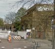
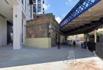
I've long been intrigued by this feature on the viaduct, by the BFI Imax in London, when travelling between Waterloo East & Charing Cross

I understand that London Waterloo was not originally intended to be a terminus, with the line continuing across the river.

So was this feature built as part of the intended extension?

Cheers

Geoff
 

Attachments

  • a.jpg
    a.jpg
    127.8 KB · Views: 214
Sponsor Post - registered members do not see these adverts; click here to register, or click here to log in
R

RailUK Forums

Mcr Warrior

Veteran Member
Joined
8 Jan 2009
Messages
17,152
Believe it's the one-time site, obviously up above the street level of Sutton Walk, of what was once a 1900s era railway turntable. Some sources say the building was later re-purposed as a café.
 

Rescars

Established Member
Joined
25 May 2021
Messages
2,516
Location
Surrey
At one time there was an extension from Waterloo to the SER, but it faced the other way and joined the SER at Waterloo Junction (aka Waterloo East) to provide through connections to the City at Cannon Street. Services were much reduced when the Waterloo and City line was opened.

== Doublepost prevention - post automatically merged: ==

Believe it's the one-time site, obviously up above the street level of Sutton Walk, of what was once a 1900s era railway turntable. Some sources say the building was later re-purposed as a café.
It doesn't look like a very wide area. Has it been reduced in size at some stage? If not, it can't have been a very big turntable.
 

Mcr Warrior

Veteran Member
Joined
8 Jan 2009
Messages
17,152
It doesn't look like a very wide area. Has it been reduced in size at some stage? If not, it can't have been a very big turntable.
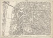
Difficult to say. This 1916 OS map link hopefully gives a better idea. Sutton Walk (then known as Sutton Street) is in the upper left of the map, just to the North of the Waterloo station complex. If you zoom in, it should be possible to discern the turntable site.
 

etr221

Established Member
Joined
10 Mar 2018
Messages
1,580
Difficult to say. This 1916 OS map link hopefully gives a better idea. Sutton Walk (then known as Sutton Street) is in the upper left of the map, just to the North of the Waterloo station complex. If you zoom in, it should be possible to discern the turntable site.
Yes, the turntable is visible. Thinking it wasn't built for anything bigger than a 4-4-0...
 

edwin_m

Veteran Member
Joined
21 Apr 2013
Messages
28,586
Location
Nottingham
Looking at it overlayed on a current map, it does look like modern buildings cover some but not all of the space with the turntable.
 

Rescars

Established Member
Joined
25 May 2021
Messages
2,516
Location
Surrey
Clearly some demolition has gone on, seeing the storage roads set out around the south west side the turntable. The map indicates that there was an indentation in the site along Manners Street. Does that indicate the point at which the railway site has been truncated to enable new building to take place? The brickwork in the photo at the top of the wall looks very complete and unmodified.

The turntable cannot have been very big, though big enough for a River class perhaps?!
 

Geoff_K

Member
Joined
3 Mar 2021
Messages
74
Location
Crayford
Thanks for everyone's information.

Given the position of the feature, I'm not sure how the turntable would have fitted in-between the feature, and York Road. Unless York Road has been slewed towards the former location of the turntable at some point?

Could the turntable have been slightly nearer to Belvedere Road?

It would be very interesting to see a map from when more of the buildings from the 1916 period were surviving overlaid on the 1916 map.

The end of the feature doesn't look to me like it's been truncated. As Rescars says, the brickwork doesn't look like it's been modified, which is why I've always thought that the feature was built to enable an planned future connection to Waterloo.
 

Mcr Warrior

Veteran Member
Joined
8 Jan 2009
Messages
17,152
I'd say that what's left of the elevated turntable structure building occupies maybe two-fifths of the footprint of what it once did.

Almost certainly NOT an unbuilt connection to London Waterloo
 

Gloster

Veteran Member
Joined
4 Sep 2020
Messages
12,940
Location
Up the creek
A look at various large scale maps suggest that there was still a turntable there until 1951: it quite possibly that it saw the opening of the Festival of Britain on the surrounding land. It then disappeared and it looks as though within the next few years the area was reduced and the yellow-brick building that is still there covers only part of the area that the turntable did. You would need a pre-1951 ground-level view to be sure just what was there before.
 

norbitonflyer

Established Member
Joined
24 Mar 2020
Messages
5,657
Location
SW London
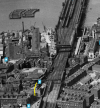
The turntable was evidently still there in 1951. Here is an artist's impression of the Festival of Britain site, in which the turntable can be seen.
51902327319_841ecf4b7d_b.jpg
 

etr221

Established Member
Joined
10 Mar 2018
Messages
1,580
Looking on the NLS website, they have editions of the relevant OS 25inch plan (TQ3080SE) surveyed in March (which has the TT) and June (which doesn't!) 1951.
 

Geoff_K

Member
Joined
3 Mar 2021
Messages
74
Location
Crayford
Looking at large scale maps from the NLS website, it looks like the turntable went between 1951 & 1954, as did much of the structure under it.

A siding was extended into the remaining structure after that, until at least the mid-1960s.

I shall have to make a visit sometime this week, as I'm thinking that what survives is part of the structure that supported the turntable. It will be interesting to see if there is any evidence remaining to show that the structure was cut back.
 

Mcr Warrior

Veteran Member
Joined
8 Jan 2009
Messages
17,152
Having established roughly when the turntable went, anyone able to hazard a guess as to when it was installed? Maybe when the line into Charing Cross was opened, so ~1864? Or later than that?
 

etr221

Established Member
Joined
10 Mar 2018
Messages
1,580
Not when the line was built, and it wasn't on the 1894 map. The widening of the line into Charing Cross was between then and 1902: my assumption is that the turn table was installed as part of that project.
 

30907

Veteran Member
Joined
30 Sep 2012
Messages
21,922
Location
Airedale
The 1:1250 maps of 1951 show two different versions of the Festival of Britain site (amazing that the OS recorded such ephemera!) and in the second the turntable has been covered by an unspecified building. Belvedere Rd Bridge still shows where the siding joined the Up Fast.

I think the Shell Centre may have eaten into the area.

The remaining siding is still in use early in 1957 (I've skimmed Gammell's SR loco Workings book) and is listed as Belvedere Sidings, but there are only a couple of entries, so I suspect it may have fallen out of use shortly after with the advent of the Hastings diesels - Ewer St provided an alternative.
 

Geoff_K

Member
Joined
3 Mar 2021
Messages
74
Location
Crayford
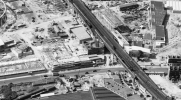
Those aerial photos are really useful, so thanks for finding them.

These confirm, I think, that the structure that supported the turntable was cut down, & everything to the left of the yellow line in the image below was demolished.

It will be interesting to see if there are traces of lost walls on what is now an external wall.
 

Attachments

  • #1921.png
    #1921.png
    530 KB · Views: 71

stuving

Member
Joined
26 Jan 2017
Messages
722
The use of this area in the Festival of Britain is shown in the attached image, taken from the wayfinding plan in the official "brochure". Here York Road runs across the bottom, and Sutton Walk is the diagonal road, going under the Charing Cross line that runs vertically up the central page fold. The pink shape marked H is that odd remnant building and was "the Turntable Cafe". The northern part of that building housed the "the British Today" section of the "the People of Britain" pavilion.

On the back of that page was a photo of the area from County Hall in 1949, but it's so indistinct I'm not even sure if the turntable is in it or not!
1786920809445.png
 

swt_passenger

Veteran Member
Joined
7 Apr 2010
Messages
34,227
Those aerial photos are really useful, so thanks for finding them.

These confirm, I think, that the structure that supported the turntable was cut down, & everything to the left of the yellow line in the image below was demolished.

It will be interesting to see if there are traces of lost walls on what is now an external wall.
If you have a play with Google Streetview and look at historic dates (stay on York Road though), you can get an idea of the side facing the previous Shell Centre underground parking ramp from around 2015, they seem to have done a fairly good job in disguising it.
 

Attachments

  • IMG_1859.jpeg
    IMG_1859.jpeg
    336.3 KB · Views: 84

Prime586

Member
Joined
26 May 2023
Messages
286
Location
Knowsley
There is a clearer version of one of the aerial survey images dating from 1950 on this website, that shows the turntable building during conversion for the Festival of Britain, with the other buildings being constructed around it. It looks like the tracks off the turntable were used to stable small station pilot engines for Charing Cross. There is another view of the top floor of the cafe that was built over the turntable during the Festival at viaduct level here, showing that there was still a headshunt in place on the stub of the viaduct.

It looks to have been built some time after the viaduct for Charing Cross was constructed in the 1860s, though the plot of land seems to have been reserved for it when the original buildings were cleared. As the site I linked to mentions, there were reports in contemporary newspapers of engines overshooting the turntable and knocking sections of the wall down to the floor below.

The ground floor appears to have been formed from two large arches (possibly used as a means of dumping ash to waiting carts or lorries), the remains of which could still be seen in the truncated building seen in the old Street View image.

The section that remains was the south-eastern corner of the building. the rest of the building was demolished in 1957 to build one of the 'wings' of the Shell Centre, which itself has since been demolished and the site is now occupied by Southbank Place. The remaining part of the turntable building looks like it houses a substation or equipment room for the railway at track level, which is probably why it needed to be retained.
 
Last edited:

Taunton

Veteran Member
Joined
1 Aug 2013
Messages
12,218
Yes, the turntable is visible. Thinking it wasn't built for anything bigger than a 4-4-0...
Charing Cross was still being used by 'Schools' 4-4-0s on Hastings (and some Kent) services, which would find it convenient to be turned there. The Hastings trains were dieselised in 1957 and, seeing a comment above about the turntable being removed in 1954, one would have expected it to last until a project that must have been in hand by then to be implemented. Otherwise turning steam locos for Charing Cross services would be a right nuisance, they would have to run light engine tender first for a considerable distance, wasting line capacity, to get to the entrance to Bricklayers Arms shed. Shunting round three sides of the Cannon Street triangle would be even more inconvenient.

The Schools 4-4-0s, the most powerful of that type, were apparently designed specifically because of old small turntables on the system, like this one.
 

Prime586

Member
Joined
26 May 2023
Messages
286
Location
Knowsley
Charing Cross was still being used by 'Schools' 4-4-0s on Hastings (and some Kent) services, which would find it convenient to be turned there. The Hastings trains were dieselised in 1957 and, seeing a comment above about the turntable being removed in 1954, one would have expected it to last until a project that must have been in hand by then to be implemented. Otherwise turning steam locos for Charing Cross services would be a right nuisance, they would have to run light engine tender first for a considerable distance, wasting line capacity, to get to the entrance to Bricklayers Arms shed. Shunting round three sides of the Cannon Street triangle would be even more inconvenient.

The Schools 4-4-0s, the most powerful of that type, were apparently designed specifically because of old small turntables on the system, like this one.
It looks like it was taken out of use in 1951 for the Festival Of Britain. The turntable disappears from OS maps during the construction of the Festival site, though the building remains on the maps until most of it was demolished to build the Shell Centre in 1957. The archive photo I linked to in my post above shows a rooftop terrace was built on top of the turntable as part of it's conversion to the cafe, and a buffer stop was installed where the siding was cut back to where it used to enter the turntable.
 

swt_passenger

Veteran Member
Joined
7 Apr 2010
Messages
34,227
I see that Waterloo west Sidings came right down to road level in those days. I also notice a bridge signalbox in photo 1 that has gone in photo 2, any experts here that know what it was called?
Belvedere Road, closed 1926.
 

etr221

Established Member
Joined
10 Mar 2018
Messages
1,580
Charing Cross was still being used by 'Schools' 4-4-0s on Hastings (and some Kent) services, which would find it convenient to be turned there. The Hastings trains were dieselised in 1957 and, seeing a comment above about the turntable being removed in 1954, one would have expected it to last until a project that must have been in hand by then to be implemented. Otherwise turning steam locos for Charing Cross services would be a right nuisance, they would have to run light engine tender first for a considerable distance, wasting line capacity, to get to the entrance to Bricklayers Arms shed. Shunting round three sides of the Cannon Street triangle would be even more inconvenient.

The Schools 4-4-0s, the most powerful of that type, were apparently designed specifically because of old small turntables on the system, like this one.
There was a turntable, and loco servicing facilities, at Ewer Street, which I think lasted into the early 1960s, probably the end of steam into Charing Cross/Cannon Street.
 

Big Jumby 74

Established Member
Joined
12 Feb 2022
Messages
2,217
Location
UK
I see that Waterloo west Sidings came right down to road level in those days. I also notice a bridge signalbox in photo 1
I am uncertain to which sidings you refer? But if you mean the sidings at Waterloo (Main) that were adjacent to what was platform 21 (Windsor side), subsequently buried under the International station, although 'West' might be more accurate, they were known as the 'North Sidings' within the industry in later years.

These sidings never to my knowledge descended to road level, and OS maps from 1872, 1895-6, 1907 all show these sidings to be atop a raised area of ground, ie level, or very near level, with the main platform roads in the station. The rebuilding of 1900-1922 left these sidings where they were, and as they remained until 1989-90.

I can see the overhead signal box to which you refer, but not being a South Eastern man in my day, and hence not much interest in that area, I can't answer your question, although it appears Nicolas Lewis has just answered that question.
 

Gloster

Veteran Member
Joined
4 Sep 2020
Messages
12,940
Location
Up the creek
Belvedere turntable was 50’ 2” and I am not sure if that was long enough for a Schools. Ewer Street was long enough as it was 54’ 10”; it closed in 1962. There was also a turntable at Stoney Street to the east of Cannon Street South Junction, but I think that this had disappeared before the early 1950s.
 

Port Road

Member
Joined
27 Sep 2025
Messages
84
Location
Scotland
Belvedere Road; interesting. Thanks for that.

== Doublepost prevention - post automatically merged: ==

I am uncertain to which sidings you refer? But if you mean the sidings at Waterloo (Main) that were adjacent to what was platform 21 (Windsor side), subsequently buried under the International station, although 'West' might be more accurate, they were known as the 'North Sidings' within the industry in later years.

These sidings never to my knowledge descended to road level, and OS maps from 1872, 1895-6, 1907 all show these sidings to be atop a raised area of ground, ie level, or very near level, with the main platform roads in the station. The rebuilding of 1900-1922 left these sidings where they were, and as they remained until 1989-90.

I can see the overhead signal box to which you refer, but not being a South Eastern man in my day, and hence not much interest in that area, I can't answer your question, although it appears Nicolas Lewis has just answered that question.
I worked at Waterloo when I was a laddie, so know little of the Eastern Division either. I remembered the name of the sidings wrongly probably. I assumed the sidings in this picture [from the IanVisits website link provided earlier] were an older incarnation of them, wagons can be seen at the buffer ends next to the main road.
 

Attachments

  • Waterloo Shell Centre 1952.png
    Waterloo Shell Centre 1952.png
    1.2 MB · Views: 50
Last edited:

Top