• Our new ticketing site is now live! Using either this or the original site (both powered by TrainSplit) helps support the running of the forum with every ticket purchase! Find out more and ask any questions/give us feedback in this thread!

Mystery station - Manchester area?

stuving

Member
Joined
26 Jan 2017
Messages
722
I'm beginning to doubt that is Audenshaw. The bridge is identified as Snipe Bridge, and there picture on Facebook, showing it as an iron plate bridge. The plan shows a dividing girder own the middle, and the platforms do not run across the bridge. So the view can't be in that direction - but that's the way that puts the signal in the same place as the later maps.

If the view is the other way, there should be a a bridge about a platform-length further on (also with a dividing girder). Would that be visible? I think so. And a weak indication: the trees you can see are not on the 25" map, though a lot of others are.

Incidentally, what I think is the original building at the foot of the embankment on the road is still there. So is the Snipe Inn, source of the name, just to the east along the main road.
 
Sponsor Post - registered members do not see these adverts; click here to register, or click here to log in
R

RailUK Forums

Gloster

Veteran Member
Joined
4 Sep 2020
Messages
12,940
Location
Up the creek
If it is looking south, which I think it must be as the bridge over Manchester Road should be visible, I think it is quite possible that the bridge over Slate Lane was far enough away for any girders to be lost in the general blurring.

I would not rely on the OS’s marking of signals as I have come across errors occasionally.
 

edwin_m

Veteran Member
Joined
21 Apr 2013
Messages
28,590
Location
Nottingham
The 25" NLS map, which shows the area where the platforms were so post-dates closure, doesn't show a centre girder or any track widening for it, which should show up at this scale. In the OP one of the staff is blocking where the dividing girder would be, although there is no widening of the tracks so if one is present it must be quite thin. The plan linked above is pretty indistinct, and I'm not certain that what appears to be a centre girder actually is that. There is also no signal box shown, and the only nearby signal matches the one in the photo and is in about the right place to be the distant for Ashton Moss.

 
Last edited:

Wearhead

Member
Joined
11 Jul 2014
Messages
19
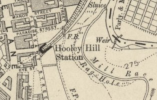
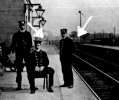
I'm a bit late to the party, but surely this is Hooley Hill station? Slight ajustment of the contrast shows (to my eyes) the highly distinctive skew footbridge (arrowed) which crosses to the north-east of the station. To the right, between lampposts three and four there is a patch of water, which is possibly the river or sewage beds shown on the map. Finally no-one has mentioned the steps in the lower left-hand corner, (see OP) which would be the bottom of the steps from Mount Pleasant Street onto the platform.
No idea about the signalling, that's way above my pay grade.
 

Attachments

  • CC-BY(NLS).png
    CC-BY(NLS).png
    181.4 KB · Views: 68
  • Hooley Hill detail.jpeg
    Hooley Hill detail.jpeg
    54.7 KB · Views: 70
Last edited:

zwk500

Veteran Member
Joined
20 Jan 2020
Messages
18,401
Location
Northampton
I'm a bit late to the party, but surely this is Hooley Hill station? Slight ajustment of the contrast shows (to my eyes) the highly distinctive skew footbridge (arrowed) which crosses to the north-east of the station. To the right, between lampposts three and four there is a patch of water, which is possibly the river or sewage beds shown on the map. Finally no-one has mentioned the steps in the lower right-hand corner, (see OP) which would be the bottom of the steps from Mount Pleasant Street onto the platform.
No idea about the signalling, that's way above my pay grade.
The station appears to be elevated above local ground level, not in a cutting adjacent to a tunnel. The line in the photo is also straight, not on a curve
 

Efini92

Established Member
Joined
14 Dec 2016
Messages
2,137
The station appears to be elevated above local ground level, not in a cutting adjacent to a tunnel. The line in the photo is also straight, not on a curve
Could it be Dukinfield and Ashton station? That was elevated.
 

Wearhead

Member
Joined
11 Jul 2014
Messages
19
The station appears to be elevated above local ground level, not in a cutting adjacent to a tunnel. The line in the photo is also straight, not on a curve
Fair enough. I have also amended my post to correctly say the lower left-hand corner of the photo is where the stairs are.
 

montyburns56

Member
Joined
5 Oct 2015
Messages
178
I've put the picture through an AI enhancer which has improved it, but doesn't actually answer your question.


IMG_7868.jpg
 

Mcr Warrior

Veteran Member
Joined
8 Jan 2009
Messages
17,154
What does the smaller print (in white lettering) underneath / alongside the "Wagstaff's Pianos" advertising sign, actually say?
 

SuspectUsual

Established Member
Joined
11 Jul 2018
Messages
6,671
What does the smaller print alongside / underneath the "Wagstaff's Pianos" advertising sign, actually say?

“Manchester” directly underneath

Then on the left I would say three branch addresses given there’s a short initial word/number then a space then a longer one

The second line could be “xx Piccadilly”??
 

GarethW

Member
Joined
10 Dec 2010
Messages
193
The station appears to be elevated above local ground level, not in a cutting adjacent to a tunnel. The line in the photo is also straight, not on a curve
To my eyes the line in the distance is starting to curve slightly to the left.

(and thats before I looked at the AI enhancement which seems to comfirm).
 

Mcr Warrior

Veteran Member
Joined
8 Jan 2009
Messages
17,154
“Manchester” directly underneath

Then on the left I would say three branch addresses given there’s a short initial word/number then a space then a longer one

The second line could be “xx Piccadilly”??
Makes sense. The Albert Wagstaff piano business apparently did once have premises at 33 Piccadilly, in Central Manchester. Late 1890s era until maybe around 1916, which could help date the photo. In more recent years, NatWest Bank had a branch there.
 

Top