• Our new ticketing site is now live! Using either this or the original site (both powered by TrainSplit) helps support the running of the forum with every ticket purchase! Find out more and ask any questions/give us feedback in this thread!

Bizarre Northern Powerhouse rail map issued

Status
Not open for further replies.

321362

Member
Joined
31 Oct 2023
Messages
323
Location
London
616594618_1456652009152445_110397089735370779_n.jpg
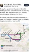
image shows a map shared on social media by the Mayor of West Yorkshire (can't link as don't have an account) showing potential Northern Powerhouse Rail upgrades. From west to east the stations are:
Liverpool, Warrington (connections to Chester), Manchester Airpont, Manchester Airport, Warrington, Warrington, Huddersfield, Huddersfield, Manchester Piccadilly (located just south of Sheffield), Sheffield (connections to Hull which is placed on the map somewhere north of Selby), Rotherham, Leeds, York, Hull (again) (just north of York), York (again) (just north of the New Hull), Newcastle (somewhere near Filey)
 
Last edited:
Sponsor Post - registered members do not see these adverts; click here to register, or click here to log in
R

RailUK Forums

Sun Chariot

Established Member
Joined
16 Mar 2009
Messages
6,644
Location
2 miles and 50 years away from the Longmoor Milita
View attachment 196020
image shows an (as far as I know) official proposed map for Northern Powerhouse Rail upgrades. From west to east the stations are:
Liverpool, Warrington (connections to Chester), Manchester Airpont, Manchester Airport, Warrington, Warrington, Huddersfield, Huddersfield, Manchester Piccadilly (located just south of Sheffield), Sheffield (connections to Hull which is placed on the map somewhere north of Selby), Rotherham, Leeds, York, Hull (again) (just north of York), York (again) (just north of the New Hull), Newcastle (somewhere near Filey)
That's an interesting map. I might be missing the obvious but what's mad and AI-created about it?
 
Last edited by a moderator:

TUC

Established Member
Joined
11 Nov 2010
Messages
5,072
A map issued to show the government's Northern Powerhouse rail plans has Hull moved inland, and appears twice, as does Huddersfield which puts in a second appearance at the end of the Leeds-Bradford rail line, and Manchester has moved south of Sheffield.

Even worse, Tracy Brabin, Mayor of West Yorkshire circulated it, as shown in the attached post. OK, she won't have designed the map, but what does it say about the geographical knowledge, or attention to detail, of those involved in the project that this was issued? One could argue it is stylistically designed, like the tube map, but that can't explain away all of these issues.
 

Attachments

  • IMG_0295.jpeg
    IMG_0295.jpeg
    144.9 KB · Views: 598

IC2000

Member
Joined
9 Mar 2023
Messages
5
Location
Witney
Generation by 'AI' unfortunately can explain all of these errors. A handy reminder that 'AI' does in fact know nothing, and just tries to generate something that might look accurate.
 

TUC

Established Member
Joined
11 Nov 2010
Messages
5,072
Generation by 'AI' unfortunately can explain all of these errors. A handy reminder that 'AI' does in fact know nothing, and just tries to generate something that might look accurate.
It is a good example of how AI does not excuse human beings from having responsibility for reviewing what is produced
 

800001

Established Member
Joined
24 Oct 2015
Messages
7,356
A map issued to show the government's Northern Powerhouse rail plans has Hull moved inland, and appears twice, as does Huddersfield which puts in a second appearance at the end of the Leeds-Bradford rail line, and Manchester has moved south of Sheffield.

Even worse, Tracy Brabin, Mayor of West Yorkshire circulated it, as shown in the attached post. OK, she won't have designed the map, but what does it say about the geographical knowledge, or attention to detail, of those involved in the project that this was issued? One could argue it is stylistically designed, like the tube map, but that can't explain away all of these issues.
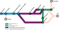
And the map was removed shortly after and the correct one was then issued.
Updated and correct image attached below.
This was the first one to come out. It was subsequently deleted and updated.
 

Attachments

  • IMG_8806.png
    IMG_8806.png
    71.6 KB · Views: 537

thejuggler

Established Member
Joined
8 Jan 2016
Messages
1,647
No Bradford either.

It is also unlikely the Mayor prepares and sends her own social media posts.
 

Trainguy34

Established Member
Joined
29 Apr 2023
Messages
1,231
Location
Kent
Might just be me but is "The government has commitment to" even correct grammar?
 

TUC

Established Member
Joined
11 Nov 2010
Messages
5,072
No Bradford either.

It is also unlikely the Mayor prepares and sends her own social media posts.
If you allow posts to be issued under your name, you bear responsibility for them, especially if you are in public office.

== Doublepost prevention - post automatically merged: ==

And the map was removed shortly after and the correct one was then issued.
Updated and correct image attached below.
But how did the first one even get issued without the errors being spotted? They're pretty obvious. If you work in the West Yorkshire Mayor's office, one assume that a knowlege of Yorkshire is a basic requirement.
 
Last edited:

AlterEgo

Verified Rep - Wingin' It! Paul Lucas
Joined
30 Dec 2008
Messages
29,422
Location
LBK
And the map was removed shortly after and the correct one was then issued.
Updated and correct image attached below.
The lazy, poop-from-a-butt AI generated one was removed and one was then uploaded which had been produced by a person, probably in a panic. The idea they posted the "wrong one" is cope.

AI is total cancer at the layperson level.
 

z444z

Established Member
Joined
17 Apr 2022
Messages
1,219
Location
London
And the North Sea by Newcastle has been turned into some kind of mountainous sunny paradise? Embarrassing to use AI for this instead of paying a graphic designer for a twenty minute job or even just using a freely available map tool.
 

AlterEgo

Verified Rep - Wingin' It! Paul Lucas
Joined
30 Dec 2008
Messages
29,422
Location
LBK
Yep, you can get a qualified guy in India to do this for £20 on Fiverr and it will be correct and accurate.
 

z444z

Established Member
Joined
17 Apr 2022
Messages
1,219
Location
London
Just to summarise, we’ve got Phase 1 from Leeds to Bradford. This links Huddersfield and Huddersfield to York via Leeds, and to Sheffield or maybe Manchester Piccadilly via Leeds and Rotherham. From York, there’s existing rail links to York via Hull. There are also existing rail links to Hull from Sheffield or maybe Manchester Piccadilly, and from Leeds (not via York).

There’s Phase 2 from Liverpool To Manchester. This links Liverpool to Warrington via Warrington, Manchester Airport and Manchester Airport, and Warrington. There are existing rail links from Warrington to Warrington via Chester.

And Phase 3 from Manchester to Bradford, Leeds and Sheffield. This has a northern branch from Manchester Airport to Huddersfield after which it branches into two, one going to Huddersfield and the other to Leeds, and a southern branch from Warrington to Sheffield or maybe Manchester Piccadilly.
 

TUC

Established Member
Joined
11 Nov 2010
Messages
5,072
And the North Sea by Newcastle has been turned into some kind of mountainous sunny paradise? Embarrassing to use AI for this instead of paying a graphic designer for a twenty minute job or even just using a freely available map tool.
Even odder when the correct map which replaced the erroneous one was part of the government press release making its announcement so was clearly available.
 
Last edited:

Megafuss

Member
Joined
5 May 2018
Messages
888
Location
Spalding
A map issued to show the government's Northern Powerhouse rail plans has Hull moved inland, and appears twice, as does Huddersfield which puts in a second appearance at the end of the Leeds-Bradford rail line, and Manchester has moved south of Sheffield.

Even worse, Tracy Brabin, Mayor of West Yorkshire circulated it, as shown in the attached post. OK, she won't have designed the map, but what does it say about the geographical knowledge, or attention to detail, of those involved in the project that this was issued? One could argue it is stylistically designed, like the tube map, but that can't explain away all of these issues.
These aren't serious people when it comes to transport. Even a Crayonista would have created something better!!
 

TUC

Established Member
Joined
11 Nov 2010
Messages
5,072
Let me guess it was created by a junior member of staff in Tracy Brabin’s Comms. team who, faced with being asked to include a map, their first response was to ask AI to do it for them rather than taking 30 seconds to search for the map themselves. If so, that speaks volumes and is a deeper concern.
 
Last edited:

omnicity4659

Member
Joined
25 Sep 2017
Messages
234
Let me guess it was created byca junior member of staff in Tracy Brabin’s Comms. team who, faced with being asked to include a map, their first response was to ask AI to do it for them rather than taking 30 seconds to search for the map themselves. If so, that speaks volumes and is a deeper concern.
It looks like they just took the existing map and put it through AI to overlay it onto a more interesting background…
 

YorksLad12

Established Member
Joined
5 Feb 2020
Messages
2,709
Location
Leeds
Let me guess it was created by a junior member of staff in Tracy Brabin’s Comms. team who, faced with being asked to include a map, their first response was to ask AI to do it for them rather than taking 30 seconds to search for the map themselves. If so, that speaks volumes and is a deeper concern.
I'm going to have to take issue with that, as a former member of the WYCA comms team (which covers more than just the Mayor‘s office). If it came from DfT it would have been included without question (because they always know what they’re doing, write?). If it was done in-house it wouldn’t have been thrown in without someone else looking at it.

We don’t know where it came from and who signed off on it, but blaming a “junior” is wrong.
 

Harpers Tate

Established Member
Joined
10 May 2013
Messages
2,047
Perhaps the initial thinking was to relocate Hull (all of it) further inland to save money on rail upgrades. And to build a second airport for Manchester.
 

z444z

Established Member
Joined
17 Apr 2022
Messages
1,219
Location
London
Perhaps the initial thinking was to relocate Hull (all of it) further inland to save money on rail upgrades. And to build a second airport for Manchester.
And build a second Hull too. And two new Warringtons. And a second York. And another Huddersfield. Also move Manchester to Sheffield to create Mancheffield.
 
Status
Not open for further replies.

Top