• Our new ticketing site is now live! Using either this or the original site (both powered by TrainSplit) helps support the running of the forum with every ticket purchase! Find out more and ask any questions/give us feedback in this thread!

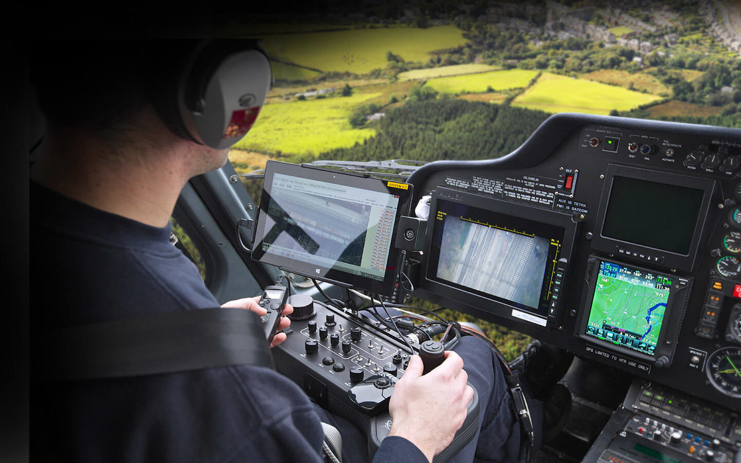
Where is the Network Railcopter overhead in this cockpit view pic?

Status
Not open for further replies.

RailAleFan

Member
Joined
2 Jul 2014
Messages
337
Location
Midlands
Can anyone figure it out?

advanced-aerial-technology-applied.jpg


Image shows a cockpit view of an aerial survey helicopter on railway ops, a section of track can be seen on a screen on the operator's console;
 
Last edited:
Sponsor Post - registered members do not see these adverts; click here to register, or click here to log in
R

RailUK Forums

edwin_m

Veteran Member
Joined
21 Apr 2013
Messages
28,749
Location
Nottingham
Looks to me like a photoshop of an interior with an exterior which is possibly just a stock aerial view.
 

D6975

Established Member
Joined
26 Nov 2009
Messages
3,053
Location
Bristol
If that were the case the background probably would not have been out of focus.
 

choo.choo

Member
Joined
17 May 2022
Messages
55
Location
UK
If the background were photoshopped, I would probably guess here at Seven Kings station in Ilford.

51°33'48.6"N 0°05'32.8"E
https://maps.app.goo.gl/aDDACMuCb8Agn2aH9

The imagery and radar frequencies on the GPS display look like London City Airport to me, which would suggest the helicopter is pointing at a heading of 075 a few miles north west of the airport. And this is the only bit of track i can find that looks roughly like the images on the screens.

Either I'm totally off with London City Airport or the background is Photoshopped.
 

jfowkes

Established Member
Joined
20 Jul 2017
Messages
1,271
If the background were photoshopped, I would probably guess here at Seven Kings station in Ilford.

51°33'48.6"N 0°05'32.8"E
https://maps.app.goo.gl/aDDACMuCb8Agn2aH9

The imagery and radar frequencies on the GPS display look like London City Airport to me, which would suggest the helicopter is pointing at a heading of 075 a few miles north west of the airport. And this is the only bit of track i can find that looks roughly like the images on the screens.

Either I'm totally off with London City Airport or the background is Photoshopped.
I agree it's definitely that location based on the map. Also the radio frequency is for Heathrow tower. The structure on the left-most camera then looks like a reasonable match to Aldborough Road South bridge.

I think the background is photoshopped, but they've done a pretty good job of it, all the little gaps in the cockpit are filled in. The camera operator's head has been weirdly replaced with the background just above his headphones which does make me think photoshop. Also, it's clearly not London!
 
Last edited:

Nottingham59

Established Member
Joined
10 Dec 2019
Messages
3,346
Location
Nottingham
The structure on the left-most camera then looks like a reasonable match to Aldborough Road South bridge.
Looks an exact match, even down to the tactile paving at each end of the span.

Except for a grey line across all four tracks at the bottom of that screen, which will be just to the West of the bridge. It looks like a portal structure, but Google's satellite view of the area shows a more substantial portal just to the East side of the bridge instead. Has there been any reconfiguration of the OHLE there recently?
 
Status
Not open for further replies.

Top