

Nottingham59
Established Member
The Castlefield viaduct is a notorious bottleneck that constrains the entire rail network in the North West. Ways round the constraint were discussed in this thread (now closed): https://www.railforums.co.uk/threads/potential-ways-round-the-castlefield-problem.249725/
Many have said that the cost of four-tracking would be prohibitive, so I thought I would have a go at working out how much that cost might be.
My proposal is a twin-track tunnel from Ashburys to the Chat Moss line, with just one underground station next to Piccadilly with two 200m platforms. I reckon that would cost £2.5Bn to get a working railway, with future enhancements to eventually support 16tph through this new NPR core. Is that affordable? Would it fix the problem?
EAST-WEST TUNNEL

This arrangement would give the Liverpool-Leeds connectivity that is needed for NPR, and keep East-West flows separate from North-South local traffic that would still use Castlefield.
WESTERN PORTAL
Working from West to East, the Salford portal would join the Chat Moss line, with grade separation. The River Irwell is 1.4km away, so the gradient would be moderate.

TUNNEL
Any tunnel under Manchester needs to avoid the nuclear command centre under much of China Town. This is why the aborted Pic-Vic tunnel curved south towards Princess Street, as shown here.
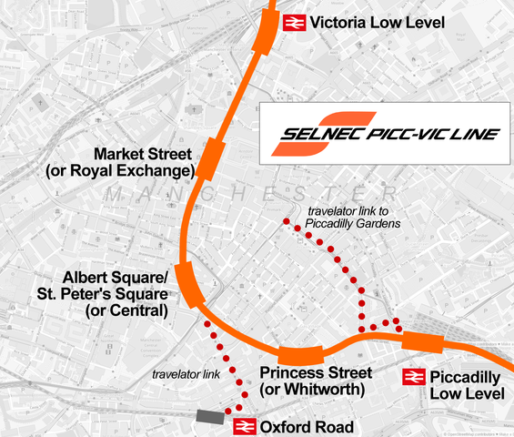
Otherwise, the tunnel can take whatever route is most convenient, as it would not have stations except at Piccadilly.
CENTRAL STATION
I reckon we only need one station in central Manchester and it should be at or very near Piccadilly. I'd propose locating it under Fairfield Street where a Pic-Vic station was planned, shown in red below. We only need two platforms as trains will not terminate. Trains from the west could use turnback sidings at Guide Bridge if necessary.

An alternative site, shown in yellow above, would be where the HS2 station was planned. This would be easier for construction access, but means that the station would be less conveniently situated. Either NPR station would be 10-15m below ground level to allow the line to pass below the river Medlock, so would not block the proposed alignment of the HS2 station, which was to be built 10m above ground level. Though of course, it would have to be compatible with any future resurrection of HS2. This diagram shows the side view of the HS2 station box with levels.

An even better site would have been directly under Mayfield Station, but that has now been redeveloped.
EASTERN PORTAL
The East NPR portal would be located on land immediately to the north of where HS2 was to transition into its tunnel. This land was to be bought for HS2 work and then returned for future development, so we know it is available. HS2 mapping can be found here: https://www.gov.uk/government/publi...lan-and-profile-maps-crewe-to-manchester-2022

The portal would need a gradient of around 1:50 to get over the Gorton Road bridge and join the northen pair of lines that passes through Ashburys station towards Guide Bridge. These would become the fast lines if extended all the way to Guide Bridge.
ESTIMATED COSTS
These figues use the cost estimates of new railway from: https://www.railforums.co.uk/threads/cost-of-new-railway-lines-in-2024.268709/
FUTURE ENHANCEMENTS
Recommended enhancements (not costed in the above, but needed to allow 16tph through the core)
Other enhancements would be possible. Feel free to discuss, but probably best in a new thread.
Many have said that the cost of four-tracking would be prohibitive, so I thought I would have a go at working out how much that cost might be.
My proposal is a twin-track tunnel from Ashburys to the Chat Moss line, with just one underground station next to Piccadilly with two 200m platforms. I reckon that would cost £2.5Bn to get a working railway, with future enhancements to eventually support 16tph through this new NPR core. Is that affordable? Would it fix the problem?
EAST-WEST TUNNEL
This arrangement would give the Liverpool-Leeds connectivity that is needed for NPR, and keep East-West flows separate from North-South local traffic that would still use Castlefield.
WESTERN PORTAL
Working from West to East, the Salford portal would join the Chat Moss line, with grade separation. The River Irwell is 1.4km away, so the gradient would be moderate.
TUNNEL
Any tunnel under Manchester needs to avoid the nuclear command centre under much of China Town. This is why the aborted Pic-Vic tunnel curved south towards Princess Street, as shown here.
Otherwise, the tunnel can take whatever route is most convenient, as it would not have stations except at Piccadilly.
CENTRAL STATION
I reckon we only need one station in central Manchester and it should be at or very near Piccadilly. I'd propose locating it under Fairfield Street where a Pic-Vic station was planned, shown in red below. We only need two platforms as trains will not terminate. Trains from the west could use turnback sidings at Guide Bridge if necessary.
An alternative site, shown in yellow above, would be where the HS2 station was planned. This would be easier for construction access, but means that the station would be less conveniently situated. Either NPR station would be 10-15m below ground level to allow the line to pass below the river Medlock, so would not block the proposed alignment of the HS2 station, which was to be built 10m above ground level. Though of course, it would have to be compatible with any future resurrection of HS2. This diagram shows the side view of the HS2 station box with levels.
An even better site would have been directly under Mayfield Station, but that has now been redeveloped.
EASTERN PORTAL
The East NPR portal would be located on land immediately to the north of where HS2 was to transition into its tunnel. This land was to be bought for HS2 work and then returned for future development, so we know it is available. HS2 mapping can be found here: https://www.gov.uk/government/publi...lan-and-profile-maps-crewe-to-manchester-2022
The portal would need a gradient of around 1:50 to get over the Gorton Road bridge and join the northen pair of lines that passes through Ashburys station towards Guide Bridge. These would become the fast lines if extended all the way to Guide Bridge.
ESTIMATED COSTS
These figues use the cost estimates of new railway from: https://www.railforums.co.uk/threads/cost-of-new-railway-lines-in-2024.268709/
- £50M: Western Portal structure
- £75M: New twin-track railway in portal (750m @ £100M/km)
- £75M: New line for Chat Moss grade separation (750m @ £100M/lm). This could be left for later, but with the route safeguarded.
- £1000M: Twin tunnel to Fairfield St (2.5km @ £400M/km)
- £500M: Twin platform underground station in box. Budget for Old Oak common was £1.67 at 2019 prices, but the outturn OOC cost may be two or three times this. OOC was much bigger, with 6x400m platforms underground and 8 platforms on the surface.
- £600M: Twin tunnel to East Portal (1.5km @ £400M/km)
- £50M: Eastern Portal structure
- £50M: New twin track railway to Ashburys West Junction (500m @ £100M/km)
- £100M: Sundries, such as turnback sidings somewhere.
FUTURE ENHANCEMENTS
Recommended enhancements (not costed in the above, but needed to allow 16tph through the core)
- New fast chord towards Wigan and Scotland using the alignment planned for the HS2 Golborne link
- New East to South chord at Newton-le-Willows to allow trains from Manchester to access the WCML slows with grade separation
- Use the exising third track at Eccles station as a fast avoiding line, with stoppers using the middle track as a bi-directional slow line.
- Add a third track at Patricroft station, with stoppers using the middle track as a bidirectional slow line
- Reinstate four-tracks from Ashburys to Guide Bridge, on existing alignment: northern pair fast, southern pair slow
- New Platforms at Guide Bridge station on the reinstated slow lines
Other enhancements would be possible. Feel free to discuss, but probably best in a new thread.
- Remove existing platforms at Guide Bridge and realign fast lines to curve towards Stalybridge at 1km radius raising line speed to 80mph.
- Make the Central Manchester station 400m long. This would allow 400m HS2 trains to reach Manchester via Newton-le-Willows, and immediately triple the capacity of HS2 phase 1 into Manchester.
- Three or four track the Chat Moss line between Eccles and Patricroft stations to allow fast trains to avoid stoppers
- Build turnback sidings at Guide Bridge (where the Freightliner depot is now) and add platforms with a multi-storey car park above to give a new P&R station with direct access from the M60.
- Add a second western portal to access the line to Bolton
- Additional tunnels from central manchester station to the WCML, at Longsight (1.5km away) or better after Slade Lane junction (3.5km).
- Or connect into the HS2 tunnels allowing HS2 services from London to Manchester to continue towards Scotland.
- Four track Stalybridge to Diggle by converting the Micklehurst Loop to Metrolink with some street running, to serve Mossley and Greenfield passengers with high fequency tram service. Reduce/eliminate stopping on the main line, giving non-stop fast line running from Manchester to Dewsbury
- Work out how to increase capacity into Liverpool from the Chat Moss route
- Add additional lines from Dewsbury to Leeds to deliver full NPR.
- Convert Castlefield into a 16tph S-bahn, serving local destinations on a 15-minute repeating timetable.


