jfuller595@gma
Member
Apparently, there are five manually operated crossing gates on the Anglia Network.
Is anybody able to name all five?
Is anybody able to name all five?



Submit a FOI request to get the data you're looking for, if you haven't already.This is for research. Network Rail claim that out of the five, Stonea is the 3rd most dangerous but they won't tell me which two they consider more dangerous.
I'd think Whittlesea is quite risky being on a relatively busy line (3 TOCs) and in a decent sized townThis is for research. Network Rail claim that out of the five, Stonea is the 3rd most dangerous but they won't tell me which two they consider more dangerous.
Genuinely forgot about FOI. I only submitted one recently asking how many times the Police were called to Stonea bridge over the past 5 years (works out about 5/6 times a year)Submit a FOI request to get the data you're looking for, if you haven't already.
I think I'm going to have a look this week. I did wonder about Whittlesea. Cheers!I'd think Whittlesea is quite risky being on a relatively busy line (3 TOCs) and in a decent sized town

I'd think Whittlesea is quite risky being on a relatively busy line (3 TOCs) and in a decent sized town

There is one at Brundall if I remember correctly
Does this one at Cantley count?View attachment 144576
- - - - - - - - - - - - - - - - - - - - - - - - - - - - - - - - - - - - - - - - - - - - - - - - - - - - - - - - - - - - - - - - - - - - - - - - - - - - - - - - - - - - - - - - - -
View attachment 144577
Some lovely level crossing action at Whittlesea

I think Littleport has gates.Stonea
Whittlesea
Elsenham
Can't think of the other two
Brundall went with the resginalling.
According to the March 2023 image on StreetView - yes, correct (on a freight-only line, near the end of the line).Middleton Towers branch?

I think Littleport has gates.
== Doublepost prevention - post automatically merged: ==
According to the March 2023 image on StreetView - yes, correct (on a freight-only line, near the end of the line).
View attachment 144584

@Bald Rick is very knowledgeable and may be able to explain the calculationsThe next thing I'm pondering is what method NR would use to calculate risk for these locations.
 www.networkrail.co.uk
Not an official answer:Great. The next thing I'm pondering is what method NR would use to calculate risk for these locations. According to an email from NR today, Stonea is the 3rd most risky.
Is it sheer coincidence that 3 out of these 5 are on the Fens? Does the landscape present challenges?
Elsenham had a near miss earlier this year see here:Elsenham now has a footbridge, but with so many steps..... and with its tragic history

 www.bbc.co.uk
The mother of a teenager who was killed by a train has criticised the "stupidity" of people who were nearly struck at the same level crossing.
Olivia Bazlinton, 14, and Charlotte Thompson, 13, were hit at the crossing in Elsenham, Essex, on 3 December 2005.
Recently released CCTV footage showed two people climbing around fencing to avoid the locked gates, with a fast train narrowly missing them.
Tina Hughes, Olivia's mum, said she was "horrified" when she saw the video.
That's helpful. Thank youNot an official answer:
More of a "coincidence" is that 3 out of the 5 are at stations, which will increase the risk to pedestrians (though Littleport has an underpass). Elsenham now has a footbridge, but with so many steps..... and with its tragic history, it's bound to rank no.1. I suspect Whittlesea might Stonea on footfall and marginally on train frequency.
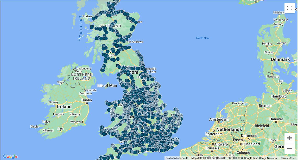
Thank youHere is a map of all level crossings
Active level crossings - Network Rail
Information about all our level crossings including type, location and risk assessments. Active level crossings map How to use this...
Regards,
Ian
That's very helpful. Thank you. Every time I contact Cambs Highways I'm told that they cannot do anything around the crossing as it falls under the jurisdiction of NR. NR sent me a map that shows that their "area of responsibility" which seems to extend past the merging point on the road. In practice, I don't know what this map means In regards to who maintains what.Level Crossing Risk is a complicated subject, far too detailed for me to go into in full.
In summary, the risk is that of a fatality at each crossing per year. It is calculated using an algorithm that has dozens of inputs, including the type of crossing, the type of highway or path crossing it, the nature of the crossing approach, use of the crossing (number of trains, their speed, how many passenegrs are on the trains), use of the crossing on the road / path (number of vehicles, bikes, pedestrians, and vulnerable users), crossing visibility, and the history of misuse / abuse at the crossing.
The output risk in terms of expected fatalities per year are normally rather small numbers, and these are converted into two scores:
A letter in the range A to M (A being highest, M being essentially 0) representing the individual risk to people on the path / road crossing the line
A number in the range 1 to 13 (1 being highest, 13 being essentially zero) representing the collective risk, which is to all people using the crossing either by road / path / train and also includes the risk to rail staff. This is the most important of the two scores.
The steps between each number or letter are effectively an order of magnitude, ie a ‘2’ crossing has a risk of fatality per year roughly 10 times greater than a ‘3’ crossing.
As it happens I know all these crossings very well, having visited 4 of them professionally and cycled across 4 as a road user. On the NR Level Crossing map they are scored as follows, and there are no surprises (I have ranked them in order)
Whittlesey C2
Elsenham C4
Stonea E4
Littleport G4
Middleton L10
There is another active Level Crossing on Anglia on a Public Highway with Gates - Trinity Lane just south of Cheshunt. It is ofen disregarded as a public highway, as it is only used by gardeners getting to their allotments.

Level Crossing Risk is a complicated subject, far too detailed for me to go into in full.
In summary, the risk is that of a fatality at each crossing per year. It is calculated using an algorithm that has dozens of inputs, including the type of crossing, the type of highway or path crossing it, the nature of the crossing approach, use of the crossing (number of trains, their speed, how many passenegrs are on the trains), use of the crossing on the road / path (number of vehicles, bikes, pedestrians, and vulnerable users), crossing visibility, and the history of misuse / abuse at the crossing.
The output risk in terms of expected fatalities per year are normally rather small numbers, and these are converted into two scores:
A letter in the range A to M (A being highest, M being essentially 0) representing the individual risk to people on the path / road crossing the line
A number in the range 1 to 13 (1 being highest, 13 being essentially zero) representing the collective risk, which is to all people using the crossing either by road / path / train and also includes the risk to rail staff. This is the most important of the two scores.
The steps between each number or letter are effectively an order of magnitude, ie a ‘2’ crossing has a risk of fatality per year roughly 10 times greater than a ‘3’ crossing.
As it happens I know all these crossings very well, having visited 4 of them professionally and cycled across 4 as a road user. On the NR Level Crossing map they are scored as follows, and there are no surprises (I have ranked them in order)
Whittlesey C2
Elsenham C4
Stonea E4
Littleport G4
Middleton L10
There is another active Level Crossing on Anglia on a Public Highway with Gates - Trinity Lane just south of Cheshunt. It is ofen disregarded as a public highway, as it is only used by gardeners getting to their allotments.
Assuming you mean Lincoln Road LC in Bush Hill Park, it is a Public Footpath Crossing with Whistleboards. So, yes, in short.Is Bush Hill Park (near Enfield Town) still manually operated?
Good point - that would make six, so I wonder if NR saying there are five crossings with manual gates means the Middleton Towers crossing wasn't included in their total?Nobody seems to have mentioned Dullingham (Key-Locks), adjacent to the station.
I dread to think what Motts Lane was scored before it was replaced with the bridge.Level Crossing Risk is a complicated subject, far too detailed for me to go into in full.
In summary, the risk is that of a fatality at each crossing per year. It is calculated using an algorithm that has dozens of inputs, including the type of crossing, the type of highway or path crossing it, the nature of the crossing approach, use of the crossing (number of trains, their speed, how many passenegrs are on the trains), use of the crossing on the road / path (number of vehicles, bikes, pedestrians, and vulnerable users), crossing visibility, and the history of misuse / abuse at the crossing.
The output risk in terms of expected fatalities per year are normally rather small numbers, and these are converted into two scores:
A letter in the range A to M (A being highest, M being essentially 0) representing the individual risk to people on the path / road crossing the line
A number in the range 1 to 13 (1 being highest, 13 being essentially zero) representing the collective risk, which is to all people using the crossing either by road / path / train and also includes the risk to rail staff. This is the most important of the two scores.
The steps between each number or letter are effectively an order of magnitude, ie a ‘2’ crossing has a risk of fatality per year roughly 10 times greater than a ‘3’ crossing.
As it happens I know all these crossings very well, having visited 4 of them professionally and cycled across 4 as a road user. On the NR Level Crossing map they are scored as follows, and there are no surprises (I have ranked them in order)
Whittlesey C2
Elsenham C4
Stonea E4
Littleport G4
Middleton L10
There is another active Level Crossing on Anglia on a Public Highway with Gates - Trinity Lane just south of Cheshunt. It is ofen disregarded as a public highway, as it is only used by gardeners getting to their allotments.

I dread to think what Motts Lane was scored before it was replaced with the bridge.
and a pain for stopping trains at Witham heading country bound.IIRC it was in the top 3 highest risk crossings in Anglia, something like a B3. It also cost a fortune to maintain.
Still part of the signalling system from what I can see especially when following a stopping service at Witham on the down. I think Long Green (Marks Tey) is too.and a pain for stopping trains at Witham heading country bound.