Our new ticketing site is now live! Using either this or the original site (both powered by TrainSplit) helps support the running of the forum with every ticket purchase! Find out more and ask any questions/give us feedback in this thread!
I think given the large number of other “3 arch overbridges” they will have just removed the north side embankment through it to make room for the third track that you mentioned in post #535. As far as the “before” drawings have it, most of the triples had the outer piers/abutments buried within the embankment, but built fairly deep. The Streetview of the road level brickwork shows no sign of the bridge being lengthened. The different feature here is that on the north side there is a near vertical retaining wall that’s been added either side of the abutment, rather than the normal sloping ground profile.
That makes sense. Especially if the only need to fit a single track under the north arch, leaving space to reinforce the foundations of the bridge abutments.
This picture gives an arial view ( 2 weeks ago), I did not appreciate the road under bridge , I see work has not started on the 2nd rail under bridge , to the IMD.
Lots to do , but very impressive .
Not quite, there’s a plan back in post #317, the HS2 infrastructure maintenance depot and siding connections is being built east of HS2 and on the north side of EWR. I suppose if you look at it as four quadrants around the EWR/HS2 crossing point then the western two will be least affected in the long term.
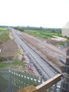
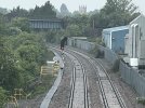
Remarkable progress with track-laying: Today I visited the overbrige on the Newton Longville road, next to the EWR B5 compound. A fully laid track now extends beyond this bridge. The track does indeed pass under the northside arch rather than the centre arch of the three. ( see photo) and can be seen to take a slight swerve to pass under this arch.
At the next accessible bridge, on the Mursley road (Swan's Way), I saw long lengths of rail laid on the black underlay sheet, but no sleepers yet.
The black underlay was also visible near the third bridge on the Mursley-Little Horwood road.
Remarkable progress in the two weeks since I last looked. I would have taken more photos, but the batteries in my camera failed.
Remarkable progress with track-laying: Today I visited the overbrige on the Newton Longville road, next to the EWR B5 compound. A fully laid track now extends beyond this bridge. The track does indeed pass under the northside arch rather than the centre arch of the three. ( see photo) and can be seen to take a slight swerve to pass under this arch.
At the next accessible bridge, on the Mursley road (Swan's Way), I saw long lengths of rail laid on the black underlay sheet, but no sleepers yet.
The black underlay was also visible near the third bridge on the Mursley-Little Horwood road.
Remarkable progress in the two weeks since I last looked. I would have taken more photos, but the batteries in my camera failed.
Thanks for that, it’s a similar shot to the middle one in your earlier post #532.
I think when you see long lengths of rail without sleepers it suggests the Balfour Beatty new track construction machine will be used to lay the sleepers and position the track.
Just to bolster Trainee9 update in post 545, here are some pics linked from the Phil Marsh twitter site at @Marshrail
== Doublepost prevention - post automatically merged: ==
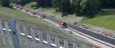
And a few more from Phil @Marshrail - Hopefully these will answer some of the comments earlier on the track laying machine workings, these from around the 11th May - Previous post on 15th May ish....
Looking at the last picture in particular it seems that a length of rails is laid out in front of this 'machine' which comes along, feeds them into it, attaches the sleepers and leaves behind it the completed track waiting for some ballast. Is that very basically correct or have I got it quite wrong?
Looking at the last picture in particular it seems that a length of rails is laid out in front of this 'machine' which comes along, feeds them into it, attaches the sleepers and leaves behind it the completed track waiting for some ballast. Is that very basically correct or have I got it quite wrong?
Hi guys , a few questions if Imay, as I'm in SW Scotland and too far to see these works directly ( I did with interest follow the first section that runs to London from Oxford? , At present is there. Tweedbank style ' temporary terminus '? Also how long was that first part and did it open around the same time as the first phase of the Borders line ?.
Second the HS2 bridge I think it is on page 18, ( great photos by the way, and wonderful to be able to see ) I take it the HS2 tracks run under the Oxford to Bletchely section of the reopened route above ?
Also given some bridges are shown as having previously had sidings ran through side portals , is there scope for such portals to be used for ' passing loops , for freight ?, Only given the ' green targets ' , it would be an awful waste , to not make full use of the line, by taking HGV's off the roads and their loads , put onto the rail network , also passing loops might allow for ' express ' high speed train paths?'
( On one technical drawing of this ' new/reopening) I note the line is parallel and twin track, running next to another twin track line , is this not part of the route ?.
Also I have a map from a rail magazine ( and an actual track atlas from years prior to the beeching cuts), both show this line originally was not a mainline , yet seems to be built to allow for To my untrained eye , at least the standard of the East coast mainline ( for example - I'm not too clued up on the real technical side of railways , just learning , in addition to the 00 gauge model rail, my interest is more toward this sort of thing , reversing the beeching cuts and types of trains used ).
So is this being built as a mainline to run for example at 110-125mph line speeds ? , I ask also because on the atlas from before closeure it appears to link to fairford near Cirencester, and Witney , Oxford is shown ( south of the line ) .
Also given the fact it will eventually ( hopefully) be taken all the way to Cambridge, and I cannot recal, but did read of a further eastern extension to link into another ' mainline ', that could in theory give a continuous route for the GWR High speed services , to run between Bath/Bristol and Cambridge, via Milton Keynes ? ( Bletchely bekng obviously part of this , and I assume , ' freeflow to use a road building parlance, ' chords ' to the Wcml and others it crosses , I ask as for example, East Midlands trains , run an east west service on the excellent, Class158 between Liverpool band Norwich, outside of their regular operating area , but having used that service it's popular.
Hence my question about GWR, as in theory they could run services all the way to Norwich , avoiding London and giving passengers an alternative, to going via London and changing trains .
What is the situation with the Aylesbury section? Was there sone question of it being left out or am I mistaking it for another location.
Calvert perhaps (although bad a child I lived in stony Stratford, and only took the train to Bedford on part of this line once , back in the 80's, being so far away I'm unsure of the finer details ).
Does this line have chords where it crosses the Ecml and MML?.
I only ask as I read a long time ago that this was the longest reopening in the UK , and the previous section since the Victorian era.
Finally, will it just be DMU/Chiltern on this route .
Or will As I asked , GWR/Cross country, be able to run ' express ' services , I ask as it wound seem to be a heck of a slog on a Turbo star ( the 158/159 is superior on a long distance run , hence why they use them on the route to the SW .
But with the class 800's that GWR run , would it not be beneficial to offer longer distance routes, especially as like I wrote above it bypasses London , ( kind of like Crossrail , on a larger scale )
Final question the method of track laying , I last saw this on the borders rail, but have always wondered , how does that machine ' stay in course ' plus does it ride the rails it has laid ? , This may sound like an obvious one to some, but my technical knowledge is IT, granted I have a good understanding of how they build bridges etc , that said , it seems amazing that with such amazing machines , these projects still in this time and era take most of a decade to build what the Victorians did in far less tine with Simple, hard labour and steam machinery ( read the Waverley route heritage association's story of that routes original construction), tunnels and cuttings dug, in far less time.
My apologies for the list of long winded questions, I'm genuinely interested, I'm not too sure what the situation is or why HS2 are involved in part of the line , or where the current terminus is.
Also I have a keen Interest in rail , but as I said it's more the closures and reopenings . Plus a railway to me is a right , not a privilege, one could argue , that taking so many lives, left us with the roads and climate chaos we have today.
This new line is an amazing thing to see being restored , if only more were underway .
It gives hope for other projects , for example , the Borders line , extension, or Oakhampton, already so busy that they had to do additional work, to allow a more frequent service , giving further hope to restoring beyond Oakhampton.
Personally, despite the convenience of a car, a rail journey with the right stock is less stressful more relaxing , and nicer than , endless jams, the cost of fuel etc, and the environment.
I for one , hope this line is eventually linked to its goal, and will no doubt be a huge success!.
Again apologies for all the questions, but they are all things I'd like to know and Google is not supplying the answer .
Best wishes to you all from my village Whithorn, SW Galloway ,a fromer branch of the closed , but proposed reopening , line to Cairnryan from Dumfries.
== Doublepost prevention - post automatically merged: ==
That makes sense. Especially if the only need to fit a single track under the north arch, leaving space to reinforce the foundations of the bridge abutments.
At present is there. Tweedbank style ' temporary terminus '? Also how long was that first part and did it open around the same time as the first phase of the Borders line ?.
Second the HS2 bridge I think it is on page 18, ( great photos by the way, and wonderful to be able to see ) I take it the HS2 tracks run under the Oxford to Bletchely section of the reopened route above ?
Also given some bridges are shown as having previously had sidings ran through side portals , is there scope for such portals to be used for ' passing loops , for freight ?, Only given the ' green targets ' , it would be an awful waste , to not make full use of the line, by taking HGV's off the roads and their loads , put onto the rail network , also passing loops might allow for ' express ' high speed train paths?'
There was a freight loop in the initial designs I think but it was not included in the final plans. The line isn't going to be that much use to freight at first as it only helps Southampton <> North WCML traffic but it is being built to W12. Passenger services do not generally get looped away from stations as it's a very inefficient usage of a train path.
( On one technical drawing of this ' new/reopening) I note the line is parallel and twin track, running next to another twin track line , is this not part of the route ?.
Also I have a map from a rail magazine ( and an actual track atlas from years prior to the beeching cuts), both show this line originally was not a mainline , yet seems to be built to allow for To my untrained eye , at least the standard of the East coast mainline ( for example - I'm not too clued up on the real technical side of railways , just learning , in addition to the 00 gauge model rail, my interest is more toward this sort of thing , reversing the beeching cuts and types of trains used ).
So is this being built as a mainline to run for example at 110-125mph line speeds ? , I ask also because on the atlas from before closeure it appears to link to fairford near Cirencester, and Witney , Oxford is shown ( south of the line ) .
Also given the fact it will eventually ( hopefully) be taken all the way to Cambridge, and I cannot recal, but did read of a further eastern extension to link into another ' mainline ', that could in theory give a continuous route for the GWR High speed services , to run between Bath/Bristol and Cambridge, via Milton Keynes ? ( Bletchely bekng obviously part of this , and I assume , ' freeflow to use a road building parlance, ' chords ' to the Wcml and others it crosses , I ask as for example, East Midlands trains , run an east west service on the excellent, Class158 between Liverpool band Norwich, outside of their regular operating area , but having used that service it's popular.
Hence my question about GWR, as in theory they could run services all the way to Norwich , avoiding London and giving passengers an alternative, to going via London and changing trains .
Does this line have chords where it crosses the Ecml and MML?.
There will be no connection to the ECML, and only a spur to the WCML but trains will share the MML briefly. However any thoughts of a Bristol-Cambridge are pretty optimistic. There was murmur about reading but even Didcot looks ambitious now. Oxford-Cambridge is still a fairly good connecting service.
What is the situation with the Aylesbury section? Was there sone question of it being left out or am I mistaking it for another location.
Calvert perhaps (although bad a child I lived in stony Stratford, and only took the train to Bedford on part of this line once , back in the 80's, being so far away I'm unsure of the finer details ).
EWR goes above HS2, the first picture in post #536 shows it, you can see the EWR formation heading off into the far distance where there’s an existing arch. Not yet visible in the photo, EWR will also go over a future chord from HS2 into the HS2 infrastructure depot. That will be further along behind the bridge abutments shown in the same picture.
Taken out of this thread https://www.railforums.co.uk/threads/east-west-rail-ewr-oxford-bletchley-construction-progress.216561/page-19#post-5661899 As I only later realised this was for CONSTRUCTION of Oxford - Bletchley, (and a jolly good thread too, if I may say so), and I was helping it go...
The Bletchley-Oxford line was fairly straight, so may look good for high speed running, but it was only a branch. When closed to passengers in 1967, I believe the line speed was probably 70 mph, though I'm not sure many DMUs which worked the line managed to reach that speed very often.
In a copy of 'Modern Railways' which I have seen, there is a photo of an Oxford-Cambridge train crossing the ECML at Sandy shortly before closure in 1967 hauled by a class 24 diesel-electric loco.
I'm pretty sure the foreshortening is exaggerating it, but also it doesn't look to me like the proper final formation so I'd expect a tamper to smooth it out.
I'm pretty sure the foreshortening is exaggerating it, but also it doesn't look to me like the proper final formation so I'd expect a tamper to smooth it out.
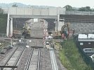
I think @Pete_uk might possibly be referring to the way the track separates out to use two separate arches at that particular bridge, in which case I don’t think it will be straightened. I think (like you) it’s probably more distorted by the camera.
We were discussing the possibility a few days ago that using two separate arches at that particular bridge might provide enough electrification clearance. It‘s unusual to do that as I couldn’t find another example of separating the tracks in the TWA bridge drawings.
We were discussing the possibility a few days ago that using two separate arches at that particular bridge might provide enough electrification clearance. It‘s unusual to do that as I couldn’t find another example of separating the tracks in the TWA bridge drawings.
Given the nature of the line, I'm surprised there's even one bridge that has two arches sufficient to give clearance - most bridges would have been built with only one central arch spanning both tracks, I'd have thought.
Interestingly, exactly the same does appear to have been done north of Market Harborough on the MML electrification thread.
Given the nature of the line, I'm surprised there's even one bridge that has two arches sufficient to give clearance - most bridges would have been built with only one central arch spanning both tracks, I'd have thought.
Interestingly, exactly the same does appear to have been done north of Market Harborough on the MML electrification thread.
I remember that discussion, I was just commenting on the apparent rarity of the arrangement.
Looking back at the photos there is one much more zoomed in than the others which does have a more severe 'kink' out for the arch, however the others look fairly smooth and the catch pits (if that's what they are) seem to indicate the track is on its final alignment, which should be fit for 100mph or so.
The bridge at Market Harborough formerly had four tracks under it. The same was done many years ago with the series of bridges going out of Bolton towards Lostock, also formerly four tracks, which were only electrified several decades later.
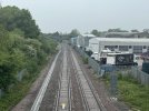
Few pics from Sunday's wander around Bicester. Unfortunately the new Charbridge Lane bridge is currently closed to pedestrians (not vehicles) and there's a diversion over the Jarvis Lane footbridge which is where I took these photos from.
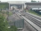
The new bridge at Charbridge Lane looking towards Launton
Looking towards Gavray Junction and Bicester Village station
Few pics from Sunday's wander around Bicester. Unfortunately the new Charbridge Lane bridge is currently closed to pedestrians (not vehicles) and there's a diversion over the Jarvis Lane footbridge which is where I took these photos from.
Good stuff. The first and second of your photos explain something that I’d been wondering about. The planning drawings had the right hand “wing wall”, (the triangular wall supporting the embankment), extending to the same distance as the left hand side. The decision to build a stone faced [1] supporting wall alongside the road embankment must be a later variation, I suppose it’s been done to avoid a normal full width embankment encroaching into the industrial site.
We are aware of an issue with emails from the Forum to Microsoft-based email accounts (hotmail/outlook/live.com email addresses). This is being looked into currently, thanks for your patience meanwhile.