
-
Our new ticketing site is now live! Using either this or the original site (both powered by TrainSplit) helps support the running of the forum with every ticket purchase! Find out more and ask any questions/give us feedback in this thread!
You are using an out of date browser. It may not display this or other websites correctly.
You should upgrade or use an alternative browser.
You should upgrade or use an alternative browser.
Why did New Beckenham have 3 tracks?
- Thread starter frankmoh
- Start date
- Status
- Not open for further replies.

Sponsor Post - registered members do not see these adverts; click here to register, or click here to log in
R
RailUK Forums

Sad Sprinter
Established Member
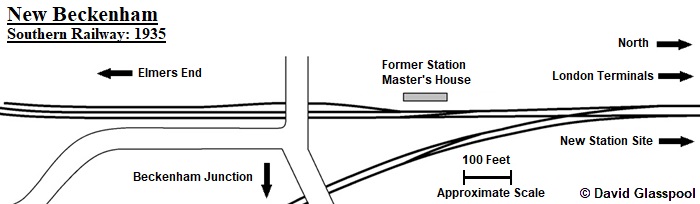
Track layout of New Beckenham, 1935, courtesy of David Glasspool from Kentrail
As the title says, why did New Beckenham have 3 tracks at one point? When were they removed?
I was wondering this last night! But I thought it was Bellingham that had this arrangement. Were there ever trains that terminated at Lower Sydenham and reversed there?
Bellingham does still have a 3-track section leading to the station, but it's a siding.I was wondering this last night! But I thought it was Bellingham that had this arrangement.
Gloster
Veteran Member
Maps from 1895, 1930 and 1954 all show it as a refuge siding. Probably chosen as the best place to put away a goods off either line that that might get in the way at St John’s.

It was a carriage siding for much of its life, not sure when it ceased to be used but pre-Networker.Maps from 1895, 1930 and 1954 all show it as a refuge siding. Probably chosen as the best place to put away a goods off either line that that might get in the way at St John’s.
New Beckenham itself had a centre road (which I assumed the OP was asking about!) - I believe it was used to allow up trains to be combined off both routes.
Confirmed by Hajducki's book: introduced in 1897 when the station was rebuilt, removed after electrification. The space is still there.
I have a vague recollection that the berthing siding was used for the Clock House emergency train (the Chaffinch Brook under that station being extremely prone to flood until about 1960).
Last edited:
Gloster
Veteran Member
It was a carriage siding for much of its life, not sure when it ceased to be used but pre-Networker.
New Beckenham itself had a centre road (which I assumed the OP was asking about!) - I believe it was used to allow up trains to be combined off both routes.
A look at various OS maps shows that the centre road did not appear until after 1894 and had gone by 1930. It looks, although the scale is small, as though it was only connected to the Up road.
The siding to the south appears to have been there both before and after the through road, although it may have been extended slightly at some point. The 1971 box diagram just shows it as ’Up Branch Siding’.
- Status
- Not open for further replies.