trainJam
Member
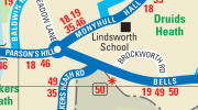
The image is from the Birmingham local area integrated transport map (https://www.tfwm.org.uk/plan-your-journey/discover-the-west-midlands/local-area-maps/), accessed 12th November 2023.
For comparison, in square A10, bus route 202 goes completely outside of the valid area.
If you look closely at square D10, bus route 49 seems to leave the light cream area (nBus and nNetwork validity zone) for a very small section of the route. It is not the easiest thing to spot, but I can see the grey dashed line above the dark blue road, implying that the road does cross into the dark side.
Theoretically, does this mean that nBus and nNetwork tickets are not valid here?
For comparison, in square A10, bus route 202 goes completely outside of the valid area.
If you look closely at square D10, bus route 49 seems to leave the light cream area (nBus and nNetwork validity zone) for a very small section of the route. It is not the easiest thing to spot, but I can see the grey dashed line above the dark blue road, implying that the road does cross into the dark side.
Theoretically, does this mean that nBus and nNetwork tickets are not valid here?