• Our new ticketing site is now live! Using either this or the original site (both powered by TrainSplit) helps support the running of the forum with every ticket purchase! Find out more and ask any questions/give us feedback in this thread!

Sheffield City Council's 'Second City Crossing' proposal for Supertram

TheGuy77

Member
Joined
21 Apr 2024
Messages
200
Location
Earth (obviously)
A consultation document published by Sheffield Council reveals that officials want to extend the network to include both the Royal Hallamshire Hospital, and the Moorfoot area of the city centre.
And they say that the scheme could open to door to extending it further in the future.

It seems like that they want to copy Manchester with a 'Second City Crossing', connecting Moorfoot and the Royal Hallamshire Hospital. I don't find it really necessary considering how few trams run in Sheffield compared to Manchester, but connecting it to the Moor would personally be great for me. The question is - what route do you think it will take?
 
Sponsor Post - registered members do not see these adverts; click here to register, or click here to log in
R

RailUK Forums

ricoblade

Member
Joined
28 Sep 2015
Messages
539
It seems like that they want to copy Manchester with a 'Second City Crossing', connecting Moorfoot and the Royal Hallamshire Hospital. I don't find it really necessary considering how few trams run in Sheffield compared to Manchester, but connecting it to the Moor would personally be great for me. The question is - what route do you think it will take?
As an exiled-Sheffielder (though not too far in North Notts), I can understand the idea and the resilience it would provide. My assumed route would be Arundel Gate off the existing line, Eyre Street or Charter Row to the Ring Road then up the Ring Road (hopefully segregated) to join the line at University with a spur up to the Hallamshire.
 

TheGuy77

Member
Joined
21 Apr 2024
Messages
200
Location
Earth (obviously)
As an exiled-Sheffielder (though not too far in North Notts), I can understand the idea and the resilience it would provide. My assumed route would be Arundel Gate off the existing line, Eyre Street or Charter Row to the Ring Road then up the Ring Road (hopefully segregated) to join the line at University with a spur up to the Hallamshire.
I was personally thinking of a giant triangle junction, where the Purple Route would run on the Eastern side (via Sheaf Square), the Blue Route on the Western side (via St Mary's Gate) and the Yellow Route and Tram Train on the Northern side (using the existing route via Cathedral.)

The Purple Route would run to Meadowhall Interchange instead of Cathedral, since the Yellow Route services seem to get really busy on the Meadowhall line.

I took some pages from the Sheffield Station Masterplan and had old route via the rear of Sheffield Station replaced by a new route via Suffolk Road and Pond Street, and also closed the existing Fitzalan Square tram stop with one on the Purple Route side.

== Doublepost prevention - post automatically merged: ==

PS Ignore the line from Fitzalan Square to Castle Square, I was originally thinking of something else.
 

Attachments

  • supertram triangle city.png
    supertram triangle city.png
    2.5 MB · Views: 150

Teapot42

Member
Joined
12 Jan 2022
Messages
1,102
I took some pages from the Sheffield Station Masterplan and had old route via the rear of Sheffield Station replaced by a new route via Suffolk Road and Pond Street, and also closed the existing Fitzalan Square tram stop with one on the Purple Route side.
The idea of rerouting the tram closer to the Interchange - and moving the A61 to the other side of the station - was mooted a few years back, but I'm told it is no longer actively being pursued. It's a shame, as it would make sense for both road and tram users - having a busy main road between railway station and the city centre is very poor planning.

I do wonder if the extension to the Hallamshire is necessarily a branch - a loop could make sense, up the A57 to Broomhill then cut back down Newbould Road and Glossop road.

Again, one change I'd make here is to take Upper Hanover Street in to a tunnel as you approach the University station, which would open up more space and again reduce conflict between a busy pedestrian flow and a main road.

While Hanover Way / St Mary's Gate does have a central reservation, it doesn't look wide enough for two tram tracks - and I'm sure clearing the trees wouldn't go down well at all considering recent issues. I wonder if a better route might be up Fitzwilliam Street from the bottom of the Moor. That has more potential for passengers and those roads are gradually being made inaccessible to cars so there might not be much disruption beyond what is already the case.
 

Halifaxlad

Established Member
Joined
5 Apr 2018
Messages
1,791
Location
The White Rose County
The idea of rerouting the tram closer to the Interchange - and moving the A61 to the other side of the station - was mooted a few years back, but I'm told it is no longer actively being pursued. It's a shame, as it would make sense for both road and tram users - having a busy main road between railway station and the city centre is very poor planning.

At least it's just one crossing, at Bradford Hall Ings used to be a dual carriageway before it was pedestrianised.

Perhaps Sheffield should just do the same ?

On a more serious note it would be better for both sides just to sink Ahead St into a tunnel if feasible although I suspect that might be a bit complicated with the amount of underground rivers below the adjacent station.
 

py_megapixel

Established Member
Joined
5 Nov 2018
Messages
7,437
Location
Northern England
It seems like an awful lot of effort to do all of that and not build anything to make use of the additional capacity other than a short spur to the hospital. To my mind it should run up into Broomhill and then beyond, replacing either the 52 or 120 bus routes. Broomhill centre is rather crowded though so perhaps getting trams through is considered too difficult
 

Snow1964

Established Member
Joined
7 Oct 2019
Messages
11,021
Location
West Wiltshire
Some of these proposals seem to be virtually restoring old routes, with variations along modern street alignments

Attaching the 1900 map of tram routes (blue lines),
those under construction at the time (dotted blue lines)
the proposed tram extensions in red (some bits never got built).
The map also shows proposed parks (green)
and city boundary extension.
It is from Sheffield Corporation Bill 1900


ricoblade

Member
Joined
28 Sep 2015
Messages
539
I saw the announcement for tram replacements this week but what's happened to any new lines, it's all gone very quiet.
 

sytransport

Member
Joined
15 Dec 2023
Messages
72
Location
Sheffield
I saw the announcement for tram replacements this week but what's happened to any new lines, it's all gone very quiet.
Realistically any further expansion to the overall network will need an increase to the depot capacity. I think it’ll be incredibly difficult for any expansion to happen anytime soon.
 

Martin23230

Member
Joined
24 Nov 2020
Messages
28
Location
Sheffield
Realistically any further expansion to the overall network will need an increase to the depot capacity. I think it’ll be incredibly difficult for any expansion to happen anytime soon.
Looking at expansions to the pure tram network in Sheffield (as opposed to tram-train suggestions like Barrow Hill, Don Valley or all the way to Doncaster and DSA), there are somewhat-realistic plans for a "Second City Crossing" similar to Manchester's project of the same name (previous discussion here).

The council's City Centre Access and Movement Plan, which was approved in December 2025, has this to say:
Support the development of a second Supertram route within the city centre that connects key growth areas and destinations, including Royal Hallamshire Hospital and Moorfoot.
This proposed loop will enhance the operational resilience of the network by ensuring that disruptions in the city centre do not impact the entire Supertram system.
It will also create opportunities for future extensions to additional destinations, subject to further study by SYMCA.
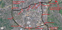
and includes this as Figure 8: Supertram Second City Crossing search area

second city crossing.png

Likewise the SYPN "Vision Doc" includes roughly the same alignment as a "Route under investigation" in the long-term map, although nothing specifically mentioned in the text.

Somewhat speculating at this stage, but it's fairly safe to guess this would involve extending the current line from West Street up Glossop Road to the RHH (which has been talked about for decades at this point), and then a line down either via the Inner Ring Road or Fitzwilliam Street to Moorfoot and then continuing to meet the current line somewhere south of the station.

There's a bit of a hint in the outline proposals for the Moorfoot regeneration area, which shows a tram line passing through the centre along Cumberland Street and continuing east to the south of the IRR.

OVERVIEW_10-010-A1-Proposed-Masterplan-Ground-scaled-e1778842785126.jpg

Notably the realistic plans quite deliberately doesn't show anything to the northwest, although the sketch drawing does show it connecting to Fitzwilliam Street.

DETAIL_250605_Intensified-Footprint-Sketch-scaled.jpg

Take it all with a grain of salt, especially the Moorfoot plans, but it's fairly clear that any expansion of the tram network is going to focus on these areas rather than entire new branches in the suburbs.

 
Last edited:

The Pelican

Member
Joined
3 Oct 2025
Messages
391
Location
London
It would be interesting to see how a Glossop Road tram line and a Moorfoot tram line would be operated- I guess the Glossop road line would be the destination of trams which entered the city centre section from the East, and then a Moorefoot line could either be an alternative set of tracks from around the University stop to somewhere south of the station, like Manchester's Second City Crossing, or operate as a circle line from the existing city center track.

I hope a Rotherham town centre spur is also considered, to give tram passengers better access to central Rotherham.
 

MarkyT

Established Member
Joined
20 May 2012
Messages
7,549
Location
Torbay
I hope a Rotherham town centre spur is also considered, to give tram passengers better access to central Rotherham.
Central station is under 300m from the Minster as the crow flies. Most of the town centre is within a few minutes' walk. I can't see the point unless a new line was projected across the town centre to somewhere in the east.
 

Top