david_g
Member
Noticed driving past (hence no photos) yesterday that the bridge beams have been installed on the piers for the Itchen viaduct just south of the Long Itchington tunnels.

Despite the YouTube video description, I don’t think that’s an HS2 bridge, it’s the Southeast Aylesbury relief road.Drone video of the large crane and bridge beams, about to be installed across a railway at Aylesbury
Drone video of the large crane and bridge beams, about to be installed across a railway at Aylesbury
Indeed nothing to do with HS2 directly. The bit of SEALR that interfaces with HS2 is further west and is already open. This is in the gap further east between section linked to the new HS2 roads and the A41Despite the YouTube video description, I don’t think that’s an HS2 bridge, it’s the Southeast Aylesbury relief road.
True, but have they temporarily pinched the crane from OOC?Indeed nothing to do with HS2 directly. The bit of SEALR that interfaces with HS2 is further west and is already open. This is in the gap further east between section linked to the new HS2 roads and the A41
The 2nd video is great but you have to wonder for the justification of the scale of the temporary land take to build this section. Also why such a substantial overbridge on the line of the redundant GCR?A new video, which is in form of lots of aerial still shots with a detailed description has been posted. Says it was filmed in December (presumably over Christmas shutdown as all the dump trucks are parked up)
Covers area from Colne Valley viaduct to East West rail crossing near Calvert
== Doublepost prevention - post automatically merged: ==
Another new drone video, showing HS2 construction in the Radstone area (just north of Brackley).
An area that doesn't get that many updates, so gives an idea of progress on this stretch.
It’s one of many ‘green bridges’ all along the route that are supposed to provide for a ‘wildlife friendly corridor’ for animals to cross the railway. It’s not just a footpath.The 2nd video is great but you have to wonder for the justification of the scale of the temporary land take to build this section. Also why such a substantial overbridge on the line of the redundant GCR?
The 2nd video is great but you have to wonder for the justification of the scale of the temporary land take to build this section. Also why such a substantial overbridge on the line of the redundant GCR?
We are extending our working hours.
This is subject to the local authority consents, approvals and ongoing review.
Activities will include, installing the tunnel structure and using concrete produced at our on-site batching plant, as well as backfilling the area around the tunnel with layers of earth. The activities will take place in the tunnel cutting in the area between Aston le Walls and Chipping Warden. For safety reasons, lighting will be in required and there may be some operational noise from vehicles and other machinery. The exact location will change as the work progresses northwards.
 www.hs2.org.uk
We are extending our working hours.
This is subject to the local authority consents, approvals and ongoing review.
Activities will include, installing the tunnel structure and using concrete produced at our on-site batching plant, as well as backfilling the area around the tunnel with layers of earth. The activities will take place in the tunnel cutting in the area between Thorpe Mandeville and Greatworth. For safety reasons, lighting will be in required and there may be some operational noise from vehicles and other machinery.
www.hs2.org.uk
You would have thought sections in the open with largely just earthworks would be the most advanced of the sections yet we find the Colne Valley viaduct as being the most completed part of the project.A new drone video of the Southam to Leamington area HS2 construction.
Looks like some of the overbridges now in use and lot of landscaping has already been done, and some of the haul roads have now been landscaped too. But areas near bridges are still getting lot of earth moving to complete the route.
The width of the disturbed ground relative to final finished cutting width seems excessive as almost appears in places took an extra field on a temporary basis.
== Doublepost prevention - post automatically merged: ==
HS2 have announced that there will be extended working hours at Greatworth and Chipping warden cut and cover tunnel sites from April to end October. 7am Monday to midnight Friday and 7am -6pm weekends
Looks like having to do long hours to complete the work. Possibly behind schedule after wet winter and want to get as much as possible during drier summer months
Notice of extended working hours at EKFB Chipping Warden
We are extending our working hours. This is subject to the local authority consents, approvals and ongoing review. Activities will include, installing the tunnel structure and using concrete produced at our on-site batching plant, as well as backfilling the area around the tunnel with layers of...
Notice of extended working hours at EKFB Greatworth
We are extending our working hours. This is subject to the local authority consents, approvals and ongoing review. Activities will include, installing the tunnel structure and using concrete produced at our on-site batching plant, as well as backfilling the area around the tunnel with layers of...
== Doublepost prevention - post automatically merged: ==
New drone video of HS2 near Fairford Leys (Aylesbury)
Seems to be lots of ground disturbance, heaps of materials etc, but no sign of trackbed for part of this section.

A new video has been posted showing Hunningham Road bridge which video says opened to road traffic today.
Video suggests this is 20th (of 126) bridges to open
I was thinking about that, and I suspect they were asked by the planners to keep it to a single lane, as that’s the quality of the existing road either side. But then the humped nature of the bridge means you can’t see oncoming traffic. So they’ve added various passing places. But a straightforward 2 lanes over the hump would be all round safer, with appropriate ‘road narrows’ on the downhill stretch either side.Could have at least built it one lane each direction!
www.hs2.org.uk
This will be over the top of the green tunnel close to the southern portal and would need all the landscaping completed including all haul roads removed. The extension possibly points to some where near the southern end of tunnel mouth being used as an access point for staff etc. (e.g. staff carpark) during track system fit out (e.g. about 21-22km north of Calvert) with road access from Welsh Road?HS2 have issued some updates, one of which is a footpath closed in 2023 to construct Greatworth tunnel.
Now says footpath will need to stay closed until November 2028.
I have to admit to being surprised another 2.5 years will be needed to build this tunnel, makes me wonder when they will be able to start laying track etc.
Update: Notice of closure, Helmdon Road, Greatworth and footpath AN13
Helmdon Road and footpath AN13, near Greatworth were closed in Autumn 2023 to allow us to complete the construction of the Greatworth green tunnel. Location Helmdon Road, Greatworth and footpath AN13. Duration From Autumn 2023 until completion of the Greatworth green tunnel, which is expected to...

 www.facebook.com

As per one of the comments on facebook, is it not just that it’s a bridle way that HS2 are obliged to provide a crossing for? I believe HS2 have a common set of parts, so it looks like rail spec because it’s not worth designing something lesser?19K views · 111 reactions | Drone footage showing the strange bridge going in over HS2 on the former GCR route. #HS2 | NWP Exploring
Drone footage showing the strange bridge going in over HS2 on the former GCR route. #HS2
Just seen this video on Facebook which shows a drone flyover along the GCML alignment and shows a new bridge being put in over where the alignment crosses HS2 near Brackley
Why is this being done? I'm pretty sure the alignment isn't getting used again any time soon and putting in a full rail spec bridge like what seems to be getting built in the video. Unless there's something I don't know and the GCML does have a future.
Attached screenshot showing the bridge for those who do not have Facebook.
View attachment 204382
 www.railforums.co.uk
HS2 has far simpler designs for footbridges, of which there are many across the route.As per one of the comments on facebook, is it not just that it’s a bridle way that HS2 are obliged to provide a crossing for? I believe HS2 have a common set of parts, so it looks like rail spec because it’s not worth designing something lesser?
Yes, it was added in on of the many redesigns since the initial public plans. It serves as a bridge for footpath AX15, which will be diverted to cross it, as well as a green overbridge. In initial plans the footpath wasn’t diverted and crossed on a far more minimal bridge, while the green bridge didn’t exist.It’s also one of a large number of wider than normal “green bridges” designed to provide for a safe wildlife corridor across the railway.
It was last mentioned (with a video), in the thread here:
HS2 Construction Updates -Long Itchington to Great Missenden / Chilterns North Portal
Noticed driving past (hence no photos) yesterday that the bridge beams have been installed on the piers for the Itchen viaduct just south of the Long Itchington tunnels.
A43 Southbound
8pm Friday 10 July to 7am Sunday 12 July 2026
A43 Northbound
8pm Friday 17 July to 7am Sunday 19 July 2026
As a contingency, should there be delays, full weekend lane closures will take place on:
Southbound Friday 24 July to 7am Sunday 26 July 2026
Northbound Friday 31 July to 7am Sunday 2 August 2026
What to expect
A section of the A43 carriageway in one direction will be closed in July to facilitate the tie-in of the new A43 realignment over the bridge.
www.hs2.org.uk
While lots have been scheduled to complete this summer progress has often looked slow in many cases (e.g. funding rate constrained) so many may open later than expected.On a more general note, seems to be lots of bridges along the route opening this summer, which will allow the missing sections of trackbed to be dug out, or filled where roads currently run.

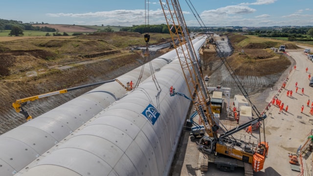
The construction of one of the longest ‘cut and cover’ tunnels on the HS2 project took a major step forward this week with the last of 5,020 reinforced concrete segments lifted into position at the site near Chipping Warden in Northamptonshire.
Set to stretch for one-and-a-half miles (2.5km), the ‘green tunnel’ is being built inside a cutting, with the earth put back on top afterwards, helping to blend the high-speed railway into the landscape and cut noise and disturbance for people living nearby.
There are five green tunnels on the HS2 project between London and Birmingham with two others, at Burton Green, in Warwickshire, and Copthall, on the outskirts of London, rapidly approaching completion.
Assembled from precast concrete segments, Chipping Warden green tunnel is in an ‘M’ shape, with separate halves for northbound and southbound trains. With the pre-cast wall installation now finished, the team are focused on completing the waterproofing and internal floor slab and all other internal works, including the emergency walkways that will run alongside the track.
To speed up construction, the tunnel was built in two parts, which joined together this week with the final segments lifted into position near the A361. Whenever possible, excavation, preparatory work, construction and backfilling were also happening simultaneously at different points along the structure to further improve efficiency.

A lot of the earlier anti-HS2 activism was decrying the environmental effects of building a new railway through the "green and pleasant land", which was basically NIMBYism disguised as tree-hugging.'Green tunnels' implies that there was absolutely zero engineering need for them.
While anti HS2 activists slander HS2 as a 'vanity project'. I would counter that the methods of building HS2, were the only 'vanity' aspect of the project.
The north western end does have a purpose. The downhill gradient is significant, and therefore the cutting width (at the required slope angle) would have to be much wider than typical. So it avoids a big chunk out of the local landscape and tree line. But that’s doesn’t apply to the majority of the tunnel.Building a 1.5 mile cut and cover tunnel through a disused airfield/industrial estate is an astonishing way to use public money. How did this happen?
