Our new ticketing site is now live! Using either this or the original site (both powered by TrainSplit) helps support the running of the forum with every ticket purchase! Find out more and ask any questions/give us feedback in this thread!
Fair enough, I take that point. Though that would still be possible via Minster, albeit maybe less conveniently.
If the coastal route did ever have to be abandoned at some time in the future, there would need to be a considerable revision of the east Kent routes and timetables anyway!
Fair enough, I take that point. Though that would still be possible via Minster, albeit maybe less conveniently.
If the coastal route did ever have to be abandoned at some time in the future, there would need to be a considerable revision of the east Kent routes and timetables anyway!
So does this mean building new lines ?, if so could these be built straighter , while still still serving the same areas that have stations if so , they could build lines with higher speed limits , and perhaps use a train design similar to the class 395's, the relative to the IET's..
This in a roundabout way might see Network rail and GWR reopening beyond oakhampton westwards to where that line used to go, as a backup route or the new mainline to the far southwest .
What if that 'something' is to avoid shovelling money into what is a fast-opening pit? The presence of Cliffs should indicate quite clearly that the railway will be fighting a losing battle for ever more.
At this point it's carrying a fraction of the traffic though. Dover has quicker services to anywhere other than Ashford/Tonbridge via other routes (although see later in this post for my thoughts on this connectivity)
This is hilariously over the top reactionism. The political situation is totally different now. It also works actively against the rail network as a whole because they are not allowed to adjust in the face of changing patterns or challenges.
I can see there being reasonable demand for traffic from Tonbridge/Ashford (and connections) to Folkestone and Dover - they're big employer sites related to cross-channel traffic. loss of through connectivity to Dover would seriously harm the local economy in this area. However whether that connectivity has to be provided by a route precisely on the existing line I'm less convinced.
Because a railway now costs so much to build, I suspect any appraisal of retention vs diversion is going to say it'll be cheaper to maintain the existing route for 100 years. Even if it means dumping 10,000 tons of rocks alongside it every year.
It does feel like we are very slow to unleash the power of our Universities on all things climate resilience.
This really needs to change. We need to put our not insignificant national brain power to work with infrastructure owners to hunt out the best value, clever solutions. There will absolutely be some wins hiding in there.
Because a railway now costs so much to build, I suspect any appraisal of retention vs diversion is going to say it'll be cheaper to maintain the existing route for 100 years. Even if it means dumping 10,000 tons of rocks alongside it every year.
It's a lot more complicated than that, the line was built across what is basically an enormous landslip, and has needed significant work to keep it open in the past. Add climate change to the mix and it's going to be expensive.
Because a railway now costs so much to build, I suspect any appraisal of retention vs diversion is going to say it'll be cheaper to maintain the existing route for 100 years. Even if it means dumping 10,000 tons of rocks alongside it every year.
Wouldn't a new railway alignment between Dover - Folkestone, slightly inland away from the cliff face, be relatively cheap? It's mostly farmland with very little building development.
Wouldn't a new railway alignment between Dover - Folkestone, slightly inland away from the cliff face, be relatively cheap? It's mostly farmland with very little building development.
The railway is at the bottom of the cliff, so 'slightly inland' means an elevation change of about 150-200 feet up. You might be able to get an alignment from Dollands Moor via Hawkinge to Kearsney but it'll involve a lot of earth moving and at least 1 major tunnel.
Google Maps's terrain view is quite helpful for a rough guide to local topographies.
The railway is at the bottom of the cliff, so 'slightly inland' means an elevation change of about 150-200 feet up. You might be able to get an alignment from Dollands Moor via Hawkinge to Kearsney but it'll involve a lot of earth moving and at least 1 major tunnel.
Google Maps's terrain view is quite helpful for a rough guide to local topographies.
Wouldn't a new railway alignment between Dover - Folkestone, slightly inland away from the cliff face, be relatively cheap? It's mostly farmland with very little building development.
It will be inevitable at some time in the future. It may be dozens of years, or hundreds - but like other parts of the coastline, the sea will eventually "win", and the cliffs will collapse into the sea.
Seems like the kind of thing that might need a new TWA order (since it would basically be a new railway) so should probably be specifically funded as such, rather that coming out of NR's agreed budget.
It will be inevitable at some time in the future. It may be dozens of years, or hundreds - but like other parts of the coastline, the sea will eventually "win", and the cliffs will collapse into the sea.
Wouldn't a new railway alignment between Dover - Folkestone, slightly inland away from the cliff face, be relatively cheap? It's mostly farmland with very little building development.
Let’s run the railway along the hard shoulder of the A20 !
Question: what gradient can a modern railway manage, compared to a modern trunk road?
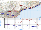
Here’s a map with the approximate gradient profiles of the current railway and the M20 / A20, from just west of Cheriton where they are close together, to Dover. Don’t take the profile too literally, just get the general impression. The road has some significantly steep sections, by railway standards.
It does feel like we are very slow to unleash the power of our Universities on all things climate resilience.
This really needs to change. We need to put our not insignificant national brain power to work with infrastructure owners to hunt out the best value, clever solutions. There will absolutely be some wins hiding in there.
The problem is a lot of the answers are not the ones that the policymakers will be looking for.
As an academic, a substantial amount of the time a funder expects a certain predetermined result from a study, which is why they funded it in the first place.
If you ask for the "best value, clever solutions", you might not get the solutions you were expecting.
This is potentially very bad news for a politician.
Dover & Deal constituency is expected to swing Labour in this election, plus Folkestone & Hythe, while not as comfortable, could also swing Labour. Either or both of these becoming Labour will make maintaining this line a hot issue for them, as it can be argued their seats depend on it.
The railway is at the bottom of the cliff, so 'slightly inland' means an elevation change of about 150-200 feet up. You might be able to get an alignment from Dollands Moor via Hawkinge to Kearsney but it'll involve a lot of earth moving and at least 1 major tunnel.
Google Maps's terrain view is quite helpful for a rough guide to local topographies.
I was also thinking of alongside the existing route of the Channel Tunnel railway. That cuts out the highest gradient part in the middle of the route you suggest.
I was also thinking of alongside the existing route of the Channel Tunnel railway. That cuts out the highest gradient part in the middle of the route you suggest.
Coming from the west, the Channel Tunnel line enters a tunnel at a point due north of Folkestone West station and remains in tunnel until France. It crosses the coastline at a point under Shakespeare Cliff. It passes under very steep ground at several places.
The railway wall at Dawlish has, well, Dawlish behind it - look at it the other way & you're funding a sea wall for Dawlish that has a railway on it. Plus ofc the only route to Plymouth & Cornwall etc.
If you can frame this one in those terms somehow, then maybe there'll be more interest. Is whatever's deteriorating that's risking the line affecting residents somewhere?
Current recommended design standard for a railway is max gradient of 1 in 100 for a line carrying freight, 1 in 80 for a line not expected to carry freight.
Not sure how that compares to a road but my instinctive reaction is that the A20 exceeds it by quite a way. There's also curvature to consider.
== Doublepost prevention - post automatically merged: ==
Dover & Deal constituency is expected to swing Labour in this election, plus Folkestone & Hythe, while not as comfortable, could also swing Labour. Either or both of these becoming Labour will make maintaining this line a hot issue for them, as it can be argued their seats depend on it.
Labour are likely to have a secure enough victory that 2 seats won't matter to them, and there are other issues voters will prioritise above a railway.
What if that 'something' is to avoid shovelling money into what is a fast-opening pit? The presence of Cliffs should indicate quite clearly that the railway will be fighting a losing battle for ever more.
At this point it's carrying a fraction of the traffic though. Dover has quicker services to anywhere other than Ashford/Tonbridge via other routes (although see later in this post for my thoughts on this connectivity)
This is hilariously over the top reactionism. The political situation is totally different now. It also works actively against the rail network as a whole because they are not allowed to adjust in the face of changing patterns or challenges.
I can see there being reasonable demand for traffic from Tonbridge/Ashford (and connections) to Folkestone and Dover - they're big employer sites related to cross-channel traffic. loss of through connectivity to Dover would seriously harm the local economy in this area. However whether that connectivity has to be provided by a route precisely on the existing line I'm less convinced.
Because a railway now costs so much to build, I suspect any appraisal of retention vs diversion is going to say it'll be cheaper to maintain the existing route for 100 years. Even if it means dumping 10,000 tons of rocks alongside it every year.
If you were to look back at history from the 1940's you might well think that the line was a money pit. The fact remains that a technical solution was found that made the route good for another seventy years. Attention needs to be given to a longer term solution again.
You are naive in the extreme if you don't think that there will be lots of people high up, sniffing around for other awkward main lines they can do away with, if they get away with this one.
I don't know whether the overtures from NR are an attempt to obtain more resource to tackle the climate change threat - in which case fair play, or whether its a more problematic attempt to alter the country's commitment to maintaining the network. If the latter, it needs to be nipped in the bud.
== Doublepost prevention - post automatically merged: ==
It does feel like we are very slow to unleash the power of our Universities on all things climate resilience.
This really needs to change. We need to put our not insignificant national brain power to work with infrastructure owners to hunt out the best value, clever solutions. There will absolutely be some wins hiding in there.
Indeed. There must be tens, if not hundreds of geology departments around the country's University sector. Give them something to get their teeth into.
== Doublepost prevention - post automatically merged: ==
Dover & Deal constituency is expected to swing Labour in this election, plus Folkestone & Hythe, while not as comfortable, could also swing Labour. Either or both of these becoming Labour will make maintaining this line a hot issue for them, as it can be argued their seats depend on it.
Not to mention there's a major aquifer there (being chalk), so tunnelling work will involve an extensive dewatering job.
Not that many Geology departments left these days and Geoscience as a whole is struggling to attract students.
In any case, you would probably need geotechnical engineers and they seem to be even rarer in universities!
Getting back on topic, I suspect Network Rail have a lot more problems like this looming elsewhere (see all those other threads on here re landslides) and by flagging this bit now, they might just get it onto the radar of whoever forms the next Government or more likely, makes the locals sit up and start lobbying to ensure a fix is found.
If you were to look back at history from the 1940's you might well think that the line was a money pit. The fact remains that a technical solution was found that made the route good for another seventy years. Attention needs to be given to a longer term solution again.
Closure is a viable long term solution, with a chord at Canterbury to preserve local access. If the line had terminated at Folkestone nobody would be seriously proposing a line on this alignment.
You are naive in the extreme if you don't think that there will be lots of people high up, sniffing around for other awkward main lines they can do away with, if they get away with this one.
I'm sure some are looking at it, because considering closure is part of a sensible process of evaluation. However you are at conspiracy theory level if you refuse to recognise the political reality that closures of direct links between towns the size of Dover and Folkestone would not be politically sanctioned. Nor is there going to be anything like another Beeching or Serpell report.
Out of interest, if closure of this line unlocked sufficient room in the budget to reopen a different line, would you sanction it?
I don't know whether the overtures from NR are an attempt to obtain more resource to tackle the climate change threat - in which case fair play, or whether its a more problematic attempt to alter the country's commitment to maintaining the network. If the latter, it needs to be nipped in the bud.
It's almost certainly an attempt to obtain more funding. But it will also be intended to prompt a discussion at a political level about what the appropriate responses to climate change are.
Not that many Geology departments left these days and Geoscience as a whole is struggling to attract students.
In any case, you would probably need geotechnical engineers and they seem to be even rarer in universities!
Getting back on topic, I suspect Network Rail have a lot more problems like this looming elsewhere (see all those other threads on here re landslides) and by flagging this bit now, they might just get it onto the radar of whoever forms the next Government or more likely, makes the locals sit up and start lobbying to ensure a fix is found.
Closure is a viable long term solution, with a chord at Canterbury to preserve local access. If the line had terminated at Folkestone nobody would be seriously proposing a line on this alignment.
This line of argument is frequently used against reopening proposals. I wondered how long it would be before it was used against the existing network. Now I have an answer.
I'm sure some are looking at it, because considering closure is part of a sensible process of evaluation. However you are at conspiracy theory level if you refuse to recognise the political reality that closures of direct links between towns the size of Dover and Folkestone would not be politically sanctioned. Nor is there going to be anything like another Beeching or Serpell report.
That's the problem, isn't it. Closure becomes a pernicious creeping threat in an environment where it is sanctioned. It wasn't so long ago that the cost of repairing Ribblehead viaduct was being inflated to justify closure.
If we're paranoid, it's because we have seventy years of railway history to inform us.
It's almost certainly an attempt to obtain more funding. But it will also be intended to prompt a discussion at a political level about what the appropriate responses to climate change are.
The A625 trans Pennine route disappeared from the map for exactly the same reason, long-term instability that was too expensive to overcome. Traffic was rerouted via an alternative route, just as rail traffic to Dover might have to be.
This isnt a unique problem. Its a complex landslide and more importantly its bloody massive on all scales. I was talking to someone at Rail Live about the monitoring in-situ there about just how sketchy the landslip is.
Its a giant rotational failure with the toe beneath sea level and the back scarp way way beyond the railway at the top. This is also full of many smaller landslides. Increased groundwater levels from wetter weather is causing an issue also.
Remedial measures for deep-seated earthworks are varied and toe weighting is a method that is used and has been used here, however it only offers short term stability. To remediate this you would need significant deep piling and earthworks over a colossal area making things like Eden Brows pale in comparison. There isnt an infinite money pot and the money you would spend to remediate this fully, could be spent remediating/renewing a lot of other sites.
Decisions will have to be made over things like this and the weighing up of costs and benefits of which lines to prioritise, crying that this is the thin end of the wedge and is essentially Beeching Mk2 and closure by stealth helps no one.
We are aware of an issue with emails from the Forum to Microsoft-based email accounts (hotmail/outlook/live.com email addresses). This is being looked into currently, thanks for your patience meanwhile.